
Cyprus holds secrets within its dry earth and sun-bleached stones. Choirokoitia stands as a premier testament to human endurance and early architectural skill. This Neolithic settlement predates most modern civilizations. It sits perched on a hillside near the Maroni River.
Visitors feel a shift in time as they approach the rugged landscape. The air carries scents of wild thyme and carob trees. History breathes through the ancient limestone walls. This nature trail connects the archaeological site to the natural world. It provides a bridge between past lives and current footsteps. Every turn reveals a new perspective on how ancestors lived. The journey starts here.
- Trail Overview
- The Historical Significance of Choirokoitia
- Flora and Fauna Along the Trail
- Architectural Marvels of the Neolithic Era
- Geological Features of the Maroni Valley
- Seasonal Changes and Visitor Experience
- The Social Structure of Ancient Residents
- Conservation Efforts and Site Protection
- Panoramic Views and Photography
- Local Culture and Nearby Attractions
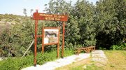
Trail Overview
- Location: Choirokoitia Village, Larnaca District, Cyprus
- Distance: 2.4 kilometers (1.5 miles)
- Route Type: Out & Back
- Difficulty: Moderate
- Elevation Gain: 120 meters
- Duration: 45 to 60 minutes
- Best Time to Visit: February to April
- Terrain: Dirt paths and stone steps
The Historical Significance of Choirokoitia
The United Nations Educational, Scientific and Cultural Organization recognizes this location as a World Heritage site. It represents one of the most important prehistoric sites in the eastern Mediterranean.
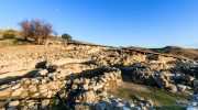
The settlement dates back to the 7th millennium BC. Residents built circular houses out of mudbrick and stone. These structures demonstrate an advanced grasp of communal living and defense. The trail circles these ruins and provides an elevated view of the entire complex.
This perspective helps visitors understand the strategic choice of this hillside. It offered clear views of the valley to monitor for threats. The site remains a puzzle for archaeologists who study the transition from nomadic life to permanent village structures.
Flora and Fauna Along the Trail
Nature thrives in this semi-arid climate despite the harsh summer sun. The trail features a variety of endemic plants that adapt to low water levels. Carob trees provide shade at several points along the ascent. Olive trees dot the landscape with silver leaves that shimmer in the breeze.

Wild shrubs like lentisk and rockrose fill the spaces between rocks. These plants bloom in early spring and create a colorful carpet across the hills. Local birds often nest in the dense brush. Short-toed eagles sometimes soar above the valley in search of prey. Reptiles like the Cyprus whip snake sun themselves on the warm stones during the day. This ecosystem supports a delicate balance of life that thrives alongside the silent ruins.
Architectural Marvels of the Neolithic Era
The builders of Choirokoitia utilized local materials to create a sophisticated urban environment. They constructed thick walls to keep interiors cool during the intense heat. These circular homes often featured a central hearth for heat and food preparation. Some houses contained lofts supported by stone pillars.
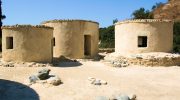
The trail allows a close look at the reconstruction projects near the entrance. These replicas use the same techniques as the original inhabitants. They provide a tangible sense of scale and space. The precision of the stone masonry reflects a high level of social organization. This community shared resources and labor to maintain their hilltop fortress. It serves as a blueprint for early Mediterranean urbanism.
Geological Features of the Maroni Valley
The Maroni River shaped this landscape over millions of years. It carved a deep valley that provided water and fertile soil for the first farmers. The trail follows the contours of the limestone cliffs. These white rocks contrast sharply against the deep blue sky. Fossils sometimes appear in the sedimentary layers of the stone.
This geology influenced the lifestyle of the ancient people. They used the river cobbles for tools and building foundations. The soil in the valley below still supports agriculture today. Farmers grow citrus and olives in the silt deposits left by the river. This continuity of land use connects the ancient past to modern Cyprus.
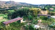
Seasonal Changes and Visitor Experience
Weather dictates the mood of the Choirokoitia Nature Trail. Winter rains turn the brown hills into a vibrant green paradise. This period offers the most comfortable temperatures for a hike. Summer brings intense heat that makes the ascent a challenge. Most people prefer the early morning hours to avoid the peak sun.

Autumn sees a return of cooler breezes and clear vistas. Each season highlights a different aspect of the Cypriot wilderness. The trail remains well-marked with wooden signs and informative placards. These markers explain the botanical and historical features of the route. Visitors should wear sturdy shoes to navigate the uneven stone steps. Water is a necessity because the trail offers little shelter from the elements.
The Social Structure of Ancient Residents
Evidence suggests that hundreds of people once lived within these walls. They practiced agriculture and raised livestock like sheep and goats. Excavations revealed that they buried their dead under the floors of their homes. This practice indicates a deep spiritual connection to their ancestors.
The community functioned as a cohesive unit to survive the challenges of the Neolithic age. They produced intricate stone bowls and jewelry from local minerals. These artifacts show an appreciation for aesthetics beyond simple utility. The trail overlooks the burial sites and living quarters. It prompts reflection on the daily routines of a lost civilization. Their success paved the way for future cultures on the island.
Conservation Efforts and Site Protection
The Department of Antiquities in Cyprus manages the upkeep of this sensitive area. They work to prevent erosion from wind and rain. Protective roofs cover some of the most fragile ruins. These efforts ensure that future generations can witness this history. The nature trail itself receives regular maintenance to keep paths clear.
Rangers monitor the impact of foot traffic on the local plant life. Sustainable tourism remains a priority for the local government. Visitors must stay on the marked paths to avoid damage to unexcavated areas. This balance between public access and preservation is vital. The site serves as an outdoor museum and a natural sanctuary.
Panoramic Views and Photography
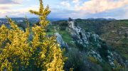
Photographers find endless inspiration along the ridges of the trail. The elevated path offers a 360-degree view of the surrounding countryside. To the south, the Mediterranean Sea sparkles on the horizon.
To the north, the foothills of the Troodos Mountains rise in the distance. The contrast between the ancient grey stones and the green valley creates a striking image. Sunset provides a golden light that softens the harsh edges of the landscape.
Shadows stretch across the circular foundations and reveal the layout of the old streets. This visual record captures the intersection of human history and natural beauty. It remains one of the most photogenic spots on the island.
Local Culture and Nearby Attractions
The village of Choirokoitia sits just a short distance from the trailhead. It maintains a traditional character with stone houses and narrow alleys. Local taverns serve authentic dishes like halloumi cheese and fresh olives. Many visitors combine a hike with a meal in the village. This support helps the local economy and preserves traditional crafts.
Nearby workshops produce baskets and lace in the old style. These traditions likely have roots that stretch back centuries. The proximity of the trail to the main highway makes it an easy stop for travelers. It offers a quick escape into nature without a long detour.

Choirokoitia Nature Trail offers a unique look at the dawn of civilization. The path winds through ancient history and resilient Mediterranean flora. Every step reveals the skill of Neolithic builders and the beauty of the Cypriot landscape. The trail provides a quiet space for reflection on the human journey. It remains a vital link to the heritage of the island. Travelers gain a deep respect for the ancestors who tamed this hillside. This destination combines exercise with education in a profound way. The stones tell a story that still resonates today. Visit this site to witness the past.


