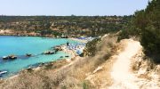
The Konnoi to Cyclops Cave trail offers a unique path through the Cape Greco National Forest Park. This route winds along the eastern coastline of Cyprus where the Mediterranean Sea meets rugged limestone cliffs. Hikers encounter a landscape shaped by volcanic activity and salt spray over millions of years.
The path remains popular for those who seek natural beauty far from the crowded resort beaches. This trek provides a direct link between the famous Konnos Bay and the legendary limestone cavern known as Cyclops Cave. Each step reveals a different aspect of the island’s ancient geological history. It serves as a vital corridor for local flora and fauna.
Trail Overview
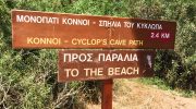
- Location: Cape Greco National Forest Park, Ayia Napa, Cyprus
- Distance: 1.5 miles (2.4 km)
- Route Type: Point-to-Point (or Out & Back)
- Difficulty: Easy
- Elevation Gain: 130 feet (40 meters)
- Duration: 45 – 60 minutes
- Best Time to Visit: September–May or at Sunrise
- Terrain: Rocky, Coastal, uneven limestone
The Geological Foundation of Cape Greco
The region of Cape Greco consists mainly of sedimentary rock and fossilized coral reefs. This specific trail sits on a plateau that rose from the sea during the Pleistocene epoch. As you walk the path you notice the sharp edges of the calcarenite stone. This material forms the base of the entire peninsula.
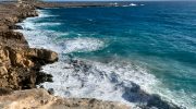
Wind and waves erode the softer parts of the cliff side to create sea caves. The Cyclops Cave is the most prominent result of this natural process. It serves as a testament to the power of the ocean over time. You see clear layers of history within the rock faces that line the route.
Small shrubs and hardy plants dominate the landscape near the shore. These species survive in soil with high salt content and low moisture levels. One common plant is the Phoenician juniper which grows slow and strong against the sea breeze.
You also find wild herbs like thyme and rosemary that release scents into the warm air. Migratory birds often use this area as a rest stop during their long flights across the sea. Lizards sun themselves on the warm rocks during the midday heat. This ecosystem supports a variety of insects that pollinate the rare wild flowers in spring. Nature remains undisturbed within the boundaries of the national park.
Step-by-Step Route Details
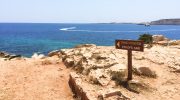
The journey starts at the southern end of Konnos Beach. A clear signpost marks the entrance to the coastal track. You follow a narrow path that hugs the edge of the cliff. The ground feels solid but the surface stays uneven due to the nature of the rock.
Safety rails exist in certain sections where the drop to the water is steep. You pass several small coves where the water looks turquoise and clear. The path remains mostly flat with only a few gentle slopes. You reach the cave after about one kilometer of steady pace. This site provides shade and a place to rest before you return.
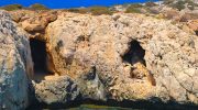
The Legend and Structure of Cyclops Cave
Local stories link this cavern to the ancient myths of Homer. While no evidence proves a giant lived here the size of the cave is impressive. It features a wide entrance that overlooks the sea. Inside the ceiling reaches high into the rock. The walls show signs of human use from centuries ago.

Small chambers branch off from the main hall. It stays cool inside even when the sun beats down on the exterior. The view from the mouth of the cave offers a wide panorama of the Levantine Sea. Visitors often sit here to watch the boats pass in the distance.
Safety and Preparation for Hikers
Sun protection is a priority because the trail has very little shade. A sturdy pair of shoes helps you navigate the jagged stones. You must carry enough water to stay hydrated in the Mediterranean heat. Mobile phone signals stay strong throughout the park area. It is wise to tell someone your plans before you set out. The trail stays open all year but summer afternoons get very hot. Winter rains make some sections slippery so you should check the weather. Respect the environment and stay on the marked paths. This ensures the park stays clean for future guests.
The contrast between the yellow rock and the blue sea makes for great photos. You find the best light during the golden hour just before sunset. The perspective from the cliff top allows you to see the depth of the water. Rocks beneath the surface create dark patches in the bright blue sea. You can capture the texture of the ancient fossils embedded in the ground. The cave entrance frames the horizon in a natural arch. Many people take pictures of the rare plants that bloom in the cracks of the stone. Each turn of the path offers a new angle of the coastline.
Connectivity with Other Park Trails
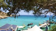
This specific segment connects to the larger Aphrodite Trail. You can extend your hike to reach the Blue Lagoon or the Monument of Peace. The park features a network of paths that cover the entire headland. All trails have clear markers with distance information. This allows you to plan a longer trek if you feel energetic. Many paths intersect near the visitor center. You can learn more about the park history at the local museum. The area serves as a hub for outdoor activities in eastern Cyprus. It provides a quiet escape from the nearby city noise.
The Konnoi to Cyclops Cave trail is a vital experience for any nature lover in Cyprus. This path combines geological interest with a simple physical challenge. You witness the raw beauty of the Mediterranean coast without the need for complex gear. The cave stands as a silent monument to the power of the natural world. It offers a moment of peace and a connection to the deep past of the island. Travelers find the route easy to access and very rewarding. This trek ensures that you see the true character of the Cape Greco region. It remains a highlight of the local landscape.