

12 Best Theme & Amusement Parks in Cyprus
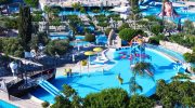
Cyprus is not the first destination that comes to mind for theme parks, but the island has developed a strong and varied collection of family attractions across the eastern Mediterranean. The range covers high-speed water parks in Ayia Napa, forest rope courses in the Troodos mountains, coastal funfairs in Protaras and Larnaca, and educational farm parks inland. Temperatures regularly exceed 35°C between June and September, which makes water parks a practical part of most summer itineraries rather than an optional extra. Beyond the beach, families have genuine options across every category, from full-day themed water parks with international award recognition to relaxed evening funfairs within walking distance of most coastal hotels. Best Amusement Parks In Cyprus These are traditional fairgrounds…
Read more