The Livadi Trail offers a serene path through the heart of the Troodos mountains. This route showcases a unique side of the island that few visitors see. It provides a peaceful escape into the cool mountain air far from the crowded beaches.

The path winds through a flat plateau that hosts rare plant life. Massive black pines tower above the track and offer deep shade. This specific environment supports a delicate ecosystem that remains green throughout the entire year.
Accessibility makes this location a favorite for those who want a gentle walk. The trail design accommodates people of all ages and fitness levels. Every section of the loop reveals a new perspective of the surrounding peaks and valleys.
Trail Overview
- Location: Troodos National Forest Park
- Distance: 1 mile (1.5 km)
- Route Type: Loop
- Difficulty: Easy
- Elevation Gain: 33 feet (10 meters)
- Duration: 45 minutes
- Best Time to Visit: May – October
- Terrain: Paved and Flat Forest Floor
Botanical Features and Rare Forest Species
The Livadi Trail sits at an altitude of seventeen hundred meters above the sea level. This height creates a specific climate that favors the growth of the Pinus nigra or black pine. These trees can reach ages of over five hundred years within the Troodos range. Their thick bark protects them from the cold winters and the frequent mountain storms. The forest canopy is quite dense here which helps to keep the ground moist and cool. This moisture supports a wide variety of ground plants and shrubs.
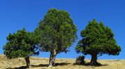
One of the most notable plants in this area is the golden oak. This tree is endemic to the island and features leaves with a yellow underside. It thrives in the shade of the larger pines and provides shelter for small forest animals. Hikers also notice the Greek juniper which adds a sharp and fresh scent to the air. The soil consists of volcanic rock that provides specific minerals to these mountain plants. This chemical balance is the reason why many of these species exist only in this part of the world.
Geological History of the Troodos Plateau
The ground beneath the Livadi Trail has a fascinating origin story. It is part of an ophiolite complex that formed on the ocean floor millions of years ago. Tectonic forces pushed this section of the crust high into the atmosphere. The rocks are rich in iron and magnesium which give the earth a dark and rusty color. Geologists from all over the planet visit this site to study the structure of the earth. The plateau provides a rare look at the deep layers of the mantle.
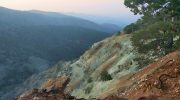
Small pebbles and stones cover much of the path surface. These fragments come from the erosion of the nearby peaks over countless centuries. The flat nature of the Livadi area is unusual for such a high altitude. It acts as a natural basin that collects rainwater and snowmelt. This water then seeps into the rock and feeds the springs in the lower valleys. The stability of the ground makes the walk very comfortable and safe for everyone.
Avian Biodiversity and Mountain Wildlife
The quiet environment of the trail makes it a perfect spot for bird watching. The endemic Cyprus wheatear is a frequent visitor to the open glades. It nests in the rocky crevices and feeds on the insects that live in the pine needles. Another common sight is the coal tit which moves quickly through the high branches. The sound of their calls is often the only noise that breaks the silence of the forest. This habitat is vital for the survival of these species during the breeding season.

Larger animals like the Cyprus mouflon sometimes enter the valley during the quiet hours. These wild sheep are very shy and prefer the dense cover of the trees. Their presence indicates that the ecosystem is healthy and well protected. Foxes also roam the area in search of small rodents that live in the undergrowth. The lack of steep drops makes it easier for these animals to move across the plateau. The trail offers a chance to see nature in a state of perfect balance.
Path Conditions and Accessibility Standards
The Livadi Trail is famous for its smooth and level surface. This makes it the most accessible path in the Troodos National Forest Park. It follows a wide loop that returns exactly to the starting point. There are several wooden benches placed at intervals along the route. These spots allow for rest and the observation of the distant mountain views. The signs are clear and provide information about the plants and animals in the area.

Maintenance crews check the path regularly to remove any fallen debris. This ensures that the track remains clear for those with limited mobility. The lack of steep inclines is a major draw for families with small children. It provides a safe space for people to explore the outdoors without any fear of injury. The proximity to the main road makes it a convenient stop during a mountain road trip. This accessibility is a key part of the local tourism strategy.
Seasonal Changes and Environmental Impact
Each season brings a new look to the Livadi Trail and the surrounding forest. Spring features the emergence of rare orchids and mountain wildflowers. These plants bloom for only a few weeks after the snow disappears. Summer offers a cool refuge when the heat in the cities becomes too intense. The temperature in the valley stays about ten degrees lower than the coast. This makes it a popular destination for those who want to exercise in comfort.
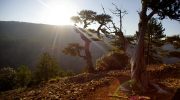
Autumn turns the golden oak leaves into a sea of bright yellow and brown. The air becomes crisp and the visibility across the island increases. Winter often covers the entire plateau in a deep layer of white snow. The black pines look striking against the pale ground during the cold months. The trail remains open but hikers should wear boots for the slushy sections. The cycle of the seasons ensures that no two visits to the valley are ever the same.
Conservation Efforts and Future Protection
The entire area falls under the protection of the Natura two thousand network. This international agreement aims to preserve the most important natural habitats in Europe. Rules are in place to prevent any fire or litter in the forest. The goal is to keep the air and the water as pure as possible. Educational groups often visit the trail to learn about the importance of biodiversity. They study the link between the trees and the survival of the mountain species.
Future plans include the addition of more information boards and seating areas. The authorities want to maintain the balance between tourism and nature. They monitor the number of visitors to ensure the path does not become too crowded. This careful management will protect the Livadi Trail for many decades to come. The forest remains a source of pride for the nation and a gift to all who visit. It is a place where the facts of nature are on full display.