
Moutti tis Choras Nature Trail offers a unique journey through the heart of the Pitsilia region in Cyprus. This path winds through the Adelfoi Forest and provides a deep look at the island’s botanical wealth. Hikers often seek this route for its quiet atmosphere and the panoramic views of the surrounding peaks.

The trail serves as a vital link between the natural landscape and the cultural history of nearby villages. It presents a clear view of the Madari ridge and the Spilia valley below. This introduction sets the stage for a walk that balances physical effort with the calm beauty of the Mediterranean high country.
Trail Overview
- Location: Adelfoi Forest, Nicosia District (Near Spilia/Kourdali)
- Distance: 2.5 miles (4 km)
- Route Type: Circular
- Difficulty: Moderate
- Elevation Gain: 150 meters
- Duration: 1.5 – 2 hours
- Best Time to Visit: March – May or September – November
- Terrain: Rocky, Forest Floor, Dirt Path
The Geological Identity of Adelfoi Forest
The Moutti tis Choras Nature Trail sits on a bedrock of diabase and gabbro. These igneous rocks date back millions of years to the formation of the Troodos ophiolite. Scientists study this area because it reveals how the oceanic crust rose from the sea. As you walk, the stones underfoot tell a story of ancient volcanic activity.
The soil remains thin but supports a hardy range of flora. This rugged foundation dictates the sharp rises and falls of the path. Each step brings you closer to the skeletal frame of the island. The craggy outcrops provide perfect vantage points for the valley below.
Botanical Diversity Along the Path
Vegetation on this trail thrives despite the harsh summer sun. The Golden Oak is a primary feature and grows only on this island. Its leaves show a distinct yellow underside that catches the light. Beside these oaks, the Calabrian pine dominates the upper canopy. These trees offer a scent that fills the air on warm afternoons.

Wild lavender and rock rose populate the lower brush. These plants survive with very little water throughout the year. They bloom in spring and paint the hills in shades of purple and white. This plant life creates a sanctuary for local insects and small reptiles.
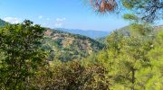
Summit Views & Wildlife
The high point of the trail provides a 360-degree view of the central mountain range. To the north, the Morphou Bay sparkles on a clear day. One can see the Pentadaktylos range in the far distance. To the south, the peaks of Troodos stand tall against the blue sky. This spot allows a person to grasp the scale of the Cypriot landscape. The wind often picks up at this altitude and cools the skin. It is a place where silence dominates the environment. The visual contrast between the green pines and the grey rocks is striking. It offers a moment of reflection for every traveler.
The Adelfoi Forest acts as a corridor for many bird species. The Cyprus wheatear and the Cyprus warbler nest in these shrubs. These birds exist nowhere else on the planet. Careful observers might spot a Bonelli’s eagle as it circles above the cliffs. Lizards scuttle across the rocks to soak up the heat. Occasionally, a Mouflon might appear in the distance. This wild sheep is a symbol of the nation’s natural heritage. The ecosystem remains delicate and requires respect from every visitor. Human noise stays low so that these creatures remain undisturbed.
The Heritage of Nearby Villages
The trail begins and ends near the village of Spilia. This settlement retains a traditional character with stone houses and narrow streets. History runs deep here as the residents once used these forest paths for trade. They carried crops and wood between mountain communities.
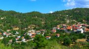
The church of Agios Antonios in the village dates back several centuries. It holds icons that reflect the religious devotion of the local people. A visit to the trail is incomplete without a stop in these quiet hamlets. The connection between the land and the people remains strong. It shows how life adapts to a mountain environment.
Conservation Efforts and Environmental Impact
The Department of Forests manages this area with care. They maintain the path to prevent erosion and protect the soil. Signage informs visitors about the rare plants they might see. It is vital to stay on the marked path to avoid damage to the flora. Fire is a major risk in the dry summer season.

Smoking and open flames are strictly forbidden in the forest. Litter must go back with the hiker to keep the trail clean. These rules ensure that future generations enjoy the same pristine beauty. Nature remains a resource that requires constant protection.
The Physical Benefits of the Ascent
A hike on this trail provides a moderate workout for the heart and lungs. The incline challenges the muscles but remains manageable for most people. Fresh mountain air improves oxygen flow in the body. The steady pace allows for a mental break from city life. Nature has a way of reducing stress and clearing the mind. The physical effort rewards the hiker with a sense of accomplishment. It is a healthy way to spend a morning or an afternoon. The body feels the strain of the climb in a positive way. One leaves the forest with a renewed sense of energy.

Moutti tis Choras Nature Trail stands as a testament to the raw beauty of Cyprus. The path links the geological past with the botanical present. It offers a space where silence and nature exist in harmony. Every turn provides a new view of the mountains or the sea. The experience stays with the hiker long after the walk ends. It encourages a deeper respect for the environment and the history of the island. This trail is a must for anyone who values the outdoors. It provides a true sense of the Mediterranean soul.


