The Spilia Tis Athasias Nature Trail is a pristine woodland route tucked away in the mountainous region of the Larnaca District in Cyprus. Known to the local community as the Moutti tis Athasias Trail, this route is one of the most serene and peaceful options for hikers exploring the higher reaches of the island.

What makes the trail distinct is the seamless transition from an open panoramic path to a dense pine woodland. The journey culminates at a historic mining cave dating back to the Venetian era, offering a combination of pure natural beauty and historic intrigue.
Trail Overview
- Location: Near Vavatsinia Village, Larnaca District
- Distance: 2.25 km (1.4 miles) one-way / 4.5 km (2.8 miles) out-and-back
- Route Type: Linear (Out-and-Back)
- Technical Difficulty: Easy to Moderate
- Duration: 1 to 1.5 hours total (round trip)
- Elevation Gain: 120–200 m (390–650 ft approx.)
- Maximum Altitude: 1,000–1,040 m (3,280–3,410 ft)
- Best Time to Visit: March – May and October – November
Detailed Analysis of the Route Experience
The Initial Forest Road Stage
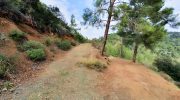
The journey begins on a wide, loose-surface gravel farm road. This first section covers approximately 1.5 kilometers of the hike. Because it is a repurposed rural access road, the terrain is quite even and poses very few technical challenges for walkers.
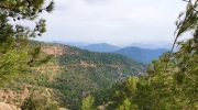
The road curves gently around the mountain slope, operating as an open-air balcony over the valleys below. This exposes hikers to unobstructed, wide-angle views of the sweeping ridges of the Machairas National Forest. On clear days, the visibility extends across the lower terrain of the Larnaca district, all the way to the Mediterranean coastline.
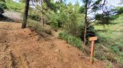
The Sheltered Woodland Single-Track
After the initial 1.5 kilometers on the open road, the trail conditions transition into a true nature path. The route narrows significantly into a single-file hiking track. This final leg covers about 750 meters and descends deeper into the mountain folds.
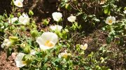
As you leave the exposed road behind, you step into a dense, shaded pine forest. The microclimate shifts almost immediately, becoming cooler and noticeably more fragrant with the scents of endemic mountain herbs and resinous trees. The terrain in this second leg features some moderate downhill slopes and uneven surfaces, with loose gravel and protruding rocks that require more careful attention to footing.
The Destination: Athasia Cave
The ultimate terminus of the linear trail is the fascinating Athasia Cave. The word Athasia translates directly to “Almond Tree” in the local Cypriot dialect. Near the entrance of the cave, you can still observe wild almond trees scattered among the dense pine forest, a unique combination that gave this specific mountain location its name.
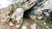
History of the Venetian Mine
The cave itself is not a natural geological formation but an ancient, narrow tunnel mine. Historical records indicate that the shaft was dug centuries ago during the Venetian rule of the island.
At the time, explorers were scouring the mineral-rich slopes of the Machairas range for deposits of copper and gold. The miners excavated a deep, horizontal tunnel straight into the rock face. Today, the tunnel remains an intriguing historical artifact of the island’s long history of mineral exploration.
Important Safety and Ecological Considerations
While the cave entrance is a rewarding historical landmark, modern visitors should adhere to several important safety rules:
- Bat Habitat Conservation: The unlit interior of the cave now serves as a quiet refuge for native bat colonies. Disturbing the darkness or making excessive noise at the mouth of the cave can disrupt their fragile ecosystem.
- Structural Safety: The ancient mining shaft is no longer structurally maintained. There are no internal supports or lighting, and the depth of the tunnel poses a potential hazard.
- Official Recommendation: For these reasons, hikers are strongly advised to enjoy the view of the cave entrance from the outside. Once you have reached the cave, the official nature trail ends, and you must make the return trek back up the path to reach your starting point.
Route Access and Parking Specifics
The trailhead is tucked away in the mountains but is accessible by regular motor vehicles during the dry season
Navigating to the Trailhead
To reach the starting point, hikers must drive through the village of Vavatsinia in the Larnaca region. From the center of the village, take the forest road that heads towards the Kionia picnic area. Follow the road uphill for exactly 3 kilometers.
As you approach the trailhead, look towards the right-hand side of the main road. The start of the trail is marked by an unpaved, loose-surface dirt road entrance.
Parking Options
Free parking is readily available right at the trailhead entrance. However, the parking area is quite small and can only accommodate a few cars at any given time. During the peak spring months of March and April, it is highly advisable to arrive early in the morning to secure a spot before local walking groups arrive.
Practical Guidelines for Hikers
Appropriate Footwear Choices
While the first segment of the hike follows a gentle and wide forest road, the second leg consists of a narrower, downhill nature trail. This single-track section contains loose gravel, uneven dirt, and small rocks that can become slippery. It is strongly recommended to wear sturdy hiking shoes or trail running shoes with reliable tread to prevent slipping on the descent.
Managing Your Water Supply
The Spilia Tis Athasias trail is a remote mountain path and is completely devoid of any infrastructure. There are no public water fountains, resting kiosks, or shops along the route. Every hiker must bring an adequate supply of drinking water, especially if visiting during the warmer late-spring months.
Family and Pet Suitability
The first 1.5 kilometers of the trail is exceptionally easy, flat, and wide. This specific segment is accessible for families with young children and even rugged outdoor strollers. The second leg down to the cave is narrower and steeper, requiring children to be supervised closely. The trail is also considered dog-friendly, provided your pet remains on a leash to respect local wildlife.


