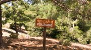
The Psilo Dentro trailhead sits at a high elevation near the village of Pano Platres. This specific route climbs toward the Pouziaris peak within the Troodos National Forest Park. It represents one of the most challenging paths for those who seek a steep ascent.
The air remains cool even as the summer heat affects the lower plains. Every kilometer provides a shift in the local flora and the ground texture. Tall pine trees dominate the start of the trek and provide vital shade. This mountain journey offers a direct look at the rugged heart of the island. It serves as a test for physical endurance and mental focus.
Trail Overview
- Location: Pano Platres, Troodos Mountains, Cyprus
- Distance: 5.6 miles (9 km)
- Route Type: Loop
- Difficulty: Hard
- Elevation Gain: 1,700 feet (520 meters)
- Duration: 3 – 4 hours
- Best Time to Visit: March to November
- Terrain: Rocky paths, loose soil, and forest floor
Technical Ascent and Path Elevation
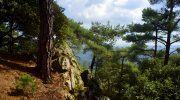
The climb starts at the Psilo Dentro restaurant area where the path enters the woods. One follows a narrow track that gains altitude with rapid pace. The incline stays consistent and demands steady effort from the legs. Loose rocks cover parts of the ground and require careful footwork.
This trail sits on a volcanic base of diabase and gabbro stone. These minerals create a dark and craggy look to the mountain side. The gradient stays steep until the route reaches the first ridge. This section tests the breath as the oxygen levels drop at higher altitudes.
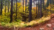
Forest Composition and Biodiversity
Black pine trees cover the slopes and survive the harsh winter snow. The golden oak also grows in the gaps between the larger pines. These oaks have thick leaves with a yellow tint on the underside. This feature helps the plant survive the intense sun of the Mediterranean.
No water sources exist on the higher parts of the ridge. The soil is dry and shallow which limits the types of plants that thrive. Rare orchids appear in the spring when the snowmelt provides brief moisture. Small bushes of sage and thyme scent the air as feet brush past them.
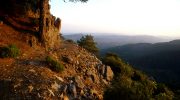
Navigation Along the Mountain Ridge
The path follows the spine of the mountain once the initial climb ends. This part of the trek offers a clear view of the surrounding peaks. One sees the summit of Mount Olympus to the north on a clear day. The track stays narrow with steep drops on either side. It is vital to maintain focus on the ground to avoid a fall.
The wind often picks up speed as the forest cover thins out. This breeze provides a welcome relief after the heat of the first climb. The lack of tall trees allows for a total view of the Limassol coastline.
Geological Features of the Pouziaris Peak
The rock formations at the top show the age of the Troodos range. Large boulders sit in balance on the edge of the cliffs. These stones contain minerals that formed deep under the ocean floor.
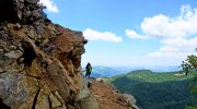
The peak itself is a bald area with very little shade. It offers a 360 degree perspective of the entire island. One can spot the salt lakes of the south and the northern range. The sun feels much stronger here because of the lack of canopy. A rest at the top allows the muscles to recover before the return walk.
Descent Strategy and Safety Steps
The return loop takes a different path back toward the start point. This descent is just as steep as the way up. The loose gravel makes the ground feel like marbles under boots. It is best to use a side step method on the most vertical parts. The pressure on the knees increases with every meter of drop.
One passes through areas of dense scrub that hide the local lizards. These reptiles bask on the warm stones during the midday hours. The path eventually rejoins the shade of the tall pines near the base.
Hydration and Supply Requirements
This trek demands at least two liters of water for each person. No kiosks or taps exist once the path leaves the trailhead. High energy snacks help maintain blood sugar during the three hour effort. A hat and sunscreen are mandatory for the exposed ridge sections. The weather can change in minutes at this altitude.
A light jacket is a smart addition to the pack even in summer. Proper hiking boots with ankle support prevent injury on the uneven rocks. One should inform someone of the plan before the start of the walk.
Path Maintenance and Signage
The Department of Forests manages the markers along the entire loop. Yellow paint on the rocks and trees indicates the correct route. Several junctions exist where other trails meet this path. It is easy to take a wrong turn if one does not watch the signs.
The trail stays in good condition despite the erosion from heavy rain. Small stone walls prevent the path from a slide down the hill. These efforts ensure that the route remains safe for the public. The trail stays clean because visitors follow a pack out rule.
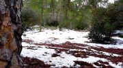
Seasonal Variations in Conditions
Winter brings ice and snow that can cover the trail markers. The route becomes dangerous without specialized gear like crampons. Spring is the peak time for a visit because of the mild climate. The flowers bloom and the grass stays green for a few weeks.
Summer offers a heat escape but the lack of shade on the ridge is tough. Autumn brings a change in the color of the golden oak leaves. The air becomes crisp and the visibility reaches its maximum. Each season provides a unique feel to the mountain landscape.


