The Troodos Mountains are one of the world’s clearest places to walk through ancient oceanic crust, preserved as an ophiolite and lifted above sea level in the centre of Cyprus. This exposed seafloor sequence helped scientists understand plate tectonics and later shaped Cypriot history by concentrating copper deposits, influencing climate, and supporting mountain settlement and tradition. This article explains how Troodos formed, how to “read” its layers across the landscape, and why the range connects deep geology with everyday life on the island.
- A Mountain Made from Seafloor
- Ninety Million Years, Now Visible
- Why the Layers Read So Clearly
- Why Troodos Changed How We Understand the Planet
- Copper Deposits Born from Seawater
- A Cooler, Greener Heart of the Island
- Faith, Craft, and Mountain Refuge
- Experiencing Troodos Today
- What Troodos Connects Together
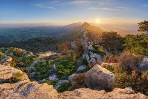
A Mountain Made from Seafloor
At first glance, Troodos looks like a typical Mediterranean highland: pine forests, winding roads, cool air in summer. What lies beneath, however, is extraordinary. The mountains are formed from an ophiolite, a complete slice of ancient oceanic crust and upper mantle that was pushed upward instead of sinking back into the Earth.
This makes the Troodos range one of the best-preserved and most accessible examples of oceanic lithosphere anywhere in the world. For geologists, it functions like a natural textbook laid open across the landscape. For visitors, it offers something rarer: the chance to stand on rocks that once formed the floor of a vanished ocean.
Ninety Million Years, Now Visible
The rocks of Troodos formed around 90 million years ago beneath the Neotethys Ocean. At that time, molten material rose from deep within the Earth, cooled, fractured, and erupted on the seafloor in a process similar to what happens today along mid-ocean ridges.
What makes Troodos unusual is what happened next. Instead of remaining submerged, tectonic forces slowly lifted this oceanic crust upward. Chemical reactions between seawater and mantle rocks reduced their density, helping the massif rise. Later, the collision of tectonic plates pushed the entire structure above sea level.
The result is a mountain range where the deepest rocks are found at the highest elevations, and younger marine sediments ring the flanks. It is an upside-down world by geological standards, and that inversion is precisely what makes Troodos so valuable.
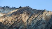
Why the Layers Read So Clearly
One of the reasons Troodos is so important is that its geological layers are still largely intact. Moving outward from the centre of the range, it is possible to trace the original structure of the ocean floor.
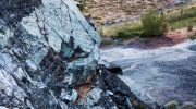
At the core are dense mantle rocks, once buried deep below the seabed. Above them lie the remains of magma chambers that fed volcanic activity. Higher still are vertical sheets of solidified magma that once acted as conduits to the surface. At the outer edges, rounded pillow lavas record eruptions into cold seawater, followed by fine marine sediments that settled quietly as volcanic activity faded.
Few places on Earth preserve this sequence so clearly or so accessibly.
Why Troodos Changed How We Understand the Planet
In the mid-20th century, Troodos played a critical role in confirming the theory of plate tectonics. Before direct ocean drilling was possible, scientists needed on-land evidence to understand how new crust forms beneath the sea.
The dense network of vertical volcanic dikes exposed in Troodos provided that proof. Their geometry showed that the crust had been pulled apart repeatedly and filled by magma, exactly as predicted by seafloor spreading models. What had once been theoretical became visible and measurable in stone, turning abstract concepts into physical reality.
Because of this clarity, Troodos remains a reference point for understanding modern ocean ridges and submarine volcanic systems, allowing scientists to interpret processes occurring deep beneath today’s oceans by studying what has already been lifted into view.
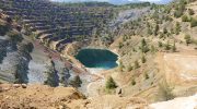
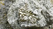
Copper Deposits Born from Seawater
The influence of Troodos geology extends far beyond academic study, reaching into the foundations of Cypriot history itself. As seawater once circulated through the hot oceanic crust, it dissolved and redistributed metals that later crystallised into copper-rich deposits. When these rocks rose above sea level, those minerals became accessible long before their geological origins were understood.
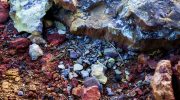
Early Cypriot communities learned to recognise and extract this copper, building an economy that connected the island to trade networks across the Mediterranean. Tools, weapons, and ingots moved outward from the mountains, while paths, settlements, and mining centres took shape within them. Even today, abandoned galleries, slag heaps, and scarred hillsides remain scattered across Troodos, quietly preserving the link between ancient industry and deep geological time.
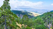
A Cooler, Greener Heart of the Island
Beyond mineral wealth, the elevation of the Troodos Mountains reshaped Cyprus’s climate and ecology. Rising above the surrounding plains, the range captures moisture, lowers temperatures, and creates conditions unlike anywhere else on the island. Snowfall in winter and cooler summers turned the mountains into a seasonal refuge, both for wildlife and for people escaping coastal heat.

This environment allowed forests to develop on mineral-rich soils, supporting endemic plant species adapted to conditions found nowhere else. Streams fed by winter snowmelt carry water toward lowland communities, reinforcing Troodos’s role as the island’s ecological engine rather than a distant backdrop.
Faith, Craft, and Mountain Refuge
The physical isolation of the mountains also shaped human settlement in quieter ways. During centuries marked by invasion and instability along the coast, communities retreated upward, using the terrain as protection. Over time, this isolation allowed distinctive traditions to endure with fewer interruptions.
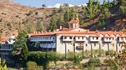
Painted churches emerged within modest stone structures, their interiors filled with layered cycles of Byzantine and post-Byzantine art. These frescoes were not decorative luxuries but expressions of continuity, belief, and identity shaped in places where time moved differently. Mountain villages developed crafts, architecture, and rhythms of life closely tied to climate and terrain, reflecting adaptation rather than resistance.
Experiencing Troodos Today
Today, Troodos is best understood not as a single attraction but as a landscape meant to be approached gradually. Winding roads reveal shifting rock types, forests open onto distant views, and small museums provide context without spectacle. Trails cross mantle rock and ancient lava, while village squares invite pause rather than haste.

Each season reveals a different aspect of the mountains. Spring and autumn offer clarity and balance, summer provides relief from coastal heat, and winter transforms the highest peaks into a rare snowy environment. In every case, the experience rewards patience, inviting visitors to notice change rather than consume scenery.
What Troodos Connects Together
The Troodos Mountains continue to matter because they bridge scales that are rarely connected. They link deep planetary processes with everyday human experience, showing how oceans form and vanish, how resources shape societies, and how people adapt to demanding landscapes over time.
Few places allow visitors to walk across the remains of an ancient ocean while stepping into living traditions shaped by that same ground. Troodos does not impress through grandeur alone. It reveals meaning slowly, through layers of stone, settlement, and memory, offering one of Cyprus’s most complete stories to those willing to read it carefully.