The Machairas to Lazanias Trail offers a distinct journey through the eastern peaks of the Troodos mountain range. This path connects the historic Machairas Monastery with the traditional village of Lazanias. It serves as a vital corridor for those who wish to observe the transition from deep forest to rural stone architecture.
The air in this region stays fresh and carries the scent of wild thyme and dense pine needles. Travelers notice a rugged landscape that reflects the ancient geological shifts of the island. This specific route provides a home to many rare plants that flourish in the volcanic soil of the area.
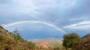
Each section of the track reveals a new perspective of the deep valleys and the rocky ridgelines. The path follows the natural flow of the mountain side to offer a steady pace for the hiker. It represents a perfect harmony of natural beauty and historical heritage for every visitor who seeks a quiet escape.
Trail Overview
- Location: Machairas Forest, Nicosia District
- Distance: 3.4 miles (5.5 km)
- Route Type: Linear
- Difficulty: Moderate
- Elevation Gain: 820 feet (250 meters)
- Duration: 2 – 2.5 hours
- Best Time to Visit: March – May
- Terrain: Rocky and Dirt Path
Botanical Diversity and Local Forest Health
The Machairas to Lazanias Trail sits within a dense forest of Calabrian pine trees. These evergreens dominate the slopes and provide a thick canopy for the first half of the route. This shade is essential for the survival of smaller shrubs that grow in the dry mountain earth. The golden oak of Cyprus also appears in large numbers near the shaded gullies. This tree has leaves that look dark green on top and bright yellow on the underside. The mix of these two species creates a stable forest floor that stays green throughout the entire year.
Under the tall trees the wild flora thrives in the mineral rich soil. Flowers like the Cyprus orchid and the rock rose bloom in abundance during the spring months. These plants depend on the moisture that remains in the earth after the winter rains. The trail also features a variety of aromatic herbs such as sage and lavender. These plants add a pleasant scent to the air and support a wide range of local insects. The biodiversity of the Machairas forest makes it a top site for botanical study and forest conservation. Every step on the path offers a new fact about the resilience of mountain plants in a dry climate.
Geological Features and Mountain Formation
The terrain of the Machairas region is a subject of great interest for geologists across the world. This area is part of an ancient sea floor that rose to the surface millions of years ago. The rocks along the trail consist mainly of pillow lavas and diabase formations. These stones have a dark color and a very dense structure that resists the effects of time and weather. The soil is thin in many places which forces the tree roots to search deep for a solid anchor. This creates a rugged look that defines the eastern Troodos landscape.
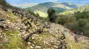
The path moves across several steep ridges that offer a clear look at the layers of the earth. These rock formations tell a story of the volcanic activity that formed the core of the island. Rainwater and snowmelt collect in small channels and flow toward the Pedieos river. This water source is vital for the health of the trees and the animals that live in the valley. The mineral content of the rock affects the type of vegetation that can survive in each section. This geological variety is why the area remains a protected part of the national forest park. The stability of the rock makes the walk feel secure even on the steeper sections of the track.
Avian Life and High Altitude Wildlife
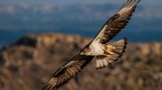
Birds are the most visible form of wildlife along this peaceful mountain track. The endemic Cyprus wheatear often sits on the rocky outcrops to watch for small insects. This bird prefers the open spaces near the village of Lazanias where the forest begins to thin out. The masked shrike and the coal tit also move through the pine branches in search of food. Their presence adds a layer of natural sound to the quiet environment of the mountain side. Large birds of prey like the Bonelli eagle occasionally circle in the sky far above the ridgelines.
Mammals are harder to spot but they leave many signs along the dirt path. The Cyprus mouflon is the most famous animal of the region although it stays far from the main route. This wild sheep has a thick coat and strong legs that help it move across the loose stones. Tracks of the red fox often appear in the dust after a light rain in the early morning. These predators play a key role in the balance of the ecosystem within the Machairas forest. The lack of human noise allows these animals to move with more freedom in this secluded zone. The trail allows a brief look into a world where nature remains in its original state.
Historical Context and Cultural Heritage
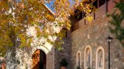
The Machairas Monastery stands as a massive monument at the start of the trail. It has a long history that dates back to the twelfth century and serves as a spiritual hub. The monks here have managed the land and the forests for hundreds of years with great care. The trail to Lazanias was once a primary route for people who traveled between the monastery and the nearby villages. These locals relied on the path to transport goods and to visit family members. Today the Department of Forests maintains the route to preserve this piece of cultural history.
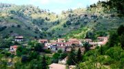
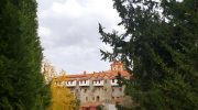
Stone ruins and old terraces still stand as silent witnesses to the past along the path. These structures show how the people of the mountains shared the land and its limited resources. The village of Lazanias is a perfect example of traditional mountain architecture with its stone walls and narrow streets. It feels like a place where time stops and the modern world fades away into the background. The trail provides a link to a time when life was much slower and tied to the cycles of the sun. Forestry experts now use the route to educate the public about the importance of heritage and nature. This historical connection makes the walk feel much deeper than a simple exercise in the woods.
Path Conditions and Navigation Guidelines
The surface of the Machairas to Lazanias Trail is a mix of packed earth and sharp volcanic rock. This requires a decent level of focus and the use of sturdy boots with a good grip. The path is well marked with signs that provide directions and facts about the local plants. Some sections are quite narrow as they follow the edge of the deep mountain valleys. These areas offer some of the best views of the eastern peaks and the plains toward Nicosia. The steady elevation gain makes for a good physical challenge for the average walker.
Maintenance teams clear the path after the winter storms to ensure that it remains safe for everyone. It is important to stay on the marked track to avoid damage to the rare wildflowers. The sun can be very strong on the open sections of the ridge so a hat is a necessary item. There are no water taps along the route once the traveler leaves the monastery grounds. Every hiker must carry a full supply of water to stay hydrated during the climb. This preparation allows for a stress free experience in one of the most beautiful parts of the island. The trail design respects the natural contours of the land and avoids any harsh impact on the soil.


