Cyprus offers some of the most beautiful coastal paths in the Mediterranean region. The trail from Konnos Beach to Agioi Anargyroi stands out as a prime example of natural beauty. This path winds along the rugged cliffs of the Cape Greco National Forest Park. Hikers enjoy a direct view of the turquoise sea while they walk on ancient limestone formations.

The air smells of salt and wild thyme throughout the entire journey. Every step reveals a new perspective of the coastline. This route connects two iconic landmarks and provides a peaceful escape for nature lovers. It represents the raw, untouched spirit of the Cypriot landscape.
Trail Overview
- Location: Cape Greco National Forest Park, Ayia Napa, Cyprus
- Distance: 3 miles (4.8 km)
- Route Type: Point-to-Point (can be done as Out & Back)
- Difficulty: Easy
- Elevation Gain: 40 meters
- Duration: 1 – 1.5 hours
- Best Time to Visit: September to May or at Sunrise
- Terrain: Rocky, Coastal, and Limestone paths
The Path Along the Azure Coast
The journey begins at the scenic Konnos Bay. This area serves as a gateway to the Cape Greco peninsula. You start the walk on a well-defined track that hugs the edge of the cliff. The trail remains mostly flat which makes it accessible for most fitness levels. To your left, the Mediterranean Sea stretches toward the horizon in shades of deep blue. The sun reflects off the water and creates a bright glare on clear days.
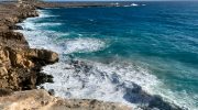
You should wear a hat and sunscreen because the path has very little shade. The limestone under your feet feels solid but occasionally uneven. Small lizards often dart across the rocks as you pass. Local flora like the Phoenician juniper and wild shrubs line the sides of the walkway. These plants survive in the harsh, salty environment and stay green all year.
Geological Wonders and Sea Caves
As you move further south, the geology of the area becomes more dramatic. The waves have carved intricate shapes into the soft rock over thousands of years. You will see several spots where you can stop to admire these natural sculptures. One highlight of this section is the proximity to the sea caves. These hollow structures sit just below the cliff edge.
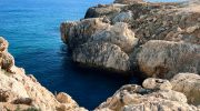
Some hikers choose to descend small paths to see the caves from a closer angle. The sound of the waves crashes against the stone and echoes through the air. It is a rhythmic noise that follows you for much of the trek. You notice how the white stone contrasts with the dark blue water. This visual contrast is a signature feature of the southeastern coast of Cyprus.
The Famous Kamara tou Koraka
A significant landmark on this route is the Kamara tou Koraka. This is a natural stone bridge that once allowed people to walk across a deep gap. Today, a fence surrounds the structure to protect it from further erosion. The bridge looks fragile but still showcases the power of natural forces.
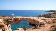
It is a popular spot for photographs because of its unique arch shape. You can stand nearby and marvel at how nature creates such delicate balance. The trail continues past this point toward the Agioi Anargyroi chapel. You feel a light breeze from the sea which helps cool the temperature. The path remains easy to follow with clear markers at regular intervals.
Arrival at Agioi Anargyroi Chapel
The trail concludes at the white and blue chapel of Agioi Anargyroi. This small church sits on a pedestal of rock above the ocean. It represents the traditional Greek Orthodox style of architecture. Many visitors find the site peaceful and stop here to rest. Beneath the chapel, a set of stairs leads down to a hidden sea cave.
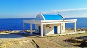
This cave often holds a small altar and icons. People believe the water here has special properties. Nearby, the Blue Lagoon offers a place for a swim. The water in the lagoon is exceptionally clear and shallow. Many boats anchor here so their passengers can dive into the sea. You can sit on the rocks and watch the boats bob on the gentle waves.
Practical Tips for the Hike
- You must bring enough water for the entire trip. There are no shops or taps once you leave the start point.
- Sturdy shoes are better than flip-flops because the rocks can be sharp. If you walk during the summer, start as early as possible.
- The heat in Cyprus becomes intense by midday. You can catch a bus back to your hotel from the main road near the chapel.
- Alternatively, you can walk back the same way to see the views from the opposite direction. This trail provides a great way to experience the biodiversity of the island.


