The Loumata ton Aeton Nature Trail provides a detailed look at the rugged beauty of the Limassol district. This path winds through the heart of the Amiantos region within the Troodos National Forest Park. It offers a unique window into the geological and botanical wealth of the island.

Every section of the track reveals a landscape that remains wild and largely untouched by modern life. The air stays fresh and carries the scent of pine and wild herbs throughout the seasons. This specific environment supports a wide array of rare plants that thrive only in this mountain climate.
History and nature merge along this route as it follows the path of old mountain streams. The terrain shifts from dense woods to open ridges with vast views of the surrounding peaks. It serves as a vital destination for those who seek a profound connection with the earth.
Trail Overview
- Location: Amiantos, Limassol District
- Distance: 1.5 miles (2.5 km)
- Route Type: Linear
- Difficulty: Moderate
- Elevation Gain: 492 feet (150 meters)
- Duration: 1 hour
- Best Time to Visit: March – May
- Terrain: Rocky and Forest Floor
Botanical Diversity and Local Plant Life
The Loumata ton Aeton Nature Trail hosts a vast collection of flora that defines the mountain zone of the island. The Pinus brutia or Calabrian pine dominates the lower sections of the route. This tree is very resilient and survives well in the rocky soil of the Troodos range. Beneath the tall pines the golden oak of Cyprus creates a thick and vibrant understory. This oak species is endemic to the island and features leaves with a yellow tint on the underside.
Wildflowers appear in great numbers when the winter snow melts from the high peaks. The Cyprus crocus and the Troodos violet often bloom near the edge of the dirt path. These plants rely on the high moisture levels found in the shaded gullies of the Amiantos region. The scent of wild lavender and sage fills the air as the sun warms the mountain side. This rich variety of plants makes the trail a top site for botanical study and nature photography.
Geological Features
The geology of the Loumata ton Aeton area is a subject of intense interest for experts across the globe. This trail moves over rocks that formed on the ocean floor millions of years ago. The terrain consists mainly of ophiolite rocks such as gabbro and diabase. These stones have a dark color and a very dense structure that resists the effects of weather. The soil is thin and full of minerals that support the growth of rare mountain species.

Tectonic forces pushed these rock layers high into the atmosphere as the island rose from the sea. Hikers see exposed cliffs where the layers of the earth are visible to the naked eye. These formations tell a story of the heat and pressure that shaped the core of the mountain range. Small streams cut through the rock to form narrow valleys known locally as loumata. This term refers to the natural basins where water collects after a heavy rainstorm. The geological history of the trail provides a solid base for the entire mountain ecosystem.

Avian Species and Mountain Wildlife Habitat
Birds find a perfect refuge within the dense pine forests of the Loumata ton Aeton Nature Trail. The endemic Cyprus warbler often nests in the thick shrubs near the water sources. This bird is a common sight as it moves quickly between the branches in search of food. The coal tit and the short-toed treecreeper also call this rugged terrain their home. Their calls are often the only sound that breaks the silence of the mountain valley. These species are vital for the health of the forest as they help to control insect populations.

Larger animals like the Cyprus mouflon inhabit the steeper slopes far above the main path. These wild sheep are extremely shy and avoid any contact with humans. Their tracks occasionally appear in the soft mud near the seasonal streams. Foxes and hares also live in the area and find shelter among the rocks and the thick brush. The presence of these animals indicates that the habitat is stable and well protected by law. The trail offers a rare chance to observe wildlife in a state of total balance with the environment.
Historical Significance and Local Heritage
The Amiantos region has a long history that is tied to the mineral wealth of the mountains. People once worked in nearby mines to extract asbestos which was a major industry for the island. The Loumata ton Aeton Nature Trail follows the same paths that workers used to reach their sites. These tracks became part of a larger network that connected mountain villages with the coastal towns. Today the focus has shifted toward the restoration of the land and the protection of the forest.

The Department of Forests works hard to maintain the trail and to preserve the old stone walls. These structures show how the people of the past managed the land to prevent erosion. The trail serves as a bridge between the industrial history of the region and the modern goal of conservation. It allows visitors to reflect on the relationship between human labor and the natural world. The quiet of the woods now covers the sites where heavy work once took place. This historical context adds a deep layer of meaning to every walk along the mountain path.
Path Conditions and Navigation Protocol
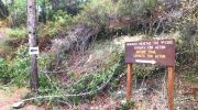
The surface of the Loumata ton Aeton Nature Trail is a mix of firm earth and loose gravel. This requires a decent level of focus and the use of sturdy footwear with good grip. The path is well-marked with signs that provide information about the distance and the terrain. Some sections are narrow as they move along the side of the steep gullies. These areas offer some of the best views of the Troodos peaks and the valleys below.
Maintenance teams clear the path after the winter months to ensure that it remains safe for everyone. It is important to stay within the marked boundaries to protect the rare plants. The elevation gain is steady which makes for a good physical workout without extreme stress. There are no water taps along the linear route so hikers must carry a full supply. This preparation ensures that the focus remains on the beauty and the facts of the forest. The trail design respects the natural flow of the mountain side and avoids any harsh impact on the ground.
Seasonal Variations and Climate Observations
Spring is the most vibrant time to explore the Loumata ton Aeton Nature Trail. The water in the streams flows with force as the snow melts from the higher altitudes. This moisture triggers a burst of life among the ferns and the mosses in the shade. Summer offers a cool escape when the heat in the cities becomes too intense for comfort. The shade of the pine canopy provides a natural shield from the rays of the sun.

Autumn brings a shift in the color of the forest as the golden oak turns to shades of bronze. The air becomes crisp and the visibility across the island increases on clear days. Winter often covers the Amiantos region in a thin layer of frost or snow. The dark rocks stand out sharply against the white ground during the cold months. Each season provides a different look at the same landscape and its diverse life forms. The cycle of the seasons is a key part of the experience for every visitor.


