
The Mountiko Nature Trail, also frequently spelled Moundiko, is one of the Mediterranean’s best-kept hiking secrets. Located in the Paphos District of Cyprus, this trail offers an immersive journey through the island’s unique ecology. Winding around the outskirts of the traditional village of Kathikas, it sits on the threshold of the Akamas Peninsula, a protected wilderness area renowned for its biodiversity.
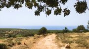
The trail bridges the gap between rugged, dramatic gorges and tranquil agricultural landscapes. Hikers are treated to sweeping views of the Mediterranean Sea, sweeping pine forests, and limestone cliffs. Whether you are an avid trekker or a casual nature enthusiast, the trail promises a rich sensory experience that captures the wild, untamed spirit of Cyprus.
Mountiko Nature Trail Overview
- Location: Just west of Kathikas Village, Paphos District, Western Cyprus.
- Distance: Approximately 9 to 11 kilometers (roughly 5.5 to 6.8 miles).
- Route Type: Circular / Loop.
- Difficulty: Moderate (some steep inclines and declines).
- Elevation Gain: Approximately 373 meters (around 1,224 feet).
- Duration: Between 3 to 4 hours at a steady pace.
- Best Time to Visit: Spring (February to April) for peak wildflowers, or autumn for cooler weather.
- Terrain: Predominantly gravel tracks and dirt paths with some rocky stretches, limestone surfaces, and red clay paths.
The Geography and Setting of Kathikas
To fully appreciate the Mountiko Nature Trail, one must understand its unique geographic position. Kathikas sits at an altitude of approximately 650 meters above sea level. This elevation grants the region a distinct microclimate. It is noticeably cooler and less humid than the coastal areas of Paphos, making it an ideal destination for outdoor activities even during the warmer months of the year.
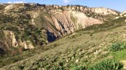
The trail itself loops around the Moundiko Plateau. It is strategically situated between two major geographical features: the Farkonias Gorge to the north and the Koufon (also known as Erini) Gorge to the south. These deep ravines have carved their way through the limestone bedrock over millions of years, creating a dramatic landscape of steep drops and jagged rock formations. Walking along the edge of these gorges provides hikers with striking panoramic views that stretch all the way to the Chrysochou Bay and the Akamas coastline.
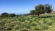
The soil in this area is predominantly calcareous, which has given rise to a very specific type of flora. It also makes the surrounding land exceptionally fertile for viticulture. As you walk the initial stretches of the trail, you will pass through ancient vineyards that have been cultivated by the local villagers for generations. This harmonious blend of wild nature and traditional agriculture defines the first segment of the hike.
Flora and Fauna Along the Trail
The Mountiko Nature Trail is a haven for biodiversity, particularly during the spring months. The region is covered in maquis and phrygana—the typical scrubland vegetation of the Mediterranean. These plants have adapted perfectly to the long, dry summers of Cyprus, releasing aromatic oils that fill the air with the scents of wild thyme, rosemary, sage, and lavender.

As the trail descends toward the deeper parts of the valleys, the vegetation changes. Dense stands of Calabrian pine (Pinus brutia) and Phoenician juniper (Juniperus phoenicea) provide welcome shade. In the more humid sections near the seasonal streams, you can find oriental plane trees (Platanus orientalis) and oleanders, which bloom in vibrant pinks and whites during the early summer.
For botanists and wildflower enthusiasts, the trail is most spectacular between February and April. This is when the ground comes alive with a colorful carpet of anemones, cyclamens, and wild gladioli. Most notably, the trail is home to several species of wild orchids, some of which are endemic to Cyprus.

The diverse plant life supports a rich variety of wildlife. Birdwatchers should bring binoculars, as the cliffs of the nearby gorges are nesting sites for several birds of prey. You may spot the majestic Bonelli’s eagle soaring overhead, or the long-legged buzzard scanning the scrub for food. The trail is also an excellent place to observe the Cyprus warbler and the Cyprus wheatear, two species that are completely unique to the island. On the ground, you might catch a glimpse of the large but harmless starred lizard basking on the warm limestone rocks.
Detailed Walkthrough and Trail Logistics
The Mountiko Nature Trail is a circular route, meaning hikers will end exactly where they began. The total length of the trail ranges between 9 and 11 kilometers, depending on whether you take certain short detours to viewpoints. The hike typically takes between three to four hours to complete at a moderate pace, allowing ample time for photography and rest.
Starting Point and Initial Ascent
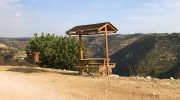
The most common starting point is located just west of the Kathikas village center. There is a small dirt parking area marked by an official forestry department signpost. From here, the trail begins as a gentle dirt track that winds past dry-stone walls and old vineyards. The walking is easy here, allowing hikers to warm up their legs while enjoying the open countryside views.
Entering the Gorge and the Midpoint
About two kilometers into the walk, the terrain begins to change. The wide track narrows into a single-file footpath as it begins to trace the upper rim of the Farkonias Gorge. This section requires more concentration, as the trail is rocky and uneven underfoot. The views here are spectacular, looking down into the deep, green chasm below.
The midpoint of the trail is marked by a steep but rewarding descent into the valley floor. Here, hikers cross a dry streambed that flows only during the winter rains. This is the lowest point of the trail and offers a complete change of perspective; instead of looking down into the gorge, you are surrounded by towering limestone cliffs. There are several flat boulders in this area that serve as the perfect spot for a halfway picnic.
The Return Loop and Ascent
The return leg of the loop involves a steady, moderate ascent back up toward the Moundiko Plateau. This section has a switchback design to make the elevation gain manageable. As you climb higher, the ocean comes back into view on the horizon. The final two kilometers flatten out, merging back into the agricultural paths that lead directly back to the Kathikas trailhead.
Practical Tips for Hikers
To ensure a safe and enjoyable experience on the Mountiko Nature Trail, proper preparation is essential. The trail is rated as moderate in difficulty. While it does not require technical mountaineering skills, it does involve significant elevation changes and rough, rocky terrain that can be challenging for those without hiking experience.
- Footwear: Sturdy hiking boots or trail running shoes with good grip are mandatory. The limestone rocks can be slippery when wet, and the gravel paths require solid ankle support.
- Hydration and Food: There are no water sources or facilities along the trail. Hikers must carry at least two liters of water per person, especially during the warmer months. High-energy snacks like nuts, dried fruit, or sandwiches are highly recommended.
- Sun Protection: Much of the trail is completely exposed to the sun. Even in the spring, the Mediterranean sun can be intense. Hikers should wear a wide-brimmed hat, apply high-SPF sunscreen, and wear lightweight, long-sleeved clothing.
- Timing: The best time to start the hike is early in the morning. This allows you to complete the most strenuous sections before the peak heat of the day. In the winter, make sure to check the sunset time, as the gorges get dark quickly once the sun drops behind the hills.


