The path to nature offers a cure for the soul. Hidden in the Larnaca District stands the village of Delikipos. This spot remains a secret to many and keeps a quiet charm. Travelers seek this place for the fresh air and the green views. The route provides a chance to escape the city noise. You find peace here.

The journey takes you through a land of pine and stone. Green trees cover the hills and offer shade from the sun. A hike here feels like a step back in time. The air smells of wild thyme and earth. Visitors love the calm mood of the forest. It serves as a perfect retreat.
This trail is a gem for those who love the outdoors. The walk is not hard but offers great rewards. You see water and wildlife along the way. The path loops around and brings you back to the start. It is a short trip but full of beauty. Nature lovers value this special site.
Trail Overview
- Location: Delikipos Village, Larnaca District
- Distance: 1.8 miles (2.9 km)
- Route Type: Loop
- Difficulty: Easy to Moderate
- Elevation Gain: 270 feet (82 meters)
- Duration: 1 to 1.5 hours
- Best Time to Visit: March to May or October to December
- Terrain: Dirt Roads and Forest Paths
The Village Context
Delikipos sits in a green valley and boasts a rich past. The population is small and keeps the area quiet. Few people live here and this preserves the calm vibe. The land has a history of agriculture. Farmers grew olives and grain here for ages. You can still see old olive trees that date back centuries. These trees stand as proof of the village’s deep roots.
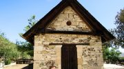
The heart of the village holds a historic treasure. The Church of the Transfiguration of the Savior stands tall. Builders constructed this holy site in 1726. It features classic style and art. Locals take pride in this landmark. It adds a touch of culture to the natural beauty. The structure invites you to pause and admire the craft.
The Route Description
The adventure begins near the church. A clear path leads you away from the paved roads. You step onto the dirt track and feel the crunch of earth underfoot. The route winds through the tall pine trees. These trees provide a cool canopy above. Sunbeams filter through the branches and dance on the ground.

The trail follows a gentle slope. It does not require great fitness to complete. Families often walk here together. The path is wide enough for a comfortable stroll. You move deeper into the woods and the sounds of cars fade away. Only the sounds of nature remain. The route guides you toward the water and the dam.
The Gabion Water Barrier
A key feature of this hike is the Gabion Dam. Workers built this structure in 2008. They used wire baskets filled with rocks. This method allows the dam to blend with the land. It holds back water to create a small lake. This water source helps the local farmers. It also draws wildlife to the area.
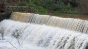
The dam sits in a scenic spot. Water reflects the blue sky and the green hills. Ducks often swim across the surface. Frogs call out from the reeds at the edge. Visitors stop here to rest and take photos. Benches offer a place to sit and watch the view. The sight of the water brings a sense of calm. It is a highlight of the trip.
The Stone Arch and Stream
The trail also leads to a famous double stone bridge. This landmark connects the banks of the river. Its design suggests it comes from the Venetian era. The stone work is solid and has stood the test of time. It fits perfectly into the landscape. The bridge looks like a scene from a storybook.
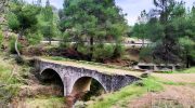
Water flows under the arch after the rain. A small waterfall forms here in the wet season. The sound of the water creates a soothing rhythm. This spot is popular for pictures. The mix of stone and water and trees looks grand. You can walk across the bridge and view the stream from above. It connects you to the history of the land.
Flora and Wildlife
The forest of Delikipos teems with life. The Cyprus pine is the main tree here. Its needles scent the air. You also find the Golden Oak on these hills. This tree is the national tree of the island. It adds diversity to the green cover. Wild shrubs like thyme and rock rose grow near the path. They add bursts of color in the bloom season.
Animals also call this place home. You might spot a hare or a fox if you are quiet. Birds fill the trees with their songs. The Cyprus Warbler is a common sight. Partridges also roam the brush. The dam attracts water birds and amphibians. Nature enthusiasts enjoy the chance to observe these creatures. The area supports a healthy ecosystem.
Seasonal Variations
The landscape changes with the seasons. The months from March to May offer the best views. Flowers bloom and paint the ground with color. The weather is mild and perfect for a walk. The water flows strong in the streams. This time of year brings the forest to life.
The cooler months of late year are also good. The heat of the summer fades. The air turns crisp and fresh. Rains refill the dam and the river. The greens turn deep and lush. Summer can be hot and dry. The water levels drop low. Most hikers prefer the cooler days for this route.
Geological Features
The ground beneath you tells a story of the earth. The area sits near the Ophiolite complex. This rock formation comes from the ocean floor. It rose up millions of years ago. You walk on sedimentary rocks and ancient lava flows. The soil is rich and supports the dense plant life.

The terrain varies from soft earth to rocky patches. The path is mostly smooth but has some uneven spots. Good shoes help you grip the ground. The hills roll gently and do not have steep drops. The land feels stable and safe. You feel the solid earth with every step.
Practical Information
Access to the trail is simple. You can park your car near the church in the village. There is ample space for vehicles. The trail head is easy to find. Signs mark the way and keep you on track. You do not need a guide to follow the route.

Wear sturdy shoes for the walk. The dirt path can get muddy after rain. Carry water to stay hydrated. No shops exist on the trail itself. Keep the area clean and take your trash with you. This protects the nature for others. Respect the quiet of the woods.
Conclusion!
A visit to Delikipos offers a break from routine. The trail provides a mix of history and nature. You see the dam and the bridge and the trees. The walk clears the mind and lifts the spirit. It is a simple pleasure that costs nothing. You leave with a fresh outlook. This village proves that beauty hides in small places. You do not need to travel far to find peace. The forest waits for you. The path is ready. Take the time to explore this hidden corner of Cyprus. It welcomes you with open arms.


