Explore Cyprus with Our Interactive Map

Explore our top stories and discover ideas worth your time.

Livadi Trail

Livadi Trail

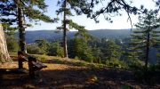
The Livadi Trail offers a serene path through the heart of the Troodos mountains. This route showcases a unique side of the island that few visitors see. It provides a peaceful escape into the cool mountain air far from the crowded beaches. The path winds through a flat plateau that hosts rare plant life. Massive black pines tower above the track and offer deep shade. This specific environment supports a delicate ecosystem that remains green throughout the entire year. Accessibility makes this location a favorite for those who want a gentle walk. The trail design accommodates people of all ages and fitness levels. Every section of the loop reveals a new perspective of the surrounding peaks and valleys. Trail Overview Location: Troodos National Forest Park Distance: 1 mile (1.5 km) Route Type: Loop Difficulty: Easy Elevation Gain: 33 feet (10 meters) Duration: 45 minutes Best Time to Visit: May – October Terrain: Paved and Flat Forest Floor Botanical Features and Rare Forest Species The Livadi Trail sits at an altitude of seventeen hundred meters above the sea level. This height creates a specific climate that favors the growth of the Pinus nigra or black pine. These trees can reach ages of over five hundred years within the Troodos range. Their thick bark protects them from the cold winters and the…

Read more
Ayia Napa Lover’s Bridge

Ayia Napa Lover’s Bridge

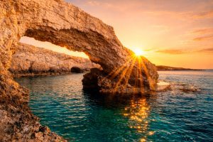
The Lover's Bridge stands as one of Cyprus's most photographed natural landmarks. This limestone arch extends from the coastal cliffs near Ayia Napa, reaching toward the Mediterranean Sea with one end firmly anchored to land while the other dips into crystal-clear turquoise water. The bridge measures approximately 6 meters long and half a meter wide, formed entirely through natural processes without any human construction. Visitors from around the world come to walk across this slender natural formation, particularly during sunset hours when golden light transforms the white limestone and azure water into a scene of remarkable beauty. The bridge takes its name from romantic traditions that have developed around the site. Local legend claims that couples who kiss while standing in the middle of the arch and make a wish together will see their wishes come true. This belief has made the location a popular destination for marriage proposals, wedding photographs, and symbolic ceremonies celebrating love and commitment. How Wave Action Sculpted the Arch The Lover's Bridge formed through a combination of mechanical and chemical erosion acting on limestone bedrock. Rainwater absorbs carbon dioxide from the atmosphere and soil, creating a weak carbonic acid solution. When this slightly acidic water contacts limestone, it triggers chemical reactions that gradually dissolve the calcium carbonate rock. Seawater contains additional dissolved salts and compounds…

Read more

Smigies Nature Trail

Smigies Nature Trail

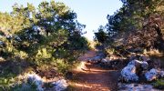
The Smigies Nature Trail lies within the heart of the Akamas Peninsula near the village of Neo Chorio. This route follows a scenic path that overlooks both the west and north coasts of the island. A soft breeze from the Mediterranean Sea cools the air during the spring months. Every step along the dirt track reveals a new perspective of the rugged shoreline. The forest consists of dense juniper and mastic trees that provide a natural scent. This trek serves as a prime example of the coastal biodiversity in Cyprus. It offers a calm retreat for those who seek a walk through nature. Trail Overview Location: Neo Chorio Village, Cyprus Distance: 3.1 miles (5 km) Route Type: Loop Difficulty: Moderate Elevation Gain: 540 feet (165 meters) Duration: 2 hours Best Time to Visit: January to May Terrain: Dirt tracks, rocky paths, and forest floor The Start at Smigies Picnic Site The journey begins at the Smigies picnic area where ample parking exists for visitors. This spot serves as a central hub for several paths within the Akamas Forest. One find benches and clean water taps near the trailhead for convenience. The path moves away from the picnic tables and enters a thicket of shrubs. Local flora like the rockrose and wild sage line the edge of the track. The ground…

Read more