
The Vasa Kilaniou Trail represents a significant cultural and natural landmark within the Limassol district of Cyprus. This path winds through a region famous for its deep viticultural roots and traditional stone architecture. Travelers who walk this route encounter a unique blend of botanical diversity and historical remnants that define the rural Cypriot experience.
Every step along this path reveals a story of the past and the present. The surrounding hillsides showcase a landscape that local farmers have nurtured for several centuries. This specific area remains a vital part of the island’s heritage because it connects modern visitors with ancient agricultural practices.
The trail serves as an educational resource for those who value quiet reflection and botanical study. It provides a peaceful escape from the busy coastal cities while highlighting the raw beauty of the Mediterranean interior. This environment fosters a deep appreciation for the quiet rhythm of village life and the resilience of the natural world.
- Trail Overview
- The Geographical Context of Vasa Kilaniou
- Cultural Heritage and Local History
- Botanical Diversity Along the Path
- Viticulture and the Wine Tradition
- Architectural Features of the Trail
- Wildlife and Fauna Observations
- Geological Formations and Soil Composition
- Seasonal Changes and the Best Time to Hike
- Practical Tips for a Successful Walk
- Connectivity to the Village Life
Trail Overview
- Location: Vasa Kilaniou Village, Limassol District, Cyprus
- Distance: 2.5 miles (4 km)
- Route Type: Loop
- Difficulty: Easy to Moderate
- Elevation Gain: 150 meters
- Duration: 1.5 – 2 hours
- Best Time to Visit: March to May OR September to November
- Terrain: Dirt paths and rocky limestone tracks
The Geographical Context of Vasa Kilaniou
Vasa Kilaniou sits at an altitude of approximately 750 meters above sea level within the southern slopes of the Troodos mountain range. This elevation creates a climate that supports both Mediterranean scrub and temperate fruit trees. The village itself holds a reputation as one of the primary wine-producing hubs in the Krasochoria region.
The name of the village likely stems from its position at the base of the surrounding hills. Geology plays a massive role in the trail’s appeal because the limestone soil provides the perfect foundation for the local flora. Visitors often notice the white rock formations that contrast sharply against the green foliage. This natural canvas makes the walk visually striking throughout the year.
Cultural Heritage and Local History
History permeates every inch of the Vasa Kilaniou Trail. The village once stood as the center of the local community during the Byzantine and Ottoman periods. As you walk, you pass by old stone structures that served as shelters for shepherds and farmers. These buildings reflect the traditional masonry techniques that utilize local stone without the need for modern mortar.
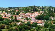
The trail also nears several chapels that date back many decades. These religious sites offer a glimpse into the spiritual life of the rural population. Many residents still maintain the vineyards that line the path today. Their commitment to the land ensures that the trail remains a living museum of Cypriot rural culture.
Botanical Diversity Along the Path
The flora of the Vasa Kilaniou Trail is diverse and changes with the seasons. During the spring months, the ground erupts with a variety of wildflowers such as anemones and orchids. These plants thrive in the alkaline soil of the Limassol hills. Oak trees and carob trees provide intermittent shade along the route.
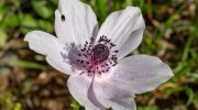
Carob trees once earned the title of “the black gold of Cyprus” due to their immense economic value. Their presence today serves as a reminder of the island’s trade history. Aromatic herbs like thyme and oregano grow wild along the edges of the path. The scent of these herbs fills the air and creates a sensory experience that defines the Mediterranean landscape.
Viticulture and the Wine Tradition
Wine production is the heartbeat of the Vasa Kilaniou region. The trail offers a direct view into the ancient terraced vineyards that climb the steep slopes. These terraces prevent soil erosion and maximize the limited rainfall that the area receives. Local grape varieties like Xynisteri and Mavro dominate the fields.
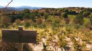
These grapes produce the famous wines of the region, including the sweet dessert wine known as Commandaria. The trail provides an opportunity to observe the seasonal cycle of the vines. In the winter, the vines look like gnarled wood. By summer, they transform into lush green blankets of leaves. This cycle dictates the pace of life for many people who live in the village.
Architectural Features of the Trail
The trail features several points of interest that highlight the architectural skill of the past. One significant feature is the presence of old wine presses known as “linos.” These stone structures allow us to understand how people processed grapes before modern machinery existed. The craftsmanship involved in these presses is remarkable because it shows a deep understanding of physics and gravity.
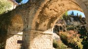
The path also crosses small stone bridges that span seasonal streams. These bridges demonstrate the importance of connectivity in the rural landscape. Even the simple stone walls that line the path serve a purpose as they mark property boundaries and protect the soil. These features contribute to the overall aesthetic value of the walk.
Wildlife and Fauna Observations
While the flora is prominent, the fauna of the Vasa Kilaniou Trail is equally noteworthy. Birdwatchers often frequent this area to spot local species like the Cyprus wheatear or the Cyprus warbler. These birds find refuge in the dense thickets and old trees. Lizards often bask on the warm limestone rocks during the midday sun.

Their quick movements add a sense of life to the quiet trail. Occasionally, visitors might see a mouflon in the distant hills, although these wild sheep are shy. The insect life is also vibrant, with many butterfly species that migrate through the region. This biodiversity indicates a healthy ecosystem that remains relatively undisturbed by heavy urban development.
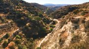
Geological Formations and Soil Composition
The ground beneath the Vasa Kilaniou Trail consists mainly of sedimentary rock and limestone. This composition affects everything from water drainage to the types of plants that grow. The porous nature of the rock allows rainwater to seep into underground aquifers. This process provides a steady supply of water for the village springs. Over time, erosion has carved unique shapes into the hillside.
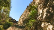
These formations create a dramatic backdrop for the hike. Geologists find this area particularly interesting because it reveals the tectonic history of the island. The uplift of the Troodos range pushed these ancient seabed materials to their current height. This transition from sea to mountain is visible in the fossils sometimes found in the stone.
Seasonal Changes and the Best Time to Hike
Timing is crucial when you plan a visit to the Vasa Kilaniou Trail. Spring is arguably the most beautiful time as the hills turn a vibrant shade of green. The temperature during this period remains cool enough for a comfortable walk. Autumn is another excellent choice because it coincides with the grape harvest.
The smell of fermenting grapes often drifts from the village wineries. Winter brings a different kind of beauty with crisp air and the occasional dusting of snow on the higher peaks. Summer can be very hot, so early morning or late afternoon walks are best during those months. Each season offers a new perspective on the landscape and the local traditions.
Practical Tips for a Successful Walk
A successful trip to the Vasa Kilaniou Trail requires some basic preparation. Sturdy footwear is essential because the limestone tracks can be slippery or uneven. It is important to carry enough water as there are few natural springs directly on the path. A hat and sunscreen protect against the strong Mediterranean sun even on cloudy days.
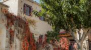
Many people choose to start their walk in the village square. This location offers easy access to local cafes where you can enjoy a traditional Cypriot coffee. Respect for the environment is vital, so visitors should stay on the marked paths. This practice protects the delicate wildflowers and prevents damage to the vineyards.
Connectivity to the Village Life
The trail does not exist in isolation from the village of Vasa Kilaniou. Instead, it serves as a bridge between nature and the community. After a hike, a visit to the local museums provides more context about the region. The Museum of Education and the Viticulture Museum are both located within the village.
These institutions preserve the tools and stories of the people who worked the land. Interacting with the locals offers a chance to learn about the hospitality for which Cyprus is famous. Many residents are happy to share stories about the history of the trail. This human connection makes the physical journey much more meaningful and memorable.


