The Stavrovouni-Lefkara Hills region forms a distinctive landscape in southeastern Cyprus where forested mountain slopes meet traditional agricultural communities. The Stavrovouni Forest has an extent of approximately 19 square kilometres, with its highest peak reaching 688 metres at the center, where the historic monastery stands.
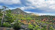
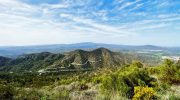
This protected landscape extends from the Stavrovouni Forest in the east through the rolling hills surrounding the villages of Pano and Kato Lefkara. The terrain features pine-covered ridges, rocky outcrops, cultivated terraces, and valleys carved by seasonal streams.
There are over 200 types of plants in the Stavrovouni Forest, 22 of them being endemic. The area serves as an important ecological corridor connecting different habitat types and supporting diverse wildlife populations across varying elevations and microclimates.
- From Ancient Pilgrimage Routes to Conservation Priority
- Diverse Terrain Across Elevation Gradients
- Surprising Facts About Wildlife in the Hills
- Endemic Species That Define This Landscape
- A Working Landscape Where Nature and Culture Meet
- Exploring the Mountain Landscape
- Why This Landscape Deserves Recognition
From Ancient Pilgrimage Routes to Conservation Priority
The Stavrovouni region holds centuries of human history alongside its natural heritage. According to tradition, Stavrovouni Monastery was founded by Saint Helena and Saint Constantine around AD 327-329, establishing this mountain as a sacred site from early Christian times.
The monastery’s presence influenced settlement patterns and land use throughout the surrounding hills for over 1,600 years. Traditional agriculture developed in the lower elevations, with villages like Lefkara becoming renowned for lace-making and silverwork. The forest areas provided timber, charcoal, and grazing land for local communities.
British colonial authorities began formal forest management in the early 20th century, though significant areas were destroyed by repeated fires. Reforestation efforts focused on fast-growing pines, particularly Pinus brutia, which now dominates the landscape. Following independence, the Republic of Cyprus designated portions of the Stavrovouni Forest as protected areas managed by forest departments from Nicosia, Larnaca, and Ammochostos districts. Modern conservation efforts recognize the ecological value of maintaining habitat connectivity between forested mountains and agricultural valleys.
Diverse Terrain Across Elevation Gradients
The landscape exhibits remarkable variety across relatively short distances. The climate in the area is Mediterranean with warm and dry summers from May until mid-October, and mild winters, with average annual rainfall reaching 500 mm.
The Stavrovouni Forest occupies the higher elevations where pine forests provide continuous canopy cover. The dominant species include Calabrian pine, stone pine, olive, carob, and native shrubs such as mastic, turpentine tree, cistus, sage, and thyme. Rocky slopes support specialized plant communities adapted to shallow soils and intense sun exposure.
There are also 12 types of orchids, as well as the plant Euphorbia hierosolymitana, a rare plant included in the Red Book of the Flora of Cyprus.
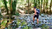
Lower elevations transition to agricultural terraces where traditional crops include grapes, olives, almonds, carobs, figs, pomegranates, and vegetables. The landscape is fragmented by the rivers Syrkatis, Argaki, and St. Minas, all tributaries of the Pentaschoinos river.
These watercourses create riparian corridors that provide moisture-dependent habitats distinct from surrounding dry slopes. The hills around Lefkara feature a mosaic of cultivated land, abandoned terraces reverting to natural vegetation, and wild scrubland that supports diverse wildlife.
Surprising Facts About Wildlife in the Hills
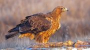
The bird diversity in this landscape reflects its position along major migration routes. Until now, 53 types of birds have been located, 25 of them residents year-round, while 19 are migratory, present during the breeding season from early spring to early autumn.
Important resident species include Bonelli’s Eagle, Long-legged Buzzard, Kestrel, Black-eared Wheatear, and Chukar Partridge. Endemic species such as the Cyprus Warbler and Cyprus Wheatear establish territories in scrubland and forest edges.
The spring migration period brings spectacular numbers of raptors passing through the region. There are 11 types of mammals, with the main species being the fox and the rabbit. The Cyprus fox, an endemic subspecies, hunts throughout the landscape from dense forest to agricultural fields.
There are also 17 types of reptiles, 11 of which are lizards and 6 are snakes. These include endemic species adapted to rocky habitats and Mediterranean scrubland. The stellagama or kourkoutas, a large agamid lizard, commonly basks on stone walls and ruins throughout the region. Cyprus grass snakes inhabit stream corridors and moist areas, while other snake species prefer drier habitats.
Endemic Species That Define This Landscape
Several endemic plants reach significant populations within this protected landscape. The Cyprus golden oak, though more abundant in western mountains, occurs in scattered groves on north-facing slopes where moisture conditions permit.
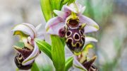
Endemic orchids bloom during spring months, with species adapted to different microhabitats from deep shade to open rocky areas. The rare Euphorbia hierosolymitana grows in small colonies at specific sites, making this one of only two known locations in Cyprus. Among endemic animals, the Cyprus fox represents the island’s only native carnivorous mammal.
This subspecies developed distinctive characteristics during thousands of years of isolation, including smaller size compared to mainland populations and adaptations to Mediterranean climate extremes. The fox plays a crucial ecological role as the apex predator, controlling rodent and rabbit populations.
Endemic reptiles include several lizard species found only in Cyprus. The Cyprus grass snake, a subspecies distinct from mainland populations, survives in permanent streams despite historical population declines from pesticide use. Bird endemics use this landscape extensively, with the Cyprus Warbler particularly abundant in scrubland habitats and the Cyprus Wheatear preferring rocky slopes and cliff faces.
A Working Landscape Where Nature and Culture Meet
The Stavrovouni-Lefkara Hills region demonstrates how conservation can coexist with traditional human activities. Unlike purely wilderness areas, this landscape maintains its ecological value while supporting active villages and agricultural practices.
Traditional land use patterns create habitat diversity, with olive groves, vineyard terraces, and field edges providing resources for many species. Stone walls built centuries ago now serve as refuges for reptiles and small mammals. Abandoned terraces create transitional habitats between cultivated and wild areas, supporting plant and animal species that require intermediate conditions.
The forest areas provide critical services beyond biodiversity conservation, including watershed protection for communities across southeastern Cyprus. Main work in the forest includes fire prevention, maintenance of nature trails, firewall strips, ecosystem management, and wildlife conservation.
Fire management remains a constant concern during dry summer months when vegetation becomes highly flammable. The cultural heritage sites, particularly Stavrovouni Monastery and the traditional villages, attract visitors who contribute to local economies while raising awareness of conservation needs. This combination of natural and cultural values makes the landscape particularly significant for Cyprus as a whole.
Exploring the Mountain Landscape
Visitors can experience this landscape through multiple access points and routes. The main approach follows the road from Larnaca toward Stavrovouni, approximately 17 kilometers northwest of the city. A paved road ascends to the monastery, though women cannot enter the monastery grounds due to longstanding religious restrictions.
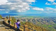
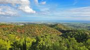
The views from the monastery area extend across the Mesaoria plain to Famagusta in the east, the Troodos Mountains to the northwest, and the Mediterranean Sea to the south. A trail follows the forest road around the periphery of Stavrovouni Hill, running through reforested areas and low scrubby vegetation, covering 7.8 miles.
This route provides opportunities to observe forest ecosystems and wildlife without requiring advanced hiking skills, though the full circuit requires several hours to complete. The villages of Pano Lefkara and Kato Lefkara offer different experiences, with traditional architecture, craft workshops, and restaurants serving local cuisine. Walking from Pigi to Kato Lefkara covers only 1 kilometer, allowing visitors to enjoy extremely green scenery with abundant flowers, particularly in spring.
Almond trees bloom in February, creating spectacular displays across the hillsides. The best seasons for visiting combine comfortable temperatures with peak wildlife activity during spring or autumn months.
Why This Landscape Deserves Recognition
The Stavrovouni-Lefkara Hills region represents an increasingly rare type of Mediterranean landscape where natural and cultural values remain integrated rather than separated. While purely wild areas serve important conservation functions, working landscapes like this demonstrate that biodiversity can thrive alongside human communities when traditional practices respect ecological limits.
The endemic species surviving here depend on the continuation of both forest protection and appropriate agricultural land use. The region provides essential ecosystem services, including water supply, soil conservation, and climate regulation, that benefit communities far beyond its boundaries. The landscape also holds educational value, showing how Cypriots historically managed natural resources sustainably before modern intensive practices.
For visitors, the area offers authentic experiences of traditional village life combined with natural beauty and wildlife observation opportunities. The combination of the ancient monastery, traditional craft villages, and biodiverse mountain forests creates a destination where history, culture, and nature merge. Protecting this landscape ensures that future generations will inherit not just preserved nature or frozen cultural monuments, but a living example of how humans and nature can coexist productively across centuries.