Explore Cyprus with Our Interactive Map

Explore our top stories and discover ideas worth your time.

Modern Naval Heritage

Modern Naval Heritage

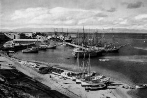
Cyprus has never treated the sea as a boundary. For centuries, its coastline functioned as a working edge where trade, defense, administration, and daily life met. In the modern period, this relationship was shaped most clearly by two naval powers: the Ottoman Empire and the British Empire. Their presence did not simply leave behind forts and harbors. It reshaped how the island was governed, how its ports functioned, and how Cypriots understood their place within the wider Mediterranean world. This article explores how Ottoman and British naval priorities transformed Cyprus from a regional outpost into a strategic maritime asset, and why that legacy still defines the island’s identity today. An Island Positioned to Be Watched Cyprus sits at a crossroads of the eastern Mediterranean, close enough to Anatolia, the Levant, and Egypt to matter to every power operating in the region. This geography made neutrality impossible. Control of Cyprus meant visibility over key sea lanes, access to sheltered anchorages, and influence across multiple trading and military routes. Rather than isolating the island, the sea connected it outward. Cyprus became valuable not for its interior alone, but for how its coastline could support movement, surveillance, and supply. This strategic reality explains why naval priorities repeatedly shaped the island’s administration. What “Modern Naval Heritage” Really Means When discussing naval heritage in Cyprus,…

Read more

Ayios Herakleidios Mosaics

Ayios Herakleidios Mosaics

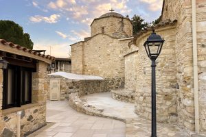
The mosaics at Ayios Herakleidios, in the inland territory of Tamassos, show an early Christian community expressing belief through geometry rather than mythic scenes or imperial display. Laid across successive basilica phases, the floors use repetition, careful placement, and durable materials to create a sense of order during periods of instability. This article explains how the site developed around the saint’s tomb, what the patterns and Chi-Rho symbol were designed to do, and how the mosaics survive alongside a living monastery today. An Inland Sanctuary at Tamassos Unlike Cyprus's major early Christian monuments along the coast, the Ayios Herakleidios complex developed inland, near copper-rich Tamassos, a former city-kingdom once dedicated to pagan gods. The location is essential to understanding the mosaics. This was not an imperial centre drawing wealth and artisans from across the Mediterranean. It was a rural heartland where Christianity spread through local networks, pilgrimage, and the authority of a revered saint. The basilicas rose beside the tomb of Saint Herakleidios, transforming an ordinary burial site into a spiritual anchor for the region. From the beginning, the focus here was not grandeur, but presence. A Tomb That Became a Centre The architectural history of the site unfolds in stages. The earliest Christian structure, a small 4th-century martyrion, was built directly over a Roman tomb believed to hold the…

Read more
Khirokitia UNESCO Chalcolithic Village

Khirokitia UNESCO Chalcolithic Village

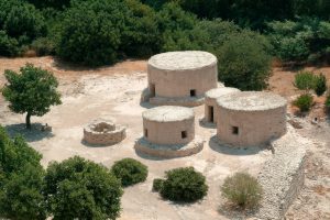
Khirokitia (also spelled Choirokoitia) represents the peak of Cyprus's Aceramic Neolithic period, when communities built permanent settlements without any knowledge of pottery production. The site covers approximately 3 hectares at its maximum extent and consists of circular stone and mudbrick houses clustered together on a hillside. These structures were protected by massive stone walls that enclosed the settlement on multiple sides. The archaeological remains document a sophisticated farming society that thrived for over 1,500 years. Residents cultivated wheat and barley, raised domesticated sheep, goats, and pigs, and supplemented their diet through hunting and gathering wild foods. The settlement's name likely derives from the Greek words for pig (χοίρος) and cradle (κοιτίς), suggesting an area where pigs were raised, though several alternative etymologies exist in local tradition. Historical Background Porphyrios Dikaios, director of the Department of Antiquities of Cyprus, discovered Khirokitia in 1934 during archaeological surveys for the newly established Cyprus Museum. He identified surface scatters of prehistoric material on the terraced slopes of the Maroni River valley. Between 1936 and 1946, Dikaios conducted six excavation campaigns at the site despite interruptions from World War II between 1939 and 1945. His initial findings, published in The Journal of Hellenic Studies in 1934, first dated the settlement to around 4000 BC. However, radiocarbon dating later revealed a much earlier foundation date of…

Read more