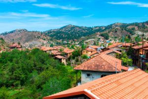
Papoutsa Peak Cyprus Eco Trails
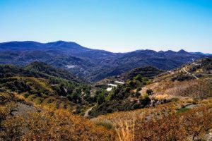
Papoutsa Peak stands at 1,554 metres in the eastern Troodos Mountains, surrounded by one of Cyprus's most important forest reserves. The forests are part of the Adelfoi Forest system, a vast protected area recognized within the Troodos Geopark for its ecological significance. The peak sits between Mount Olympus to the west and Madari to the north, creating a corridor of protected wilderness that covers over 120 square kilometres. Unlike more accessible Troodos peaks with developed facilities, Papoutsa maintains a wilder character with fewer visitors and more pristine ecosystems. The mountain lies within the Papoutsa and Adelfoi Forests mentioned by the Troodos Geopark as among the island's most noteworthy woodland areas. These forests protect crucial habitat for species found nowhere else on Earth. The combination of elevation, geology, and minimal human disturbance creates conditions where rare plants and animals can survive pressures that threaten them in more accessible locations. Historical Background The Troodos Mountains, including Papoutsa, emerged approximately 92 million years ago as oceanic crust from the ancient Tethys Ocean. Tectonic forces pushed this underwater rock upward through obduction, eventually creating the island's central mountain mass. Papoutsa consists of the same serpentinized harzburgite and peridotite rocks found throughout Troodos, representing mantle material from thousands of metres beneath the ancient seabed. These ultramafic rocks create unique soil chemistry with high concentrations of…
Read more