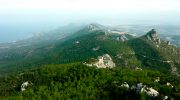
Cyprus villages evolved through intimate relationship between human settlement and natural terrain, creating communities shaped by mountains, valleys, water sources, and agricultural land. The island’s dramatic geography, dominated by the Troodos Mountains rising to 1,952 meters and the northern Kyrenia Range reaching 1,024 meters, determined where people built homes and how they organized village life.

Between these ranges lies the Mesaoria Plain, Cyprus’s agricultural heartland where lowland villages spread across fertile flatlands. Mountain villages cling to steep slopes, terraced into hillsides at multiple elevations with buildings accessible from streets at different heights.
This landscape adaptation created sustainable settlement patterns that persisted for millennia, balancing human needs with environmental constraints while maintaining agricultural productivity. The terracing, water management, and compact building forms demonstrate sophisticated understanding of terrain that allowed dense population while preserving productive farmland surrounding villages.
Geography Determines Settlement Patterns
Cyprus’s two mountain ranges and central plain created distinct regional settlement types. Troodos foothill villages occupy elevations between 400 and 1,200 meters where mineral-rich volcanic soils support vineyards, fruit orchards, and olive groves. These villages developed around copper mining from the Bronze Age through the 20th century, combining agriculture with metallurgical industries that connected Cyprus to Mediterranean trade networks. Villages like Politiko-Troullia in the Troodos foothills prospered from copper resources less than one kilometer away while maintaining agricultural terraces on adjacent hillsides.
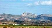
The Kyrenia Range villages face north toward Turkey, with steep slopes descending to narrow coastal plains. These settlements developed defensive characteristics due to proximity to sea-borne raiders and invaders. Medieval castles crown prominent peaks including Saint Hilarion and Buffavento, with villages clustering below for protection. The limestone geology of the Kyrenia Range provided excellent building stone but limited water sources compared to the volcanic Troodos region.
Mesaoria Plain villages spread horizontally across flatlands where deep alluvial soils support grain cultivation, vegetables, and citrus orchards. These lowland settlements lack the dramatic hillside terracing of mountain villages but developed different adaptations including extensive underground water cisterns, windbreaks of cypress trees, and fortified compounds protecting against raiders crossing open terrain. The plain’s strategic importance for agriculture made it contested territory throughout Cyprus history.
Water Sources Shape Village Locations
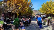
Access to permanent water determined settlement viability in Cyprus’s semi-arid climate where rainfall concentrates in winter months. Mountain villages located near springs that provided year-round flow, with communities organizing around these precious resources. The village fountain or vrisi became the social center where women gathered to draw water, wash clothes, and exchange information. These fountains featured stone basins, decorative spouts, and shaded sitting areas that transformed utilitarian infrastructure into community gathering spaces.

Streams flowing from Troodos mountains supported villages along their courses, with water rights systems allocating flow to families for irrigation in rotation. The complex water sharing arrangements required sophisticated social organization and dispute resolution mechanisms that reinforced community cohesion. Violations of water rights could trigger blood feuds lasting generations, demonstrating these resources’ critical importance.
Villages without surface water developed elaborate cistern systems collecting winter rainfall from roofs and courtyards into underground chambers carved from bedrock or built with waterproof plaster. These cisterns, some holding thousands of liters, allowed settlement in areas otherwise too dry for permanent habitation. The technology required substantial communal labor for excavation and maintenance, creating interdependence that strengthened village social bonds.
Agricultural Terracing Preserves Farmland
Mountain villages created extensive terracing systems that transformed steep hillsides into productive agricultural land while preventing erosion. These stone walls, built without mortar from locally quarried limestone, follow contour lines to create level planting surfaces. Archaeological surveys at Politiko-Koloiokremmos documented 102 terrace walls across approximately 20 hectares, representing centuries of accumulated agricultural engineering.
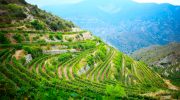
The terraces served multiple functions beyond crop production. They slowed water runoff during intense winter storms, allowing gradual soil absorption that recharged aquifers and prevented devastating floods. The stone walls created microclimates warmer than surrounding areas, extending growing seasons for temperature-sensitive crops. The structures also defined property boundaries and demonstrated family investment in land improvement that increased property value across generations.
Terrace construction and maintenance required substantial labor inputs. Families worked collectively to build walls, repair storm damage, and clear accumulated sediment. This cooperative effort created reciprocal obligations where wealthy landowners provided leadership and resources while poorer families contributed physical labor. The terraces thus embedded social hierarchies into the landscape while creating common interests in maintaining agricultural infrastructure.
Compact Villages Preserve Agricultural Efficiency
Cyprus villages developed compact clustered forms that minimized land consumption while maximizing arable acreage surrounding settlements. Houses pressed close together along narrow streets, with courtyards providing private outdoor space within high stone walls. This dense configuration meant villages occupied minimal footprints despite substantial populations, leaving surrounding hillsides and valleys available for cultivation.

The clustering served defensive purposes when bandits and raiders threatened isolated farmsteads. Village density allowed rapid mobilization of male population for collective defense, with narrow streets impeding cavalry and creating defensive bottlenecks. The proximity also facilitated social monitoring where community observation discouraged antisocial behavior and enforced cultural norms through informal sanctions.
Modern agricultural mechanization challenges traditional compact forms. Tractors and harvesters require wider access routes than donkey paths provided, prompting road expansion that consumes agricultural land. Some villages have experienced sprawl as younger generations build larger homes with parking areas on village peripheries, breaking historical patterns of density and land conservation.
Building Materials From Local Geology
Village architecture reflects local geological conditions, with buildings constructed from stone quarried nearby. Troodos villages use dark volcanic diabase and lighter limestone depending on proximity to different rock formations. The volcanic stone’s hardness provides excellent structural strength but requires more effort to shape. Kyrenia Range villages rely entirely on limestone, creating settlements of uniform pale stone that reflects intense sunlight.

The local sourcing minimized transportation costs while creating distinctive regional architectural character. Visitors can identify a village’s geographical location by observing building stone color and texture. This hyperlocal material use also meant villages possessed expertise in working specific stone types, with masonry techniques adapted to particular rock properties and structural capabilities.
Timber use depended on forest access, with Troodos mountain villages incorporating more wooden structural elements including ceiling beams, roof supports, and balconies. Lowland villages lacking timber sources developed vaulted stone roofing that eliminated wood requirements while creating distinctive architectural forms. The material constraints thus shaped building technology and aesthetic expression across different regions.
Contemporary Challenges to Balance
Traditional village landscapes face pressure from rural depopulation as younger generations migrate to urban employment. Abandoned terraces collapse without maintenance, allowing erosion that destroys centuries of agricultural engineering. Unmaintained stone buildings deteriorate, with roofs collapsing and walls crumbling. The knowledge required for proper stone masonry and terrace maintenance diminishes as fewer people practice traditional construction techniques.
Tourism provides economic justification for landscape preservation while creating new tensions. Some villages restore traditional architecture for boutique accommodations and cultural tourism, generating income that supports rural economies. However, this commercial preservation risks creating museum-like environments disconnected from authentic agricultural life that originally shaped village forms.
Government programs offer restoration grants for traditional buildings and terraces, requiring property owners to maintain historic character while permitting interior modernization. These initiatives aim to prevent complete abandonment while acknowledging that contemporary living standards require modifications to structures designed for preindustrial lifestyles. The balance between preservation and adaptation remains contested as communities negotiate between heritage conservation and practical needs.