Cyprus experiences a subtropical Mediterranean climate characterized by hot, dry summers from mid-May to mid-September and rainy, changeable winters from November to mid-March separated by short autumn and spring seasons. The island enjoys between 300 and 340 sunny days annually, making it one of the sunniest places in Europe.
However, 2026 continues a troubling pattern of climate variability and extremes that have marked recent years. Variability in annual rainfall is characteristic for the island, and droughts are frequent and sometimes severe. Understanding these patterns becomes crucial for agriculture, water management, and planning across all sectors of Cypriot life.
Temperature Patterns Across the Island
Cyprus is a region with a hot climate. The day temperatures range from 16 degrees Celsius in January to 34 degrees Celsius in August. Temperatures during the night go from 7 degrees Celsius in February to 22 degrees Celsius in August. These averages mask significant regional variation driven by topography and distance from the coast.
Variations in temperature and rainfall are governed by altitude and, to a lesser extent, distance from the coast. Coastal areas maintain more moderate temperatures year-round, with average January temperatures around 12 degrees Celsius. The sea itself ranges from 16 degrees Celsius in February to 27 degrees Celsius in August, extending the practical swimming season from May through October

The inland plain where Nicosia sits experiences Cyprus’s most extreme temperatures. The capital is locked between two mountain ranges that block moderating sea breezes, creating a heat island effect. During summer, Nicosia regularly exceeds 40 degrees Celsius during heat waves originating from Africa. In 2020, temperatures reached 43 degrees Celsius in mid-May and 45 degrees Celsius in early September, demonstrating the increasing frequency of extreme heat events.

The Troodos Mountains provide the island’s coolest refuge, with temperatures dropping significantly at higher elevations. Winter temperatures in the mountains fall to minus 5 degrees Celsius at night, allowing snow accumulation that supports ski resorts from January through March. The highest peaks can receive 2 to 2.5 meters of snow during good winters, though snow coverage varies considerably year to year.
Rainfall Distribution and Seasonal Patterns
Cyprus receives limited annual rainfall concentrated in winter months. The least rainfall occurs in the Mesaoria, with 300 to 400 millimeters a year. Coastal cities like Larnaca and Limassol average 350 to 400 millimeters annually, while precipitation increases from 450 millimeters up the south-western windward slopes to nearly 1,100 millimeters at the top of the Troodos massif.

The narrow ridge of the Kyrenia range, stretching 160 kilometers from west to east along the extreme north of the island produces a relatively small increase in rainfall of around 550 millimeters along its ridge at an elevation of 1,000 meters. The Karpas Peninsula in the northeast remains one of the driest regions, averaging 400 to 450 millimeters annually.
Winter precipitation from December through February accounts for approximately 60 percent of annual totals. The driest month is July with just 0 days of rain, on the contrary, the month when it rains the most is January with 10 days of rain. Summer months from June through September see virtually no rainfall, creating severe water stress for agriculture and natural ecosystems.
Drought Cycles and Water Security
The eastern half of Cyprus proves particularly vulnerable to drought. Winter rains can be so unreliable that some years near-drought conditions prevail, threatening agriculture and water supplies. The combination of low rainfall, high evaporation rates during hot summers, and increasing demand from population growth and tourism strains water resources.
High temperatures combined with low rainfall can exacerbate drought, while intense rainfall following dry periods can increase flood risk due to reduced soil absorption. This creates a dual challenge where Cyprus faces both water scarcity and occasional flash flooding when intense rains fall on parched, compacted soil unable to absorb moisture quickly.
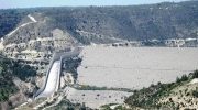
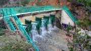
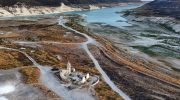
Cyprus has constructed major dams and water distribution systems to capture winter rainfall for summer use. The Conveyor Project, completed in 1993, collects surplus water from the southwestern part of the island and conveys it via a 110-kilometer water carrier to central and eastern areas. However, even this infrastructure proves insufficient during extended drought periods.
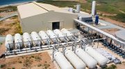
Desalination plants now supplement natural water sources, producing drinking water from seawater at significant energy cost. These facilities have become essential infrastructure as climate patterns shift toward more frequent and severe droughts.
Climate Change Projections for Cyprus
Temperature trends show clear warming signals particularly from the late 20th century onward. Climate models project continued warming under all emissions scenarios, with the magnitude depending on global greenhouse gas trajectories. Maximum daytime temperatures prove particularly important for assessing heat stress, wildfire risk, and drought conditions.
Heat stress concerns grow especially relevant in urban areas where the heat island effect intensifies impacts. Nicosia, already experiencing extreme summer temperatures, faces additional warming that could push summer conditions beyond human comfort thresholds for outdoor work and activities.
Precipitation trends prove more complex and regionally variable than temperature patterns. Models show inconsistent projections for future rainfall, with some suggesting slight decreases and others maintaining current patterns. This uncertainty complicates long-term water planning. What appears consistent across projections is increased variability, meaning both severe droughts and intense rainfall events may become more common.
The shift from stable Mediterranean climate toward semi-arid conditions concerns climatologists. Areas classified as Csa, or hot-summer Mediterranean climate, may transition toward BSh, or hot semi-arid climate, as rainfall decreases and temperatures rise. This classification change would have profound implications for agriculture, water management, and ecosystem health.
Adapting to New Climate Realities
Cyprus must adapt agricultural practices to changing conditions. Traditional crops suited to reliable winter rains and moderate summers face increasing stress. Farmers increasingly adopt drought-resistant varieties, install drip irrigation systems that minimize water waste, and shift planting schedules to avoid extreme heat periods.
Water conservation has become a national priority. Public campaigns encourage reduced household water use, while regulations limit garden watering and car washing during summer. Greywater recycling systems are being installed in new developments, and rainwater harvesting gains popularity despite limited rainfall.

Urban planning increasingly incorporates climate adaptation measures. Green spaces and tree planting combat heat island effects in cities. Building codes now emphasize insulation and passive cooling to reduce energy demands during extreme heat. White or reflective roof surfaces help buildings stay cooler.
The tourism industry faces challenges from extreme summer heat that may make peak season uncomfortably hot for visitors. The sector is beginning to promote shoulder seasons in spring and autumn when temperatures remain pleasant but crowds are smaller. Some resorts invest in additional cooling and shading infrastructure.