The Anerades Nature Trail serves as a significant ecological asset within the Paphos district of Cyprus. This path winds through the valley of Milliou which is a region famous for its abundant water sources and citrus orchards. Visitors walk through a landscape that stays green even during the hot summer months.
The trail provides a direct link to the rural traditions and folklore of the island. Local myths suggest that fairies once lived in the nearby caves and springs of the area. This cultural element adds a unique layer to the physical journey through the river valley.
Modern travelers use this route to observe the diverse plant life of the Mediterranean interior. It offers a cool retreat from the coastal heat and a chance to study local geology. The environment supports a wide variety of birds and small mammals that thrive in the dense vegetation.
- Trail Overview
- Geographical Context of the Milliou Valley
- Botanical Diversity and the Citrus Industry
- Historical Sites and Religious Monuments
- Avian Populations and Wildlife Habitats
- Springs Across The Trail
- Agricultural Traditions and Land Use
- Geological Formations and Soil Profiles
- Best Time to Hike
- Practical Advice for Trail Visitors
Trail Overview
- Location: Milliou Village, Paphos District, Cyprus
- Distance: 1.2 miles (2 km)
- Route Type: Circular Loop
- Difficulty: Easy
- Elevation Gain: 40 meters
- Duration: 45 – 60 minutes
- Best Time to Visit: March – May and September – November
- Terrain: Dirt tracks and riverbed paths
Geographical Context of the Milliou Valley
Milliou sits at a low altitude within the hilly terrain of the western Paphos region. This village is one of the smallest on the island but it possesses a high concentration of natural springs. The Anerades Nature Trail benefits from this constant supply of water which feeds the local flora throughout the year.
The soil in this area is rich and fertile due to the sediment from the nearby mountains. This geological setup creates a microclimate that differs from the arid plains of the south. The path remains relatively flat as it follows the contours of the valley floor. This makes the walk accessible to people of all ages and fitness levels.
Botanical Diversity and the Citrus Industry
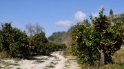
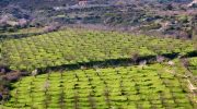
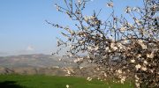
The plant life along the Anerades Nature Trail is both wild and cultivated. Orange and lemon trees dominate the agricultural parts of the route. These trees bloom in late winter and fill the air with a sweet scent. In the wilder sections you will see plane trees and alder trees that cluster near the water.

These large trees provide ample shade which helps to keep the trail cool. Oleander bushes add splashes of pink and white color during the late spring months. The variety of herbs like mint and lemon balm grow near the stream banks. These plants have served medicinal purposes for the local population for many centuries.
Historical Sites and Religious Monuments
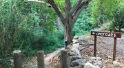
History is a constant presence along the Anerades Nature Trail. The path passes near the Monastery of Agioi Anargyroi which dates back to the seventeenth century. This site is famous for its sulfur springs that people used for therapeutic baths. Many travelers visited this location to seek relief from various physical ailments.
The old stone architecture of the monastery remains a focal point of the valley. Small chapels also dot the landscape and offer a place for quiet reflection. These buildings reflect the religious devotion of the people who worked this land. The masonry work on these structures shows the skill of ancient local craftsmen.
Avian Populations and Wildlife Habitats
The dense vegetation of the valley creates a perfect habitat for numerous bird species. Birdwatchers often frequent the Anerades Nature Trail to spot the Cyprus warbler. This small bird is endemic to the island and finds shelter in the thick shrubs. The sound of water attracts larger birds like the grey heron and the kingfisher.
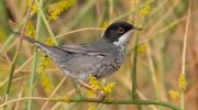
In the early morning hours you might hear the call of the scops owl. Small reptiles like the Cyprus lizard bask on the rocks near the path. The presence of these animals indicates a healthy and balanced ecosystem. The trail serves as a protected corridor where wildlife can thrive without disturbance.
Springs Across The Trail
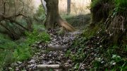
The water system of the Milliou valley is the lifeblood of the entire region. The springs that feed the Anerades Nature Trail originate from deep underground aquifers. This water is rich in minerals which contributes to the health of the local crops. Historically the villagers used these springs for irrigation and for their own daily needs.
The constant flow of water prevents the soil from becoming too dry during the summer. This hydrology supports a unique set of aquatic plants that do not grow elsewhere on the island. The sound of the stream is a constant companion for those who hike this route. This element of the trail makes it a sensory experience as much as a physical one.
Agricultural Traditions and Land Use
Agriculture remains the primary economic activity for the people who live near the trail. The terraces that line the valley walls show the effort required to farm this rugged land. Besides citrus fruits the area produces grapes and walnuts in large quantities. The Anerades Nature Trail offers a direct view into these working farms.
It is common to see local farmers as they tend to their trees or harvest their fruit. This interaction highlights the relationship between the people and the land. The traditional methods of farming have changed very little over the past few decades. This continuity ensures that the landscape retains its authentic rural character.
Geological Formations and Soil Profiles
The ground beneath the Anerades Nature Trail consists mainly of sedimentary rock and clay. This composition is ideal for the retention of water which benefits the local trees. Over time the river has carved a shallow path through the valley floor. This erosion reveals the layers of the earth and the history of the water flow.
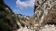
Some parts of the trail feature limestone outcrops that contrast with the dark soil. These rocks provide a stable foundation for the path and prevent excessive erosion. The mineral content of the soil gives the land a dark and fertile appearance. This geology is the reason why the Milliou valley is so productive compared to other regions.
Best Time to Hike
The appearance of the Anerades Nature Trail changes significantly with the seasons. Spring is the most vibrant time as the citrus trees and wildflowers bloom. The weather during this period is mild and perfect for a long walk. Autumn brings a different beauty as the leaves of the plane trees turn to gold.
The harvest season also starts at this time which means the village is very active. Winter is often wet but the valley stays green and the springs flow with more force. Summer is hot but the shade from the trees makes the trail manageable. Each time of year offers a new perspective on the natural cycle of the valley.
Practical Advice for Trail Visitors
A visit to the Anerades Nature Trail is easy to plan with a few basic tips. The path is well marked but it is always good to have a local map. Since the terrain is mostly flat you do not need heavy hiking boots. A pair of comfortable walking shoes with good grip is sufficient for the dirt tracks.
It is wise to carry a bottle of water even though the walk is short. Sunscreen and a hat are essential because the Mediterranean sun is strong. The trail starts near the Agioi Anargyroi hotel where you can find parking. Respect for the environment is important so please do not pick the flowers or disturb the animals.


