
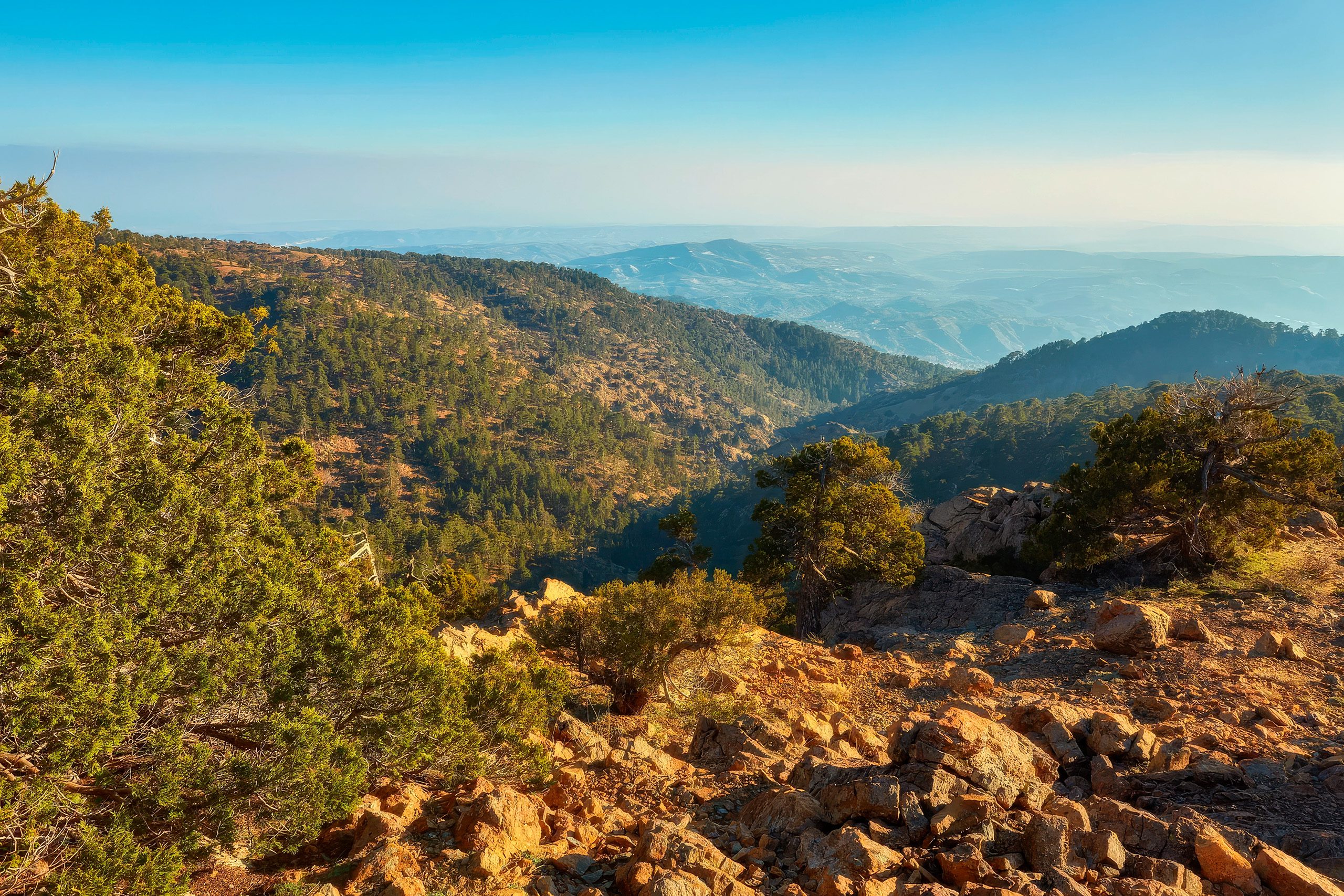
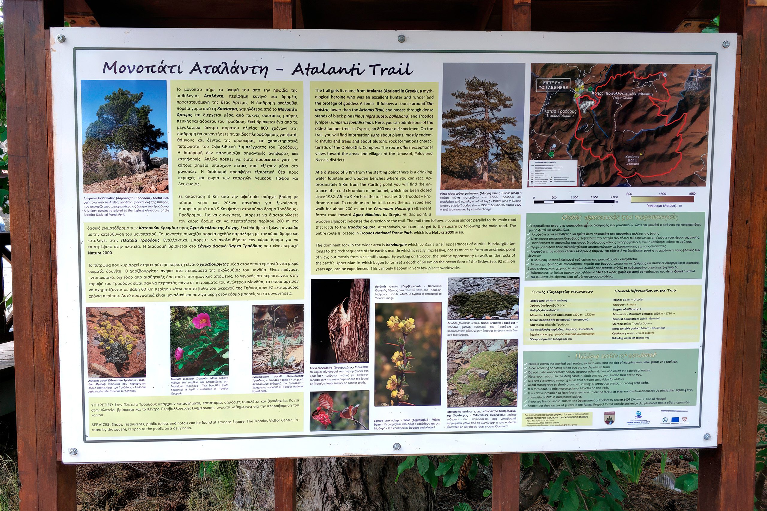
The Atalanti Nature Trail wraps around Mount Olympus at an altitude where black pines grow thick, and views stretch across the entire island of Cyprus. This 14-kilometer circular route offers a longer alternative to the more popular Artemis Trail, with the same mountain setting but fewer crowds. The path combines ecological education with genuine wilderness experience, complete with an abandoned chromite mine and an 800-year-old juniper tree.
The Atalanti Nature Trail sits at 1,700 to 1,750 meters above sea level in the Troodos National Forest Park. The route starts and ends at Troodos Square, the main gathering point in the Troodos Mountains. Despite its 14-kilometer length, the trail maintains a relatively flat profile throughout most of its course, with only the final quarter showing noticeable elevation changes.
The trail is officially designated as a geo-trail, which means it includes geological interpretation along with natural history. Walking time ranges from 3 to 5 hours, depending on pace and how often hikers stop to examine the landscape.
Historical Background
Atalanti takes her name from Atalanta, one of the few female heroes in Greek mythology who appears as a central figure. According to myth, her father abandoned her as an infant because he wanted a son. A she-bear found and nursed the child until hunters discovered her and raised her.
She grew up to become a skilled huntress and devoted follower of the goddess Artemis. Atalanta achieved fame when a monstrous boar ravaged the kingdom of Calydon. She joined the hunt and became the first to draw blood from the beast. The trail name honors this connection to wilderness, hunting, and the goddess Artemis, whose companion trail sits higher on the same mountain.
The Hadjipavlou chromite mine sits directly along the trail route, its entrance tunnel visible to all who pass.
This mine operated from 1950 to 1954, making it the smallest of three chromite mines around Mount Olympus. Miners used underground exploitation methods to extract high-grade chromite ore. During its brief operational period, the mine produced approximately 1,500 tons of chromite ore. The mine entrance remains accessible to view, though the tunnel itself has partially collapsed and is not safe to enter.
Chromite mining in Cyprus began in 1922 with small surface excavations. The three mines around Mount Olympus collectively extracted approximately 1,200,000 tons of ore, yielding more than 605,000 tons of chromite concentrate after processing. Operations ended in 1982 due to falling chromite prices and competition from cheaper South African sources. The unique geology of Troodos created these deposits when oceanic crust was pushed up from the seafloor millions of years ago.
The trail intersects with the Artemis Trail at two points, allowing hikers to combine or switch between routes. Particularly ambitious hikers can walk both trails in a single day, though this covers more than 20 kilometers.
The Atalanti Trail takes roughly twice as long as Artemis but rewards hikers with greater wilderness due to lower foot traffic.
What Sets This Trail Apart
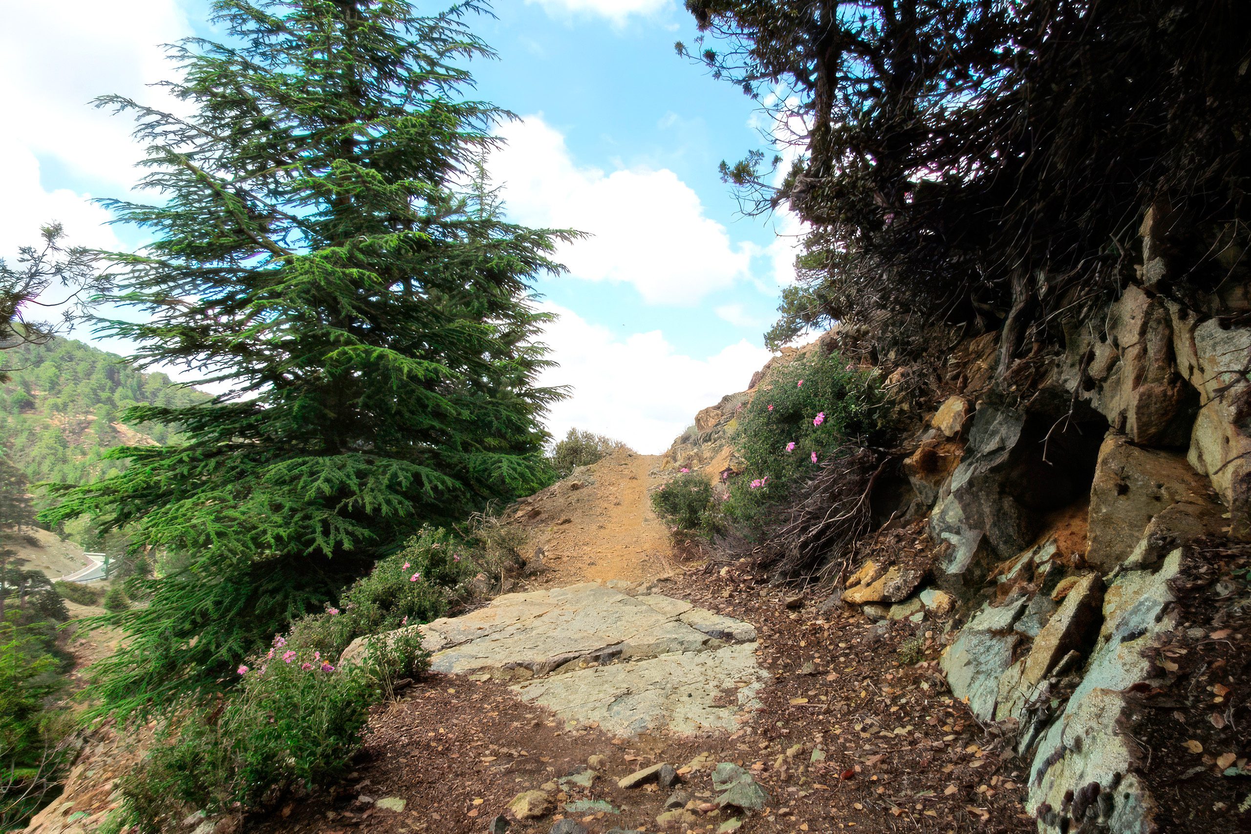
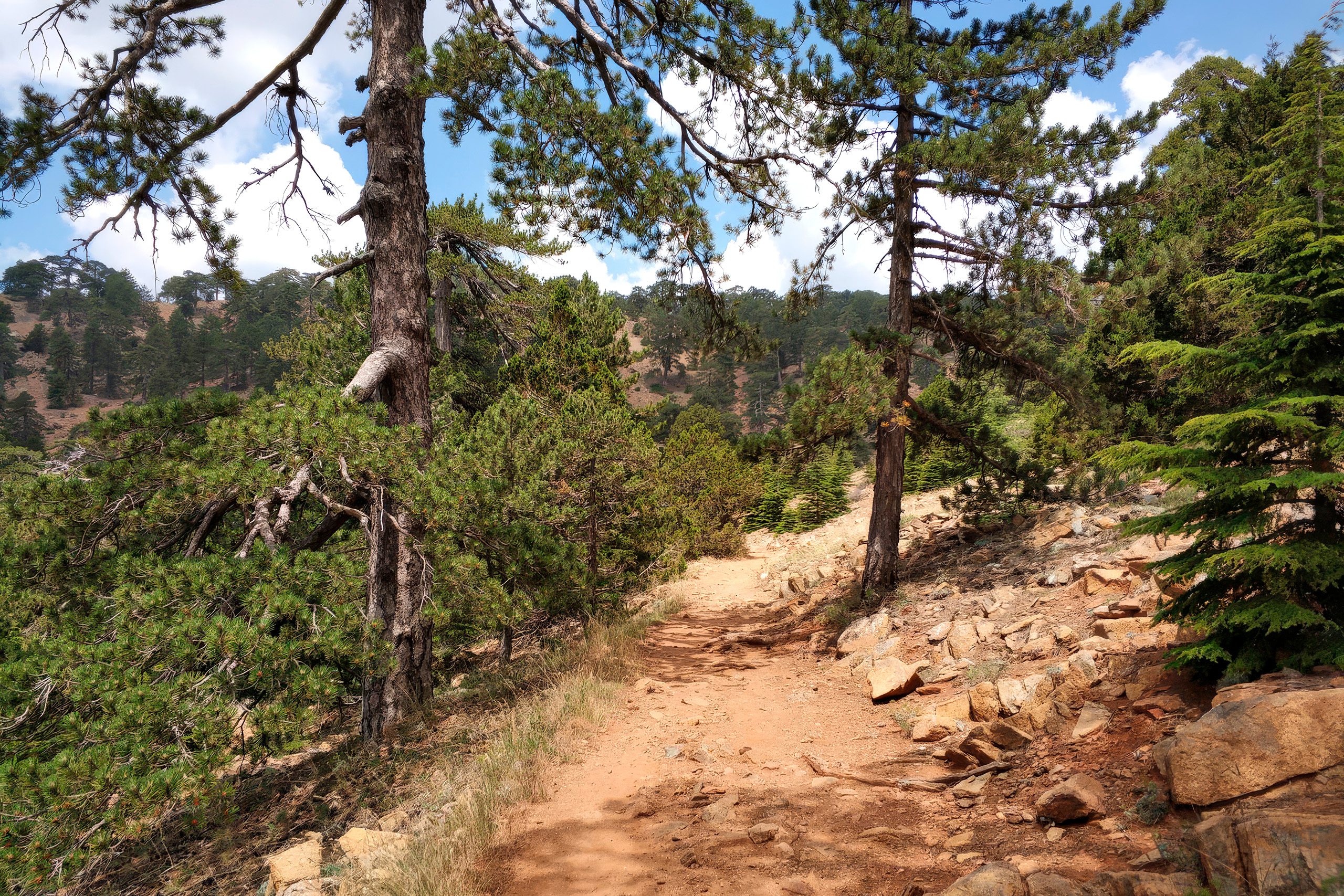
The defining characteristic of the Atalanti Trail is its passage through dense black pine forest at high altitude. The trees, Pinus nigra subspecies pallasiana, create shade for most of the route. The forest opens periodically to reveal panoramic views across the island. On clear days, hikers can see the northern coast, southern coast, and everything between.
Troodos juniper trees grow alongside the pines. These trees, scientifically known as Juniperus foetidissima, are locally called the invisible trees. One specimen along the trail has reached approximately 800 years old, making it one of the largest junipers on the island. The age of this tree means it was already centuries old when the Venetians ruled Cyprus.
The trail follows clear markers throughout its length, with signage at kilometer intervals. The path surface varies from forest floor covered in pine needles to rocky sections. Trail maintenance is notably good, with hikers frequently commenting that this is one of the best-marked routes in Cyprus.
Benches appear at viewpoints where hikers can rest. At the 3-kilometer mark, a natural spring provides fresh drinking water that hikers consistently describe as excellent.
Educational Features Along the Route
The Forestry Department has placed small informational tags throughout the trail identifying various plant species and geological features. These tags provide scientific names and brief descriptions, turning the walk into an educational experience for those interested in learning about the ecosystem.
Plant species labeled along the route include Troodos sage, catmint, germander, alyssum, and several juniper varieties. Cyprus skullcap, an endemic species found nowhere else on Earth, grows in certain sections.
The geological information proves particularly interesting given the unique origin of the Troodos Mountains. The trail passes through rocks that would normally sit several kilometers beneath the ocean floor, including harzburgite, dunite, and chromite-bearing rocks. The exposed ophiolite sequence represents oceanic crust and upper mantle that rose from the seafloor during Mediterranean formation. Geologists consider the Troodos ophiolite one of the most complete examples in the world.
Bird species inhabit the forest, with coal tits appearing regularly. The protected forest environment supports various small mammals, though they typically avoid the trail when hikers are present. The combination of altitude, forest cover, and NATURA 2000 protection has allowed wildlife populations to maintain themselves despite trail popularity.
A Less Crowded Mountain Experience
The Atalanti Trail serves hikers who want a longer mountain experience without extreme difficulty. Its 14-kilometer length discourages casual visitors who prefer shorter walks, which means the trail remains relatively uncrowded even during peak tourist season.
Hikers frequently report encountering only a handful of other people during their entire walk. This relative solitude provides a different experience from the busier Artemis Trail, where groups are more common.
The trail demonstrates ongoing efforts to balance public access with environmental protection. Regulations prohibit smoking throughout the route due to fire danger. Visitors must stay on marked paths to protect rare plant species. The absence of trash bins along the trail means hikers must carry out everything they bring in.
These rules reflect a conservation approach that trusts visitors to behave responsibly rather than installing extensive infrastructure.
For Cyprus residents, the Troodos trails provide an escape from summer heat and coastal development. The temperature difference between the coast and this altitude can reach 15 degrees Celsius. This cooling effect makes the trail particularly popular from June through September.
The trail also serves educational purposes, introducing visitors and locals to the unique geology and ecology of the Troodos range.
Getting There and What to Expect
The trailhead sits at Troodos Square, just behind the old post office building on the northwest side of the square. A wooden shelter marks the starting point.

Free parking is available at the square, which includes several shops, restaurants, and public toilets. An information kiosk provides maps and current trail conditions.
From Limassol, the drive takes approximately one hour. From Nicosia, the journey requires about 90 minutes on well-maintained mountain roads.
Public bus service connects both cities to Troodos. Bus 64 from Limassol arrives at approximately 11:00 and departs for the return journey at 16:00, which provides just enough time to complete the trail at a brisk pace. Most hikers prefer private vehicles to avoid rushing.
The trail is accessible year-round, though winter conditions from January to March can include snow cover that changes the character of the walk significantly. Some sections become slippery when wet or icy.
One section requires crossing the Prodromos-Troodos road after about 9 kilometers. Signs direct hikers to walk along the forest road toward Agios Nikolaos tis Stegis church for roughly 200 meters before markers point back to the trail. This road crossing represents the only potentially confusing section.
The final 4 kilometers after the crossing include more elevation change than earlier sections.
The Atalanti Nature Trail offers what many hikers value most: genuine quiet, substantial distance without excessive difficulty, and a landscape that feels wild rather than managed.
The combination of ancient trees, geological curiosities, industrial ruins, and expansive views creates an experience beyond simple exercise. The trail proves that Cyprus contains more than beaches and archaeological sites, providing access to a high-altitude environment where the ocean floor now sits nearly 2,000 meters above the sea.
For those willing to spend four or five hours in a pine forest and past geological wonders, the trail delivers a different perspective on what this island offers.


