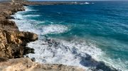
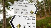
The Kionia to Profitis Elias Nature Trail represents a significant route within the Machairas forest network. This path connects the high peak of Kionia with the historic chapel of Profitis Elias. It offers a clear view of the eastern Troodos mountain range and the surrounding valleys.
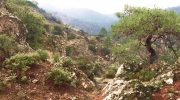
Visitors witness a landscape that transitions from dense pine thickets to open rocky ridges. The air at this altitude stays remarkably fresh and carries the scent of wild mountain herbs. This specific environment supports a variety of plants that flourish in the volcanic soil of the region.
Each section of the track provides a new perspective on the natural history of the island. The path follows the ancient contours of the land to ensure a steady and rhythmic pace. It serves as an ideal destination for those who seek a quiet encounter with the wild peaks.
Trail Overview
- Location: Machairas Forest, Nicosia District
- Distance: 4.3 miles (7 km)
- Route Type: Linear
- Difficulty: Moderate
- Elevation Gain: 980 feet (300 meters)
- Duration: 3 – 3.5 hours
- Best Time to Visit: February – May
- Terrain: Rocky and Dirt Path
Botanical Composition and Forest Ecosystem
The Kionia to Profitis Elias Nature Trail sits within a vast expanse of Calabrian pine forest. These trees dominate the northern slopes and provide a consistent canopy for the traveler. This shade is vital for the survival of smaller shrubs like the golden oak. This oak species is endemic to the island and features leaves with a yellow tint on the underside. The presence of these trees creates a stable habitat for many different forms of life. The soil beneath the pines stays cool and holds moisture even during the dry months.
Wildflowers appear in massive numbers along the edges of the path during the spring season. The Cyprus orchid and several types of rock rose bloom in quick succession. These plants rely on the minerals that the volcanic rock provides to the earth. The forest also hosts a large population of wild sage and thyme. These herbs add a distinct aroma to the mountain breeze as the sun warms the hillside. The biodiversity of the Machairas region makes it a primary site for botanical research and nature study. Every mile on the track offers a new fact about the resilience of the local flora.
Geological Structure and Volcanic Formations
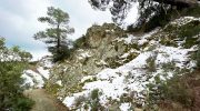
The geology of the Kionia area is a subject of great interest for scientists around the world. This trail moves over rock layers that formed on the ocean floor millions of years ago. The terrain consists mainly of diabase and pillow lavas that rose during tectonic shifts. These stones have a dark color and a very dense structure that resists the power of weather. The soil is quite thin which forces the tree roots to wrap around the rocks for stability.
The path follows a ridgeline that offers a cross section of the volcanic history of the island. Hikers see exposed cliffs where the different layers of the earth are visible to the eye. These formations tell a story of the intense heat and pressure that shaped the mountains. Rainwater and snowmelt collect in small channels and feed the streams in the lower valleys. This water cycle is essential for the health of the entire forest ecosystem.
Avian Life and Mountain Wildlife Observations
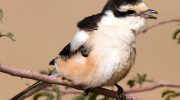
Birds are the most common animals that people see along the Kionia to Profitis Elias path. The endemic Cyprus wheatear often sits on the rocky outcrops to watch for small insects. This bird prefers the high elevations and the open spaces near the mountain peaks. The coal tit and the masked shrike also move through the pine branches in search of food. Their calls are often the only sound that breaks the silence of the forest during the day. These species play a key role in the natural balance of the mountain environment.
Larger animals inhabit the denser parts of the woods far away from the main track. The Cyprus mouflon is the most iconic resident although it is very shy and avoids humans. This wild sheep has a thick coat and strong horns that help it navigate the steep rocks. Tracks of the red fox frequently appear in the dust after a light rain in the morning. These predators help to control the population of rodents within the forest boundaries. The lack of human development allows these animals to live in a state of total freedom. The trail provides a rare window into a world that remains wild and untouched.
Historical Heritage and Local Landmarks
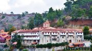
The trail begins near the Kionia picnic site which has served as a rest stop for decades. This area was a base for foresters who managed the timber resources of the Machairas range. The path to Profitis Elias follows old routes that shepherds and monks used in the past. These people understood the rhythms of the mountain and respected the power of the weather. The small chapel of Profitis Elias stands at the end of the route as a silent monument. It represents the deep spiritual link between the local people and the high places.

Stone ruins and old terraces are visible in certain sections of the valley below the trail. These structures show how the people of the mountains used every bit of land for survival. The monastery of Machairas is also a short distance away and holds great cultural value. Many visitors combine a hike on the trail with a visit to this historic religious site. The forest acts as a buffer that protects these landmarks from the noise of modern life. This historical context makes the walk feel like a journey through the memory of the island. Forestry experts now use the path to educate the public about the importance of cultural conservation.
Path Conditions and Navigation Protocol
The surface of the Kionia to Profitis Elias Nature Trail is a mix of hard earth and loose gravel. This requires a decent level of physical fitness and the use of boots with a firm grip. The path is well marked with signs that provide directions and distances at major turns. Some sections are quite narrow as they move along the edge of the steep ridges. These areas offer the most spectacular views of the Mesaoria plain and the northern coast. The steady elevation gain provides a good challenge for those who enjoy a brisk walk.
Maintenance teams clear the path after the winter storms to ensure that it stays safe for the public. It is important to stay on the marked track to protect the rare mountain flowers. The sun can be very intense on the open parts of the ridge so a hat is a basic need. There are no water taps along the linear route so every hiker must carry a full supply. This preparation ensures that the focus remains on the beauty and the facts of the land. The trail design respects the natural flow of the mountain side and avoids any damage to the soil.
Seasonal Variations and Climate Dynamics
Spring is the best time to experience the life and color of the Kionia trail. The ground is moist and the air is full of the sound of active birds and insects. Summer offers a cool refuge when the heat on the coast becomes too difficult to bear. The temperature at this altitude stays several degrees lower than the city of Nicosia. Autumn brings a subtle change as the golden oak leaves turn to shades of amber and gold. The visibility increases during the crisp days of October and November.
Winter can bring snow to the Kionia peak which transforms the forest into a white landscape. The dark green pines stand out sharply against the fresh powder on the ground. Access to the trail can be hard during heavy storms so check the local weather reports first. The clear air during the cold months allows for views that stretch to the sea in the north. Each season provides a different perspective on the same mountain path and its diverse flora. The cycle of the seasons is the heartbeat of the entire Machairas forest ecosystem.