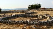
High on a hill near the Kouris River in the Limassol district of Cyprus sits Kantou Koufovounos, one of the island’s most significant Late Neolithic settlements. This archaeological site has quietly rewritten our understanding of life on Cyprus between 4,400 and 3,900 BC. Unlike the dramatic clifftop fortresses or coastal harbors that often capture imaginations, Kantou-Koufovounos was simply a community where people lived, worked, raised families, and built a society that lasted longer than many of its contemporary neighbors.

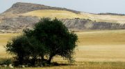
The site takes its name from Koufovounos Hill, where it rests approximately 20 to 50 centimeters below the modern ground surface. This shallow depth speaks to how close we still are to these ancient inhabitants. The settlement sits on the western bank of the Kouris River, positioned in terrain that offered natural protection while remaining accessible to vital resources.
Historical Background
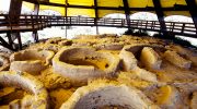
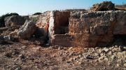
Excavations at Kantou-Koufovounos began in summer 1992 under the direction of the National and Kapodistrian University of Athens. This marked the first archaeological project the university undertook in Cyprus. The work continued through 1999, with additional periods in 1996, 1998, 2000, and 2001 dedicated to recording and studying the recovered materials. These careful excavations revealed rectangular residential units, storage pits, fire hearths, graves, and an extensive collection of stone tools.
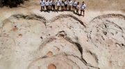
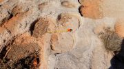
What makes this site particularly interesting is how much of it remains directly atop bedrock. The architectural features sit just above the natural stone foundation of the hill, creating excellent preservation conditions. Researchers found that many structures were built right on this bedrock surface, with minimal soil accumulation between ancient times and today.
In 1996, a geophysical survey team used magnetic surveying, soil resistivity prospecting, and electromagnetic techniques to map what remained hidden underground. This campaign covered 3,800 square meters, primarily on the southern side of the hill. The results revealed architectural features in the northern and southwestern sections, helping archaeologists plan future excavations and understand the settlement’s extent.
Life in the Late Neolithic Community
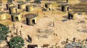
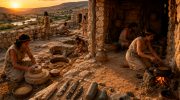
The people of Kantou-Koufovounos lived in rectangular houses, a departure from the circular structures common in earlier Cypriot settlements. These homes featured walls made of rubble and boulders, practical construction that took advantage of local materials. The settlement pattern suggests families organized themselves in clusters, with buildings grouped in what researchers describe as inward-looking arrangements.
Daily activities centered around food preparation, cooking, and craft production. Archaeological evidence shows these tasks took place both within individual homes and in shared spaces between structures. Fire hearths marked areas where families cooked meals and gathered for warmth. Storage pits preserved grains and other foods, while scattered stone tools tell stories of cutting, grinding, and shaping materials for everyday needs.
The settlement’s location was no accident. Positioned on elevated terrain with the Kouris River nearby, residents had access to fresh water, fertile soil for agriculture, and natural defensive advantages. The surrounding landscape provided game for hunting, while the river valley offered arable land for growing crops. Plant remains recovered from the site reveal what foods sustained this community across generations.
Cultural Connections Across the Island
Kantou-Koufovounos belongs to the Ceramic Neolithic period, when pottery first appeared in Cyprus. This technological advance marked a significant shift in how people stored, prepared, and consumed food. The ceramics found at the site show strong similarities to pottery from other settlements in southern Cyprus, particularly Sotira-Teppes and Khirokitia-Vounoi, all sharing what researchers call the Combed Ware tradition.
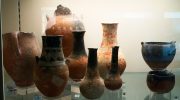
This uniformity in pottery styles suggests regular contact between communities across the island. Despite geographical distances, people maintained cultural connections through shared techniques and decorative preferences. Petrographic studies confirm that vessels were made locally using island clays, yet potters followed similar technical traditions whether they lived in the north or south of Cyprus.
Researchers have noted that Kantou-Koufovounos enjoyed a longer occupation than many contemporary sites. While settlements like Sotira-Teppes and Ayios Epiktitos-Vrysi were abandoned, Kantou-Koufovounos continued to thrive. This longevity hints at particular advantages the location offered or successful adaptations the community made to changing conditions.
What the Settlement Layout Reveals
Unlike some Neolithic sites that featured defensive walls, geophysical surveys found no evidence of fortifications surrounding Kantou-Koufovounos. The settlement apparently extended north, south, and west without enclosing barriers. This absence suggests either that defense was not a primary concern or that natural terrain features provided sufficient protection.
The architectural remains show considerable diversity in how buildings were used. Some smaller structures appear dedicated to productive activities rather than residence, while others display more elaborate construction and signs of intensive occupation. This variation indicates social complexity, with different households perhaps specializing in particular crafts or holding different status within the community.
Linear features detected in the southern portion of the surveyed area likely represent variations in the bedrock surface rather than built structures. These natural formations may have created a defensive border to the south, complemented by evidence of soil erosion that suggests the settlement concentrated more heavily on the northern slopes of the hill.
Modern Significance and Ongoing Research
The excavation and publication of Kantou-Koufovounos has filled important gaps in our understanding of Cypriot prehistory. The site demonstrates how Late Neolithic communities organized space, structured social relationships, and adapted to their environments. The detailed stratigraphic sequences preserved at the site allow researchers to track how practices and concepts changed over time within the same settlement.

Today, the modern village of Kantou continues to occupy the area near the ancient settlement. The village itself sits beside the Kouris River, not far from a dam built on one of its tributaries. While contemporary residents cultivate citrus, grapes, vegetables, carob, and cereals, they share the same landscape that sustained the Neolithic inhabitants thousands of years earlier.

Several Byzantine and later churches scattered through the area, including structures dating to the 15th and 16th centuries, demonstrate the long continuity of human presence here. The church of Agia Napa in the Kouris valley, the chapel of Chrysopolitissa, and the church of Agia Marina all testify to centuries of occupation following the Neolithic period.
Preserving the Archaeological Heritage
Future work at Kantou-Koufovounos includes mapping additional areas on the hillslope to fully understand the settlement’s boundaries. Researchers plan to overlay excavated regions onto geophysical maps, creating comprehensive documentation for site management and preservation. This integration of traditional excavation with modern remote sensing techniques provides a model for studying other prehistoric sites facing similar preservation challenges.
The excavations confirmed many features the geophysical surveys predicted. This success demonstrates how combining multiple investigation methods yields better results than relying on any single approach. The careful correlation between survey predictions and actual findings has provided valuable lessons for archaeological prospection throughout the eastern Mediterranean.
Kantou-Koufovounos stands as testimony to the sophisticated societies that flourished in Cyprus during the Late Neolithic period. The rectangular houses, organized settlement patterns, diverse craft production, and cultural connections with distant communities all point to a complex social world. These were not isolated villagers struggling for survival, but members of an island-wide network sharing technologies, ideas, and traditions across generations. The soil of Koufovounos Hill still holds many secrets about these ancient Cypriots, waiting for future researchers to uncover and interpret.