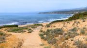
The scenic road from Platres to Prodromos traces one of the most beautiful routes in the Troodos Mountains. This approximately 18-kilometer drive connects two of Cyprus’s most significant mountain villages, winding through dense pine forests at elevations between 1,100 and 1,400 meters above sea level. The route offers travelers a chance to experience the island’s mountainous interior, where cool air and verdant landscapes contrast sharply with the coastal regions below.
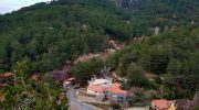
Platres sits at an altitude of 1,100 meters and serves as one of the largest resort villages in the Troodos range. Prodromos, positioned at 1,380 meters, holds the distinction of being the highest village in Cyprus. The road between them follows the natural contours of the mountain, revealing panoramic views of valleys, forests, and distant coastlines.
- Historical Routes and Mountain Connections
- Landscape and Natural Features Along the Route
- Notable Stops and Points of Interest
- Seasonal Changes and Weather Patterns
- Wildlife and Natural Environment
- Cultural Significance in Modern Cyprus
- Driving the Route and Practical Considerations
- What Makes This Drive Worth Taking
Historical Routes and Mountain Connections
The modern road between Platres and Prodromos has its roots in centuries-old paths that connected mountain communities. During the Byzantine period, these routes served monasteries and settlements that sought refuge in the highlands. Medieval maps show Prodromos marked as “Prodromo,” indicating its existence as a settlement during that era.
By the late 19th century, British colonial administrators recognized the Troodos Mountains as an ideal summer retreat from the coastal heat. They developed road infrastructure that linked villages such as Platres and Prodromos, transforming them into popular destinations for government officials and wealthy families. The road network expanded gradually through the 20th century, creating the scenic routes that exist today.
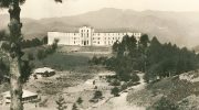
The route passes through areas that have witnessed Cyprus’s social and political changes. The abandoned Berengaria Hotel in Prodromos, built in the 1930s, once attracted prominent international figures. The road itself became a vital connection for communities that expanded their economies from agriculture to tourism.
Landscape and Natural Features Along the Route
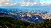
The drive presents a constantly changing natural environment. Departing from Platres, the road climbs through a mixed forest dominated by black pine trees. These pines, scientifically known as Pinus nigra subspecies pallasiana, cover vast stretches of the mountainside and create dense shade over the roadway.
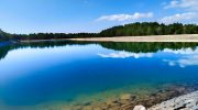
The route follows the Troodos-Prodromos road, which runs parallel to several nature trails. To the east lies the Prodromos Dam, visible from certain vantage points along the drive. This reservoir sits at approximately 1,400 meters elevation and serves as both a water source and recreational area surrounded by picnic sites.
Between the villages, drivers encounter several geographical markers. The terrain shifts from the relatively steep slopes near Platres to more gradual inclines as the road approaches Prodromos. Golden oak trees appear alongside the pines, particularly in areas where elevation and soil conditions favor their growth.
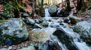
The road also passes near the headwaters of the Kryos Potamos River, which flows downward toward Platres. This cold mountain stream feeds the famous Caledonia Waterfall, located about one kilometer from the main road on a hiking trail that begins near the Psilo Dendro restaurant.
Notable Stops and Points of Interest
Several significant locations mark the route between these two villages. About five kilometers from Platres, travelers reach Troodos Square, the central hub of the mountain resort area. This junction sits at 1,750 meters and provides access to Mount Olympus, Cyprus’s highest peak at 1,952 meters.
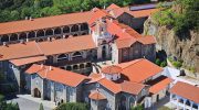
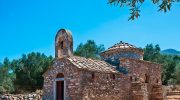
The Monastery of Panagia Trooditissa lies approximately five kilometers northwest of Platres, accessible via a side road. This Byzantine monastery dates back centuries and remains active as a religious site. Its location in a forested valley provides a peaceful setting distinct from the main mountain road.

Further along toward Prodromos, the road passes close to several marked nature trails. The Prodromos-Zoumi trail begins near the village and extends three kilometers through pine forest with views across the Marathasa valley. The Fragma Prodromou picnic site near the dam offers facilities for visitors who wish to stop and explore on foot.
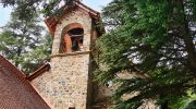
Within Prodromos village, the church of Ioannis Prodromos serves as the community’s focal point. The current structure dates to 1935, replacing an earlier 13th-century building. Nearby stand the chapel of Agios Onoufrios, a 14th-century structure, and the chapel of the Holy Trinity from 1931.
Seasonal Changes and Weather Patterns
The climate along this mountain route varies dramatically throughout the year. Summer months bring mild temperatures that rarely exceed 25 degrees Celsius, making the drive comfortable even during midday. The pine forests provide additional cooling effect, and many areas of the road pass through shaded sections.
Autumn transforms the landscape as deciduous trees change color. Golden oaks turn bronze and yellow, creating contrast against the evergreen pines. This season also brings increased rainfall, which fills mountain streams and makes waterfalls more impressive.

Winter conditions can be challenging. Snow commonly blankets the region from December through February, and roads may require chains or four-wheel-drive vehicles. The ski center on Mount Olympus operates during these months, attracting visitors to the area. However, the scenic beauty of snow-covered pine forests makes winter drives particularly memorable for those prepared for mountain conditions.
Spring sees wildflowers blooming along roadsides and in forest clearings. Endemic plants such as Troodos sage and purple rock cress appear on hillsides. The melting snow increases water flow in streams, and birds become more active after the winter months.
Wildlife and Natural Environment
The forests along the Platres-Prodromos route support diverse wildlife. Fox, hare, and hedgehog inhabit the woodlands, though they are rarely seen from vehicles. The endangered Cyprus mouflon, a wild sheep species, lives in these mountains, though sightings are uncommon near the main road.

Bird species are more frequently observed. Bonelli’s eagle soars over the mountainsides, while Eurasian jays, wood pigeons, and partridges inhabit the forests. Endemic species include the Cyprus warbler and Cyprus wheatear, which breed in these highlands. Common ravens and hooded crows appear throughout the year.
The forests themselves contain significant botanical diversity. Beyond the dominant black pines, the area hosts the Troodos catmint, Cyprus germander, and Troodos alison. These endemic plants grow in specific altitude ranges and soil types found along the mountain route.
Cultural Significance in Modern Cyprus
This mountain road represents more than a physical connection between villages. It embodies the Cypriot relationship with the Troodos Mountains, which have served as refuge, resource, and recreation for generations. The route passes through landscape that shaped the island’s cultural identity.
For modern Cypriots, the drive offers escape from summer heat and urban life. Weekend visitors from Limassol and Nicosia travel these roads seeking cooler temperatures and natural surroundings. Platres and Prodromos have maintained their appeal as mountain retreats, though permanent populations in both villages have declined.
The road also connects to Cyprus’s agricultural heritage. The villages along the route historically produced wine, cherries, and other mountain crops. While tourism now dominates local economies, some traditional activities continue. Platres still produces wine, and cherry trees bloom throughout the area in spring.
Religious pilgrimage remains important. The monasteries and churches scattered through these mountains attract visitors year-round. The road provides access to sites of Orthodox Christian significance that have existed for centuries.
Driving the Route and Practical Considerations
The drive from Platres to Prodromos typically takes 30 to 45 minutes without stops, though the journey rewards those who allow more time. The road is paved and well-maintained, though narrow sections require careful attention. Numerous curves demand reduced speed, particularly when weather conditions are poor.

From Platres, the route initially follows the road toward Troodos Square. Drivers pass the Psilo Dendro trout farm and restaurant, a landmark that marks the beginning of the Caledonia trail. The road climbs steadily through pine forest, with occasional openings that provide views across valleys.
Several parking areas and viewpoints allow travelers to stop safely. The Troodos Square area offers facilities, restaurants, and shops. Closer to Prodromos, the dam picnic area provides tables and basic amenities. During peak summer weekends, these spots can be crowded, so visiting during weekdays or off-season provides a quieter experience.
Public transportation exists but operates on limited schedules. Bus number 81 connects towns in the region, though checking current timetables is essential. Most visitors drive private vehicles, allowing flexibility to explore side roads and trails.
What Makes This Drive Worth Taking
The Platres to Prodromos scenic road offers a concentrated experience of what makes the Troodos Mountains distinctive in Cyprus. It passes through Cyprus’s highest inhabited areas, where ecology and climate differ fundamentally from the lowlands. The route provides access to natural beauty, historical sites, and mountain culture within a manageable distance.
This drive connects visitors to the island’s interior identity. While beaches and ancient ruins attract most tourism, the mountains represent another essential aspect of Cyprus. The cool forests, endemic species, Byzantine heritage, and village traditions found along this road reveal the diversity that exists within this Mediterranean island.
The journey between these two villages demonstrates how geography shapes human settlement and culture. The road itself, built to connect mountain communities, now serves as gateway to understanding the Troodos region’s significance in Cypriot life, past and present.