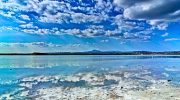
Cyprus offers some of the Mediterranean’s most spectacular coastal drives. The island’s shoreline stretches across hundreds of kilometers, combining turquoise waters with dramatic cliffs, hidden coves, and beaches rich in mythology. These routes showcase Cyprus’s natural beauty while connecting historical sites, traditional villages, and protected nature areas.
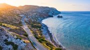
The B6 coastal road between Paphos and Limassol provides one of Cyprus’s most scenic drives. This route covers approximately 70 kilometers and takes about 90 minutes without stops, though the attractions along the way deserve considerably more time. The parallel A6 motorway offers faster travel, but the B6 keeps drivers closer to the coastline for better sea views.
The route’s highlight arrives at Petra tou Romiou, known internationally as Aphrodite’s Rock. Located roughly 25 kilometers from Paphos, this dramatic sea stack marks the mythological birthplace of Aphrodite, goddess of love and beauty. According to legend, she emerged from sea foam near these distinctive limestone formations. The rough waters around the rocks create spectacular white foam, particularly during winter months when waves crash against the coastal cliffs.
Governor’s Beach, located near Pentakomo village between Limassol and the Akrotiri Peninsula, features distinctive chalk-white rock formations extending into the sea. The area includes multiple small coves separated by these limestone cliffs, creating private swimming spots popular with both locals and tourists. The contrast between white rocks and deep blue water provides striking natural scenery.
Exploring the Wild Akamas Peninsula
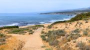
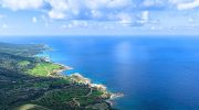
The northwestern Akamas Peninsula offers Cyprus’s most rugged and untouched coastal scenery. This protected area covers 230 square kilometers of forest, valleys, gorges, and pristine coastline. Unlike the developed southern beaches, Akamas remains largely natural, accessible only via 4×4 vehicles, ATVs, or boats beyond the paved access roads.
The drive typically begins from Polis Chrysochous or the small harbor village of Latchi. Paved roads reach the Baths of Aphrodite, a natural grotto where mythology claims the goddess bathed and first met her lover Adonis. From this tourist information point, only dirt tracks continue deeper into the peninsula, requiring appropriate vehicles.
The coastal route to Fontana Amorosa Beach covers approximately 12 kilometers of rough terrain. The beach’s name, meaning “source of love” in Italian, reflects its connection to Aphrodite mythology. Despite the challenging access, visitors prize this remote beach for its crystal-clear turquoise waters and untouched natural setting.
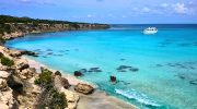
The Blue Lagoon represents Akamas’s most photographed location. This natural bay features impossibly clear waters in shades of turquoise and deep blue, surrounded by rugged coastal cliffs. The lagoon sits in the heart of Akamas National Park and attracts boat tours from Latchi harbor. Swimming and snorkeling here reveal underwater rock formations and diverse marine life.
Lara Beach on the peninsula’s western side serves as a nesting ground for loggerhead and green sea turtles. The beach remains undeveloped to protect these endangered species. Access requires 4×4 vehicles traversing approximately 11 kilometers of dirt roads from the main fork in Akamas. Conservation efforts limit visitor numbers during nesting season between May and October.
The Eastern Coastal Run to Cape Greco

The eastern coast from Larnaca to Ayia Napa features a different character than the western routes. The A3 motorway provides the main connection, but coastal B-roads offer better sea access and beach stops. This route passes through multiple resort areas before reaching Cape Greco National Forest Park.
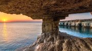
Cape Greco sits on the southeastern tip of Cyprus, where dramatic sea cliffs plunge into the Mediterranean. The park covers a small peninsula featuring sea caves, natural rock bridges, and hidden swimming coves accessible only by boat or hiking trails. The area attracts snorkelers and divers exploring underwater cave systems.
Multiple viewpoints along the Cape Greco coastal road offer panoramic vistas of the coastline stretching toward Protaras and Ayia Napa. The famous sea caves near Ayia Napa include formations where sunlight filters through openings in the rock ceiling, creating natural light shows on the water surface.
The Northern Coast Through Kyrenia Region
Northern Cyprus offers equally spectacular but less crowded coastal routes. The drive from Kyrenia eastward along the Karpas Peninsula reveals untouched beaches and traditional villages. Golden Beach at the peninsula’s eastern tip features several kilometers of undeveloped sand dunes where wild donkeys roam freely.
The coastal road passes 5th-century basilica ruins at Sipahi and leads to Kantara Castle, where ramparts provide sweeping views across the coastline. Byzantine churches with preserved frescos dot the route, including the Antifonitis Church near Bahçeli village.
This northern route requires crossing from the Republic of Cyprus through one of seven checkpoints along the Green Line. Rental cars from southern Cyprus cannot legally cross to the north, complicating access for many tourists. Those who make the journey find less developed beaches and authentic fishing villages maintaining traditional character.
Practical Considerations for Coastal Driving
Cyprus follows left-hand traffic, requiring continental European and North American drivers to adjust their lane positioning. Speed limits drop to 50 or 65 kilometers per hour in villages, with police actively enforcing restrictions through cameras and mobile units.

Coastal roads vary dramatically in quality. Major routes like the B6 feature excellent pavement and clear signage. Akamas Peninsula tracks require high-clearance 4×4 vehicles, while some beach access roads remain unpaved or poorly maintained. Rental car insurance often excludes coverage for dirt road driving, creating potential liability issues.

Summer temperatures regularly exceed 35 degrees Celsius, making air conditioning essential for coastal drives. Fuel stations appear regularly along main routes but become scarce in remote areas like Akamas or the Karpas Peninsula. Drivers should refuel before venturing into these regions.
Parking at popular beaches fills rapidly during July and August peak season. Early morning arrivals secure spaces and avoid the hottest midday hours. Many coastal attractions provide free parking, though some charge nominal fees during summer months.
Why Coastal Routes Define the Cyprus Experience
The island’s coastline combines natural beauty with deep cultural connections. Every beach and rock formation carries mythology linking the landscape to ancient gods and heroes. This merger of physical geography and cultural memory creates destinations offering more than simple scenic value.
Coastal drives allow independent exploration at personal pace, stopping wherever interesting features appear. Unlike organized tours following fixed schedules, self-drive routes accommodate spontaneous detours to unmarked beaches or village tavernas serving fresh seafood.

Environmental protection efforts preserve pristine areas like Akamas and Lara Beach from development pressures affecting southern resort zones. These protected coastlines offer glimpses of how Cyprus appeared before mass tourism, maintaining ecological value alongside aesthetic appeal. The diversity of coastal routes ensures every visitor finds suitable drives matching their preferences, vehicle capabilities, and available time.