The Papoutsa Nature Trail represents a significant high-altitude route within the Pitsilia region of Cyprus. This path climbs toward the summit of Mount Papoutsa, which stands as the third-highest peak on the island. Hikers traverse a landscape defined by rugged volcanic rock and sparse mountain vegetation.
The environment around this trail features a unique mix of endemic plants and geological formations. Local history connects this mountain to the traditional life of the nearby villages like Palaichori and Agros. This area serves as a vital water catchment zone for the southern plains of the island.
Visitors encounter a quiet atmosphere that contrasts with the busy coastal resorts. The trail offers a clear view of the surrounding valleys and the distant sea on clear days. This path is a testament to the raw and unyielding beauty of the Cypriot interior mountains.
Trail Overview
- Location: Near Palaichori Village, Pitsilia Region, Cyprus
- Distance: 4.3 miles (7 km)
- Route Type: Out & Back
- Difficulty: Hard
- Elevation Gain: 550 meters
- Duration: 3 – 4 hours
- Best Time to Visit: March – May and September – November
- Terrain: Rocky, steep mountain slopes, and dirt tracks
Geological Composition and Volcanic Origins
The ground beneath the Papoutsa Nature Trail consists of ancient volcanic material from the Troodos ophiolite complex. This rock formed millions of years ago on the deep ocean floor before tectonic forces pushed it upward. The dark gabbro and diabase rocks create a stark and dramatic appearance on the slopes. These minerals provide a stable but rough surface for the path.
The soil is thin and rocky because the steep incline leads to constant erosion. Geologists value this site because it reveals the internal structure of the Earth’s crust. Each step on the ascent reveals different layers of stone that vary in color and texture. The presence of iron and copper in the rock sometimes creates a rusty red hue on the cliffs. This geological diversity is a primary feature of the Pitsilia mountain range.
Flora and Endemic Plant Life
The vegetation on Mount Papoutsa adapts to the high altitude and the intense sun. Low shrubs like the prickly burnet and the rock rose dominate the lower sections of the trail. These plants have small leaves to minimize water loss during the dry summer months. As the elevation increases, you see more specialized species like the Cyprus crocus and local orchids.
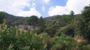
The golden oak also grows in small clusters within the more sheltered gullies. This tree is a national symbol of Cyprus, and it thrives in the volcanic soil of the mountains. Aromatic herbs like wild thyme and lavender grow in the cracks between the rocks. These plants release a strong scent when the sun warms the mountain air. The lack of dense forest allows these smaller plants to receive full sunlight throughout the day.
Avian Diversity and Mountain Wildlife
The open landscape of the Papoutsa Nature Trail is an ideal habitat for birds of prey. The Bonelli’s eagle is a frequent sight as it hunts for small mammals across the rocky slopes. This bird is a rare and protected species that finds safety in the high cliffs of the Troodos range. Smaller birds like the Cyprus wheatear use the rocks as perches while they search for insects.

The lack of tall trees makes it easy for birdwatchers to spot these creatures in their natural environment. Local mammals like the fox and the Cyprus hare also inhabit the mountain. These animals are mostly active during the dawn and dusk hours to avoid the midday heat. The insect life is equally vibrant with many butterflies that migrate through the mountain passes in the spring.
Climatic Conditions and Hiking Hazards
The weather on the Papoutsa Nature Trail is far more extreme than the coastal regions. Temperatures can drop below freezing during the winter and snow often covers the summit. This creates a beautiful but dangerous environment for those who do not have the right gear. In the summer the heat is intense and there is almost no shade on the trail. This makes it vital for hikers to start their journey very early in the morning.
Strong winds often sweep across the ridges and can make the steep sections more difficult to navigate. Visibility can change quickly if clouds move in from the sea. Hikers must stay alert to these changes to ensure a safe return to the village. The air at this altitude is thin and crisp which adds to the physical challenge of the climb.
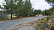
Connectivity to the Village of Palaichori
The trail starts near the historic village of Palaichori which offers a glimpse into traditional Cypriot life. This village is famous for its stone houses and narrow paved streets. After a long hike many people return to the village square to rest and eat. The local taverns serve food that comes directly from the surrounding farms.
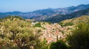
This economic link between the trail and the village is important for the local community. The residents take pride in their mountain and often help to maintain the markers on the path. This hospitality is a key part of the experience for any visitor to the region. The proximity of the village makes the trail a convenient choice for a day trip from Nicosia or Limassol.
Architectural Features and Mountain Masonry
Along the path you will find several examples of traditional mountain architecture. Small stone shelters provide a place for shepherds to rest during the winter. These structures use the same volcanic rock that makes up the mountain. The skill required to build these huts without modern tools is remarkable.
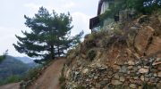
You will also see ancient terraces that once supported vines and fruit trees. Although many are now abandoned they still hold the soil in place and prevent erosion. These man made features blend perfectly with the natural environment. They serve as a reminder of a time when the mountain was a place of active labor. The trail preserves these historical elements for future generations to study.
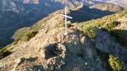
Panoramic Views and Visual Perspectives
The main draw of the Papoutsa Nature Trail is the unobstructed view from the top. From the summit you can see the entire Troodos range to the west. On the opposite side the hills of Pitsilia roll down toward the southern coast. The Machairas forest is also visible to the east with its dark green pine trees.
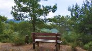
The contrast between the dark rock and the blue sky is a favorite subject for photographers. These vistas provide a sense of the scale and geography of the island. The sight of the distant sea serves as a reminder of how small the island truly is. This visual reward makes the difficult climb worth the effort for every hiker.


