The Panthea Nature Trail is one of the most serene and visually spectacular hiking routes nestled within the high-elevation forests of Cyprus. Situated in the Nicosia District, the trail begins on the mountain pass between the world-famous Kykkos Monastery and the secluded village of Tsakkistra.
Unlike the coastal walking paths of Cyprus, the Panthea trail immerses hikers in dense stands of pine trees, leading them along sharp ridges that offer sweeping views of the surrounding valleys. The trail serves as a physical link between isolated mountain communities, providing a peaceful escape for those looking to experience the authentic, untamed interior of the island.
Panthea Nature Trail Overview
- Location: Road between Kykkos and Tsakkistra, Nicosia District, Western Cyprus.
- Distance: 10.1 kilometers (6.3 miles) for the full linear trail; there is also a popular 7.2-kilometer (4.5 miles) out-and-back variation.
- Route Type: Linear (can be walked one-way or out-and-back).
- Difficulty: Category 2 (Moderate/Difficult) due to sudden gradient changes and narrow sections.
- Elevation Gain: Approximately 413 meters (1,355 feet).
- Duration: 3 to 3.5 hours for a one-way walk, or 4+ hours for an out-and-back.
- Best Time to Visit: Winter and Spring (December to April) for peak visibility, cool weather, and blooming orchards.
- Terrain: Narrow dirt footpaths along high mountain ridgelines, transitioning to weathered gravel forest roads.
The Geography and Setting of the Panthea Region
To fully understand the landscape of the Panthea Nature Trail, one must look at the remote geography of the Troodos mountain range’s northwestern slopes. The trail sits high above the sea, reaching a maximum altitude of 1,061 meters (3,481 feet) above sea level. It cuts through the northeastern reaches of the Paphos Forest, an expansive protected reserve known for its rugged volcanic peaks and deep river valleys.
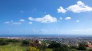
The trail winds along the high mountain crests that divide the Tsakkistra and Kampos valleys. These valleys are carved by the Xeros and Kampos rivers, creating dramatic drops on either side of the trail. The elevation ensures a cool, crisp mountain climate. This makes the area a sharp contrast to the sun-baked plains of Nicosia or the humid coastlines of Paphos and Limassol.
Geologically, the region is characterized by weathered igneous rock and thin, stony topsoil. This creates a challenging environment where only highly adapted flora can thrive. The trail utilizes a combination of historic pathways once used by local loggers and forestry workers, as well as unpaved dirt tracks that have been maintained by the Forestry Department of the Republic of Cyprus.
Flora and Fauna Along the Trail
The high altitude and dense tree cover make the Panthea Nature Trail a critical habitat for native Cypriot wildlife and plant species. The trail begins under a heavy canopy of Calabrian pine (Pinus brutia), which dominates the lower and middle elevations of the forest. As hikers ascend along the ridgeline, the forest opens up, revealing a rich understory of Mediterranean scrub.
Plant Life and Agriculture
- Native Forest: In addition to the Calabrian pine, hikers will encounter golden oaks (Quercus alnifolia) and strawberry trees (Arbutus andrachne), whose striking reddish bark stands out against the green foliage.
- Orchards: Toward the end of the trail near the village of Kampos, the wild forest transitions into cultivated land. The route passes directly through local cherry and apple plantations. In the spring, these orchards burst into delicate white and pink blossoms, adding a fragrant and colorful element to the hike.
- Wildflowers: Early spring brings out a variety of ground-level flora, including wild orchids, endemic purple cyclamens, and yellow gorse bushes that line the narrow dirt paths.
Wildlife and Birdwatching
The deep, quiet valleys flanking the Panthea trail provide a sanctuary for various animal species. Bird enthusiasts should keep a sharp eye on the sky, as the high ridgelines offer perfect thermal currents for birds of prey.
- Avian Species: It is common to spot the majestic Bonelli’s eagle or the Eurasian sparrowhawk gliding over the Xeros valley. In the dense pine branches, hikers can hear the distinct calls of the coal tit and the endemic Cyprus wheatear.
- Mammals: While shy and rarely seen during the day, the Cyprus Mouflon (Ovis orientalis ophion)—the island’s endemic wild sheep—inhabits the surrounding Paphos Forest. Early morning hikers may occasionally spot their tracks along the softer sections of the dirt paths.
Detailed Walkthrough and Route Options
The Panthea Nature Trail is a linear trail, meaning it does not loop back to the starting point on its own. To complete it, hikers either need to arrange transportation at the end, or turn back at the halfway point for an out-and-back hike.
The Starting Point and Ridgeline Ascent

The official trailhead is located on the road connecting Kykkos to Tsakkistra. It is marked by a wooden refuge shelter that sits under the dense canopy of the forest. This rustic shelter acts as an excellent staging ground where hikers can review the map and adjust their gear.
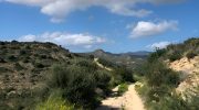
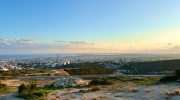
The first 1.5 kilometers of the walk is widely considered the most spectacular part of the trail. The route consists of a narrow, single-file footpath that traces the high ridgeline of the mountain. Because there are steep drops on either side, hikers are treated to uninterrupted 360-degree panoramic views. On a clear winter or spring day, you can look down over the twin mountain villages of Tsakkistra and Kampos nestled in the valleys below.
The High Crests and the Logging Junction
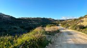
After leaving the initial ridgeline, the trail begins to widen into a weathered, gravel-strewn road. This section was historically used by forestry workers and loggers to transport timber out of the Paphos Forest. Though it lacks the rugged charm of a narrow footpath, this stretch allows hikers to pick up their pace while walking through towering pine trees.
A few kilometers into the hike, the trail reaches a major intersection where the Panthea trail crosses paths with the historic Loggers Trail. At this junction, clear wooden signage directs hikers toward their chosen destination. Hikers can decide whether to descend toward the village of Tsakkistra or continue toward the village of Kampos.
The Final Descent to Kampos
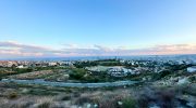
If hikers follow the primary route toward Kampos, the trail begins a steady and continuous descent. The gravel path winds down the mountain slopes, passing through terraced cherry and apple orchards. The sound of the wind rustling through the pines is gradually replaced by the sounds of rural village life. The trail officially terminates just outside the community of Kampos, where hikers can rest after completing the 10.1-kilometer trek.


