Two Festivals, One Island
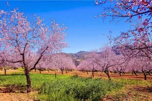
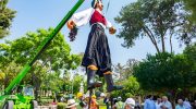
Cyprus expresses its culture best when it gathers people together in public spaces, after sunset, with music in the air and tradition close at hand. Two annual festivals capture this instinct especially clearly: the Limassol Wine Festival and the Ayia Napa International Festival. Though different in tone and setting, they reveal how Cyprus balances heritage and openness, local pride and global exchange. Experiencing them side by side offers a clear insight into how celebration functions as a cultural language on the island. Two Ways of Telling the Same Story At first glance, these festivals appear to represent different worlds. Limassol's event revolves around wine, harvest traditions, and large-scale public gatherings, while Ayia Napa's focuses on music, performance, and international cultural exchange. Yet both serve the same purpose: they turn shared space into shared identity. Limassol’s festival unfolds in a broad seaside garden, encouraging movement, conversation, and repetition. Ayia Napa’s festival concentrates activity in a historic square, drawing attention inward toward performance and spectacle. One spreads outward, the other gathers inward, but both rely on the same idea that culture becomes meaningful when it is experienced collectively. Why These Festivals Were Created in the First Place Neither festival began as a decorative addition to the calendar. Each emerged from a practical and cultural need. The first Limassol Wine Festival was held…
Read more