The Green Line takes its name from a green chinagraph pencil used by British Major General Peter Young on December 30, 1963. He drew a ceasefire line on a map of Nicosia during a twelve-hour meeting following intercommunal violence between Greek and Turkish Cypriots. That pencil mark became the basis for one of Europe’s most visible political divisions.
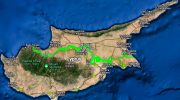
Today the Green Line stretches 180 kilometers from Kato Pyrgos in the west to Paralimni in the east, cutting across the entire island. It varies from just 3.3 meters wide in central Nicosia to 7.4 kilometers wide in rural areas. The buffer zone covers 346 square kilometers, roughly 3.7 percent of Cyprus’s total land area. After the Berlin Wall fell in 1989, Nicosia became the last divided capital city in the world, a distinction it still holds.
From Pencil Line to Military Frontier
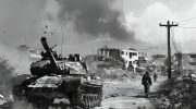
The original 1963 Green Line addressed only Nicosia and remained relatively informal. The 1974 Turkish invasion changed everything permanently. Following a coup attempt by Greek Cypriot nationalists seeking union with Greece, Turkey intervened militarily and captured approximately 37 percent of the island. The ceasefire of August 16, 1974, froze the front lines in place. These lines became the boundaries of the current buffer zone, with the Turkish army holding the north and the Republic of Cyprus controlling the south.
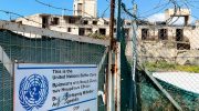
The United Nations Peacekeeping Force in Cyprus, known as UNFICYP, took responsibility for patrolling the zone. Turkey built barriers on the northern side including barbed wire fencing, concrete wall segments, watchtowers, and anti-tank ditches. Some areas still contain thousands of landmines. In the first seven years of a clearance project, workers removed over 27,000 land mines and declared 81 minefields clear.
What the Buffer Zone Looks Like Now
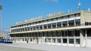
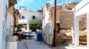
The buffer zone contains some of the most unusual landscapes in Europe. In central Nicosia, abandoned buildings from 1974 slowly crumble just meters from busy shopping streets. Cars parked when their owners fled in 1974 remain on the same spots five decades later. An underground garage still holds 1970s vehicles that were new when the invasion occurred. The abandoned Nicosia International Airport stopped operating in 1974 and remains frozen in time within the zone, with UNFICYP using it as their headquarters.
Elsewhere the zone looks entirely different. Wide agricultural areas allow farming with proper UN permits. Forests and scrubland have grown undisturbed for fifty years, creating unintentional wildlife corridors that support biodiversity including birds, foxes, and plant species. The village of Pyla sits within the buffer zone on the east side and remains the only settlement in Cyprus where Greek Cypriots and Turkish Cypriots still live side by side, governed by the Republic of Cyprus but policed by the UN.
Crossing Opened in 2003 and Changed Daily Life
For nearly thirty years after 1974, crossing the Green Line was virtually impossible for most people. This changed on April 23, 2003, when the Turkish Cypriot administration opened crossings for the first time, allowing Greek Cypriots to cross to the north and Turkish Cypriots to visit the south. The emotional scenes of families visiting their former homes and villages made international news. Nine crossing points now operate across the island.
In Nicosia, the Ledra Street crossing opened in April 2008 as a pedestrian-only route through the heart of the old city. Ledra Palace crossing handles both pedestrians and diplomatic vehicles. Agios Dometios serves as the main road crossing in Nicosia. Additional crossings at Astromeritis, Pyrgos Limnitis, Pergamos, Strovilia, Dherynia, and Lefka serve different regions. Two eastern crossings at Dherynia and Lefka opened simultaneously in November 2018 for the first time in eight years.
Practical Rules for Crossing Today
Anyone can cross the Green Line in either direction with a valid passport. Citizens of any country, including Greek and Turkish Cypriots, may use all crossing points. A separate sheet is provided at checkpoints for entering passport details. Visitors may take rental cars through most crossings but should check with their hire company first regarding insurance requirements, as additional coverage is available at checkpoints. Ledra Palace and Ledra Street crossings are pedestrian only.
The Republic of Cyprus conducts identification checks on people entering from the north but maintains no formal immigration checkpoint. One critical rule applies to all visitors: Visitor cannot enter Cyprus through the north and exit through the south or vice versa, as doing so means visitor has entered the Republic of Cyprus illegally from a border it does not recognize. Visitors must always enter and exit through the same side. Cyprus joined the European Union in 2004, and EU regulation 866/2004 removed restrictions on EU citizens, meaning Europeans can cross freely.
Varosha Remains a Symbol of the Frozen Conflict
Varosha, the former tourist district of Famagusta, ranks as the most famous symbol of the division. Once one of the most popular holiday destinations in the Mediterranean, Varosha emptied within hours when its 45,000 residents fled in August 1974. The Turkish military sealed the area immediately and it remained completely closed for decades. Buildings began collapsing through neglect while nature gradually reclaimed streets and gardens.

In 2020, Turkish authorities partially reopened a section of Varosha beach for the first time in 46 years, a move the United Nations Security Council called deplorable. The Republic of Cyprus and Greek Cypriot community regard the reopening as a violation of UN resolutions. International reaction was largely critical. The ghost town remains controversial and the fate of displaced residents who lost everything there remains unresolved.
The Human Cost Behind the Statistics
Over 200,000 Greek Cypriots fled or were expelled from the north in 1974, and over 40,000 Turkish Cypriots left the south. Some 1,500 people went missing during the conflict and their fate remained unknown for decades. The Committee on Missing Persons has since identified over 1,100 of these individuals through DNA analysis. Many families only learned the fate of relatives after fifty years.
Property claims by displaced persons represent one of the most complex obstacles to any future settlement. Tens of thousands of people hold title deeds to homes and land they have not accessed for five decades. The emotional weight of this unresolved situation shapes political attitudes on both sides, making compromise difficult even when negotiators come close to agreement.
The Green Line’s Lasting Legacy
The Green Line continues shaping daily life on an island of only 1.2 million people. Thousands of Cypriots regularly cross to work, shop, and visit. Turkish Cypriots cross south for better paid employment, healthcare, and services available in the EU member state. Greek Cypriots cross north to visit former family homes, explore historic sites, or simply experience a different part of their own country.
The zone itself has generated unexpected benefits including wildlife preservation, cultural heritage frozen in time, and tourism interest.
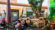
Nicosia’s division creates a unique city where visitors can walk between two political worlds in minutes. The ongoing UN mission, one of the longest running peacekeeping operations in history, keeps the peace while reunification talks continue without resolution. The future of the Green Line remains entirely uncertain, making Cyprus one of Europe’s most politically unresolved places more than fifty years after that pencil line divided the island.