Explore Cyprus with Our Interactive Map

Explore our top stories and discover ideas worth your time.

Veined Sainfoin of Cyprus

Veined Sainfoin of Cyprus

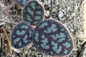
In the sunny landscapes of Cyprus, a little plant called veined sainfoin (Onobrychis venosa) adds pops of pink to rocky hillsides. This endemic wildflower, unique to the island, thrives in tough spots and has a story tied to Cyprus's natural history. But what makes its veiny leaves and blossoms so special? What Exactly Is This Charming Cypriot Wildflower? Onobrychis venosa is a small, wild herb that's part of the legume family, like peas or beans. It's a perennial plant, meaning it comes back year after year, and it's found only in Cyprus, making it a true island native. How Did This Plant Bloom from Cyprus's Ancient Soils? The origins of Onobrychis venosa trace back to the island's geological past, where tectonic shifts and volcanic activity created diverse habitats over millions of years. First described in the early 19th century by botanists Desfontaines and Desvaux, it was named for its distinctive veined appearance. As Cyprus evolved in isolation in the Mediterranean, this plant adapted to dry, bushy slopes, becoming one of the island's endemic treasures. Picture This: A Low-Growing Beauty with Striking Veins This herb grows just 10 cm tall, spreading out wide with a short stem and alternate leaves that are compound and feather-like, marked by prominent veins that give it a textured look. Its flowers cluster in spikes, blooming…

Read more
Best Inland Mountain Routes Across Cyprus

Best Inland Mountain Routes Across Cyprus

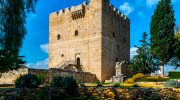
The Troodos Mountains cover one-third of Cyprus and rise to 1,952 meters at Mount Olympus. This massive range stretches across most of the western side of the island, offering cool pine-scented air, traditional villages, and winding roads that climb from sea level through multiple climate zones. These mountain routes provide a complete contrast to coastal Cyprus, both in landscape and atmosphere. Three main routes connect Nicosia to the Troodos region, each offering distinct scenery and driving experiences. The most scenic path runs through Evrychou, Galata, Kakopetria, Platania, outside Kyperounta, Amiantos, and finally Platia Troodos. This route covers approximately 100 kilometers and takes between 90 minutes to two hours depending on traffic and stops. The road features numerous curves and requires careful navigation, particularly for drivers unfamiliar with mountain conditions. Passing slower vehicles can be challenging on narrow sections, but the pure mountain driving experience rewards those who enjoy the combination of concentration and scenery. During winter months, heavy snow can make this route impassable without 4x4 vehicles or tire chains. An alternative loops through Kalopanagiotis, Moutoullas, Pedoulas, and Prodromos before reaching Platia Troodos. This variation offers incredible scenery through the Marathasa Valley but comes with very narrow roads. The decorative walls along village streets create a distinctive character, though roadside parking by tourists can slow progress considerably. The third option…

Read more

Cape Greco National Forest Park

Cape Greco National Forest Park

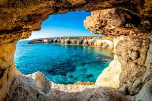
Cape Greco National Forest Park occupies 385 hectares on a rocky promontory at the southeastern tip of Cyprus, nestled between the resorts of Ayia Napa and Protaras. The park was designated as a National Forest Park in 1993 to protect this area of unspoiled natural beauty. The broader Natura 2000 site encompasses 1,876 hectares, including 915 hectares of terrestrial area and 961 hectares of marine zones. The dramatic limestone cliffs rise 30 feet above turquoise Mediterranean waters, creating spectacular coastal scenery. Sea caves carved by thousands of years of wave action punctuate the coastline, while natural rock arches frame views of the endless blue horizon. The park combines hiking trails, cycling paths, endemic plant species, and coastal beauty in a relatively compact area. Visitors experience Cyprus at its wildest and most beautiful, with pine scented paths overlooking crystal clear waters. The lost juniper forest and current vegetation Cape Greco was originally covered by a dense juniper forest that gave the area its distinctive character. Between 1910 and 1920, these trees were rapidly cut down and burned to power steam flour mills that operated in abundance in the Paralimni area. Since then the slow growing juniper has never fully recovered, though scattered specimens still survive alongside varieties of pine. Today the vegetation consists mostly of sparse low level growth, including 14…

Read more