Explore Cyprus with Our Interactive Map

Explore our top stories and discover ideas worth your time.

Sanctuary of the Great Mother (Avdimou)

Sanctuary of the Great Mother (Avdimou)

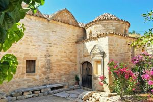
The Sanctuary of the Great Mother in Avdimou represents a timeless spiritual hub in Cyprus, where ancient veneration of a fertility female entity evolved into a more recent devotion to a maternal figure. Located in the rural village of Prastio Avdimou near the south coast, this site embodies the island's layered spiritual history, blending prehistoric fertility traditions with medieval and later cultural practices. It highlights Cyprus's role as a crossroads of civilizations, where early rites centered on life, birth, and renewal transitioned into the local respect for a central mother figure, fostering an enduring tradition of pilgrimage and regional devotion that persists today. A Cult Site of Continuity The Sanctuary of the Great Mother, embodied in the historical stone structure in Prastio Avdimou, stands as a testament to Cyprus's spiritual evolution, nestled in a serene valley amid olive groves and rolling hills. This site, spanning less than a hectare but rich in symbolic depth, draws from prehistoric roots where fertility figures were honored for their power over life and nature. In ancient times, Cypriots revered a "Great Goddess" depicted in cruciform statues symbolizing childbirth, with hundreds of artifacts dating to 3000-2500 BCE found across the island. The Avdimou area, with its fertile soils and proximity to the sea, likely hosted early rituals focused on agriculture, reproduction, and seasonal renewal. As…

Read more

Saranda Kolones Fortress

Saranda Kolones Fortress

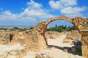
Inside the Paphos Archaeological Park, just north of the old harbor, a pile of broken stones and toppled columns marks where one of Cyprus's most important medieval fortresses once stood. Saranta Kolones, which translates to Forty Columns, served as the main defensive stronghold protecting Paphos during a turbulent period when Arab raids threatened the island. Today, visitors walk among its ruins and discover a fortress that endured multiple rebuilds, witnessed crucial historical events, and met a violent end in one of the worst earthquakes ever to strike Cyprus. Historical Background The fortress was built at the end of the 7th century AD under Byzantine rule. Historical records indicate that Theodore, the brother of Emperor Heraclius I, supervised its construction. At that time, the Arab Caliphate had emerged as a powerful force in the Middle East, and Cyprus found itself in the path of expansion. Arab forces launched raids on the island, making coastal cities particularly vulnerable. Paphos, with its strategic harbor and position on shipping routes, needed strong defenses. The Byzantine builders created a formidable structure. The fortress featured walls three meters thick, substantial enough to resist siege weapons of that era. Four massive corner towers anchored the defenses, with four additional intermediate towers positioned along the connecting walls. A moat surrounded the entire complex, and access was only possible…

Read more
The Island Silhouette and Identity

The Island Silhouette and Identity

The island silhouette on Cyprus's national flag represents one of the few instances worldwide where a nation displays its complete geographical outline on its official symbol. The copper-orange map emphasizes the entirety of Cyprus, deliberately designed to be geographically accurate and represent all Cypriots regardless of cultural or political affiliations. This visual representation connects deeply to national identity, appearing not just on flags but in government documents, tourism materials, commercial packaging, and cultural expressions that define what it means to be Cypriot. The shape itself evokes 9,000 years of continuous habitation, from Neolithic settlements to Bronze Age copper trading empires to modern European Union membership. The positioning of the island closer to the hoist represents aspiration for harmonious coexistence, while the entire design serves as constant visual reminder of territorial integrity and unity despite the 1974 division that created separate de facto zones in north and south. Geographic Recognition and National Unity The silhouette reinforces the idea of unity by representing all Cypriots regardless of their cultural or political affiliations. Unlike flags featuring abstract symbols or historical emblems, the Cyprus map provides concrete geographical reference that citizens from all communities can identify with equally. The deliberate choice to show the complete island rather than symbolically representing only Greek or Turkish Cypriot areas demonstrated commitment to territorial integrity at independence. The…

Read more