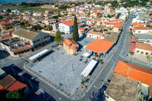
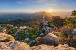
Explore Cyprus with Our Interactive Map

Explore our top stories and discover ideas worth your time.

Panagia Angeloktisti Church

Panagia Angeloktisti Church

Panagia Angeloktisti Church stands in the village of Kiti, roughly 12 kilometers southwest of Larnaca. The church dates to the 11th century and was built over the ruins of a 5th century early Christian basilica. The name Angeloktisti translates to "Built by Angels" in Greek. The original apse of the basilica survived along with one of the finest pieces of Byzantine art on the island, a rare 6th century mosaic of the Virgin Mary and Child between the Archangels Michael and Gabriel. This stone church preserves multiple layers of Cyprus's religious history, from early Christian times through Byzantine and Frankish periods. The building serves as an active place of worship while housing artistic treasures that connect directly to the Byzantine Empire's golden age. Historical Background The residents of ancient Kition moved to Kiti to escape Arab invasions that plagued the coastal areas during the 7th and 8th centuries. Kition was an ancient Phoenician and Greek city-kingdom that served as a major port, exporting agricultural products across the eastern Mediterranean. As Arab raids intensified and the Byzantine Empire struggled to maintain control over Cyprus's periphery, inhabitants sought safer inland locations. Many Cypriot basilicas were destroyed around the 7th and 8th centuries, either from Arab raids or fires, since churches were wooden structures lit by oil lamps. The apse and mosaic at…

Read more
Kyrenia Mountains

Kyrenia Mountains

Whether you stand on the observation deck in Troodos near the summit of Mount Olympus on a clear day, walk across the rolling fields of the Mesaoria plain, or simply drive through the streets of Nicosia, your eyes will inevitably be drawn north. There, a long, jagged ridge cuts across the horizon like a line drawn by a giant hand. In some places it rises so sharply that it feels unreal, as if the land itself has been lifted and frozen mid-motion. At sunrise it glows pale and soft. By midday it hardens into white stone. At dusk it becomes a jagged silhouette, like the ruins of a forgotten kingdom. These are the Kyrenia Mountains, also known as Pentadaktylos. Unlike Troodos, which rises gradually through valleys, plateaus and forests, the Kyrenia Mountains are abrupt, almost theatrical. They form a narrow ridge stretching for almost 200 kilometres, from Cape Kormakitis in the west to Cape Apostolos Andreas in the east. To the north they fall sharply toward the sea, separated by a narrow coastal strip rarely more than five kilometres wide. To the south they rise almost vertically above the flat Mesaoria plain. They look less like mountains and more like a stone wall, or the ruins of a forgotten city from the fantasy epic. And in many ways, they are…

Read more
Cape Greco Sea Cliffs And Caves

Cape Greco Sea Cliffs And Caves

Cape Greco rises from the Mediterranean Sea at Cyprus's southeastern tip, where limestone cliffs drop sharply into turquoise waters, and erosion has carved spectacular sea caves that extend up to 80 metres into solid rock. Cape Greco, also known as Capo Greco or Kavo Greko, forms a rocky peninsula jutting into the Mediterranean between the resort towns of Ayia Napa and Protaras. The headland marks the easternmost point of both the Republic of Cyprus and the European Union, excluding outlying territories. The area covers 385 hectares protected as National Forest Park under the Cyprus Forestry Department since 1993, with additional recognition as part of the Natura 2000 network for its European ecological significance. Historical Background The limestone cliffs at Cape Greco formed from sediments deposited when shallow seas covered the region millions of years ago. Marine organisms including mollusks, corals, and microscopic creatures contributed calcium carbonate that accumulated on the seabed and eventually compressed into rock layers. Tectonic activity lifted these sediments above sea level, creating the elevated plateau that characterizes the cape today. Wave erosion shaped the detailed features that make Cape Greco distinctive. Constant pounding by Mediterranean storms exploits weaknesses in the limestone, gradually hollowing out caves, cutting through narrow points to form arches, and creating vertical channels where waves compress and release with explosive force. This process…

Read more