Cyprus marine waters support diverse habitats that harbor exceptional biodiversity despite increasing environmental pressures. The island’s coastal ecosystems include Posidonia oceanica seagrass meadows, rocky reefs, soft bottom communities, and caves that provide essential services to both marine life and human populations. Recent mapping efforts estimate 10 to 17 square kilometers of seagrass meadows around Cyprus, storing approximately 19,000 metric tons of carbon in their tissues and sediments.
These underwater gardens produce oxygen, support fish nurseries, protect coastlines from erosion, and filter water while sequestering carbon. The European Union classifies Cyprus waters as part of the oligotrophic Levantine Basin, characterized by warm temperatures, high salinity, and low nutrient levels that create unique ecological conditions. Six Natura 2000 sites protect critical marine habitats, though enforcement and active management remain challenging.
- Posidonia oceanica meadows anchor coastal ecosystems
- Marine Protected Areas safeguard critical habitats
- Invasive species threaten native communities
- Carbon storage in blue carbon ecosystems
- Threats from human activities require urgent response
- Conservation efforts build protection networks
- Why marine habitats define Cyprus's future
Posidonia oceanica meadows anchor coastal ecosystems
Posidonia oceanica, commonly called Neptune grass, forms extensive underwater meadows endemic to the Mediterranean Sea. This flowering marine plant consists of roots, rhizomes, and long ribbon like leaves that can extend several meters. The meadows grow on various substrates including sand, silt, and rock at depths from 2 to 20 meters, though they extend much deeper in some locations. Cyprus hosts healthy and widespread Posidonia meadows in nearly all coastal regions, beginning around 2 meters depth.
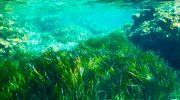
The European Environmental Agency assessment for 2013 to 2018 assigned favorable conservation status to Posidonia sites in Cyprus, Malta, and Slovenia, while sites in France, Greece, Italy, and Spain received inadequate ratings. This exceptional status reflects relatively lower development pressure and effective protection measures. The meadows produce over 5,000 liters of oxygen per square meter annually in daylight, earning their reputation as the lungs of the sea. Each meadow houses countless marine organisms including hundreds of invertebrate species, with studies detecting large quantities of bryozoans living on leaves and rhizomes.
Marine Protected Areas safeguard critical habitats
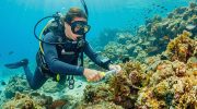
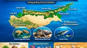
Five coastal Marine Protected Areas established in the Turkish-occupied part of Cyprus since 2009 safeguard critical habitats and species along approximately 134 kilometers of coastline, encompassing around 17,596 hectares of marine environment. This represents about one fifth of the island’s total coastline. The establishment followed extensive research that identified key biodiversity features including Posidonia meadows, rocky reefs, and sandy bottoms that support endangered green and loggerhead sea turtles, Mediterranean monk seals, and various sharks and rays.
A ban on industrial fishing and slower economic growth created opportunities for conservation by inadvertently limiting habitat degradation. However, small scale fisheries increasingly pressure marine ecosystems, reducing populations of marine vertebrates and undermining their ecological roles. Legal measures provide frameworks to reduce fishing pressures in biodiversity hotspots, though enforcement and active management remain in early stages.
Invasive species threaten native communities
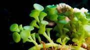
Alien species pose significant threats to Cyprus marine ecosystems, with at least two major invaders documented. The invasive alga Caulerpa racemosa var cylindracea occupies the same habitats as Posidonia meadows and outcompetes the native seagrass for space and resources. This aggressive species spreads rapidly and forms dense mats that smother existing vegetation. The alien gastropod species Conomurex persicus and Cerithium scabridum dominate some barren rock habitats where native species should thrive.
The orange spotted toadfish Torquigener hypselogeneion, another alien, has established populations in Cyprus waters. Studies of the invasive pufferfish Lagocephalus sceleratus found it has diverse diet and thrives in its new habitat, suggesting high potential to adversely impact local biodiversity. These invasions reflect broader Mediterranean patterns where species from the Red Sea enter through the Suez Canal or arrive via ship ballast water, finding favorable conditions in warming eastern Mediterranean waters.
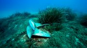
Carbon storage in blue carbon ecosystems
The carbon stored in Posidonia oceanica meadows contributes to climate change mitigation through blue carbon sequestration. Cyprus’s estimated 19,000 metric tons of carbon stored in seagrass tissues and underlying sediments represents significant climate value. Blue carbon refers to carbon captured by ocean and coastal ecosystems, which can store carbon for centuries or millennia when left undisturbed.
The meadows capture atmospheric carbon dioxide through photosynthesis and transfer it to long lived plant tissues and sediment deposits. When seagrass meadows are destroyed through coastal development, trawling, or pollution, this stored carbon releases back to the atmosphere as greenhouse gases.
Conservation of existing meadows and restoration of degraded areas therefore provides climate benefits alongside biodiversity protection. The European Union’s Marine Strategy Framework Directive incorporates Posidonia monitoring programs, while the Water Framework Directive uses the species as a biological quality indicator for assessing ecological status of water bodies.
Threats from human activities require urgent response
Cyprus marine habitats face multiple human pressures that degrade ecosystem health. Coastal development destroys habitats directly through construction while increasing runoff of sediments and pollutants. Desalination plants create hypersaline outfalls that stress nearby Posidonia meadows, with major facilities operating at Larnaca and Dhekelia.
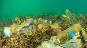
Bad anchoring practices damage seagrass when boats drop anchors directly onto meadows, tearing up plants and creating scars that take decades to heal. Fishing equipment that drags along the bottom causes extensive harm to both Posidonia meadows and the marine life within.
Industrial and agricultural pollution introduces nutrients that can trigger algal blooms, while heavy metals and chemicals accumulate in sediments and tissues. Climate change raises water temperatures and increases storm intensity, stressing species adapted to historical conditions. Deep sea habitats below 200 meters remain totally unstudied due to lack of resources and infrastructure, though they likely remain undisturbed since no trawling occurs at those depths.
Conservation efforts build protection networks
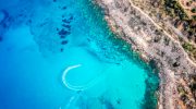
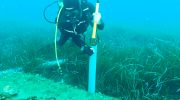
Cyprus initiated its first national effort to map marine ecosystems around the entire government controlled coastline through a project running from 2019 to 2022. This multidisciplinary initiative developed high resolution cartography for Posidonia oceanica meadows and other important habitats under the European Habitats Directive. The project also marked the first study of underwater caves.
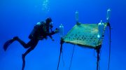
Researchers employed satellite imagery from Sentinel-2 combined with machine learning classifiers and Google Earth Engine cloud computing to create accurate habitat maps. The workflow achieved 73.5 percent overall accuracy, demonstrating that remote sensing technology can support conservation when combined with field campaigns.
The approach maximizes benefits of satellite data while complementing in situ measurements, leading to more effective scientific research and decision making. The methodology proves scalable across the Eastern Mediterranean region, providing a replicable model for countries lacking comprehensive marine habitat data.
Why marine habitats define Cyprus’s future
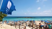
Cyprus marine ecosystems provide the foundation for tourism, fisheries, and coastal protection that sustain island economy and quality of life. The favorable conservation status of Posidonia meadows distinguishes Cyprus from neighboring countries where seagrass has declined dramatically. Maintaining this advantage requires continued investment in protection, monitoring, and enforcement. The carbon storage provided by seagrass meadows contributes to national climate commitments under international agreements.
The biodiversity supported by healthy marine habitats attracts diving tourism and supports commercial and recreational fisheries. Coastal protection from seagrass meadows reduces erosion and storm damage, protecting infrastructure and beaches. For Cyprus, marine habitat conservation represents not just environmental responsibility but economic necessity, as degraded ecosystems would undermine the tourism sector and reduce resilience to climate change impacts.