While climbing the high slopes of Troodos we’ve been walking on the frozen machinery of an ancient ocean. But now it’s time to step away from the mountain, slightly change our story and observe what had been happening under the sea, as the Olympus peak was rising into the sky.
Leaving the cool shade of Platres behind, we approach the wine village of Omodos. The dark volcanic surfaces give way to pale rocks. Chalk breaks easily under your fingers. Hills become rounder. Valleys widen. Vineyards, orchards and white stone villages appear. The geology has shifted from fire to sediment.
Encircling the Troodos massif lies a vast geological belt known as the Circum-Troodos Sedimentary Succession. It is the quiet counterpart to the violent ophiolite core. While Troodos itself formed through submarine volcanism deep beneath the Neo-Tethys Ocean, these surrounding rocks were created slowly, grain by grain, as sediments settled on the seabed around the rising mountains.
For nearly eighty million years, currents carried shells, clay, volcanic fragments and microscopic marine organisms into the surrounding basin. Layer upon layer accumulated. Over time these sediments hardened into limestones, chalks, marls and sandstones that now form the foothills surrounding the Troodos range.
If the ophiolite tells the story of the ocean floor, the Circum-Troodos formations tell the story of the island emerging from that ocean.
These rocks record a long transition. Deep marine conditions gradually became shallower seas, then coastal environments and finally landscapes where rivers cut valleys and people built villages.
1. The Oldest Sediments: The Kannaviou Group
The earliest part of the Circum-Troodos sequence formed during the Late Cretaceous period, roughly seventy to eighty million years ago. At that time Troodos had only recently begun to rise from the ocean floor. Around it stretched a deep marine basin where sediments accumulated along the edges of the emerging ophiolite.
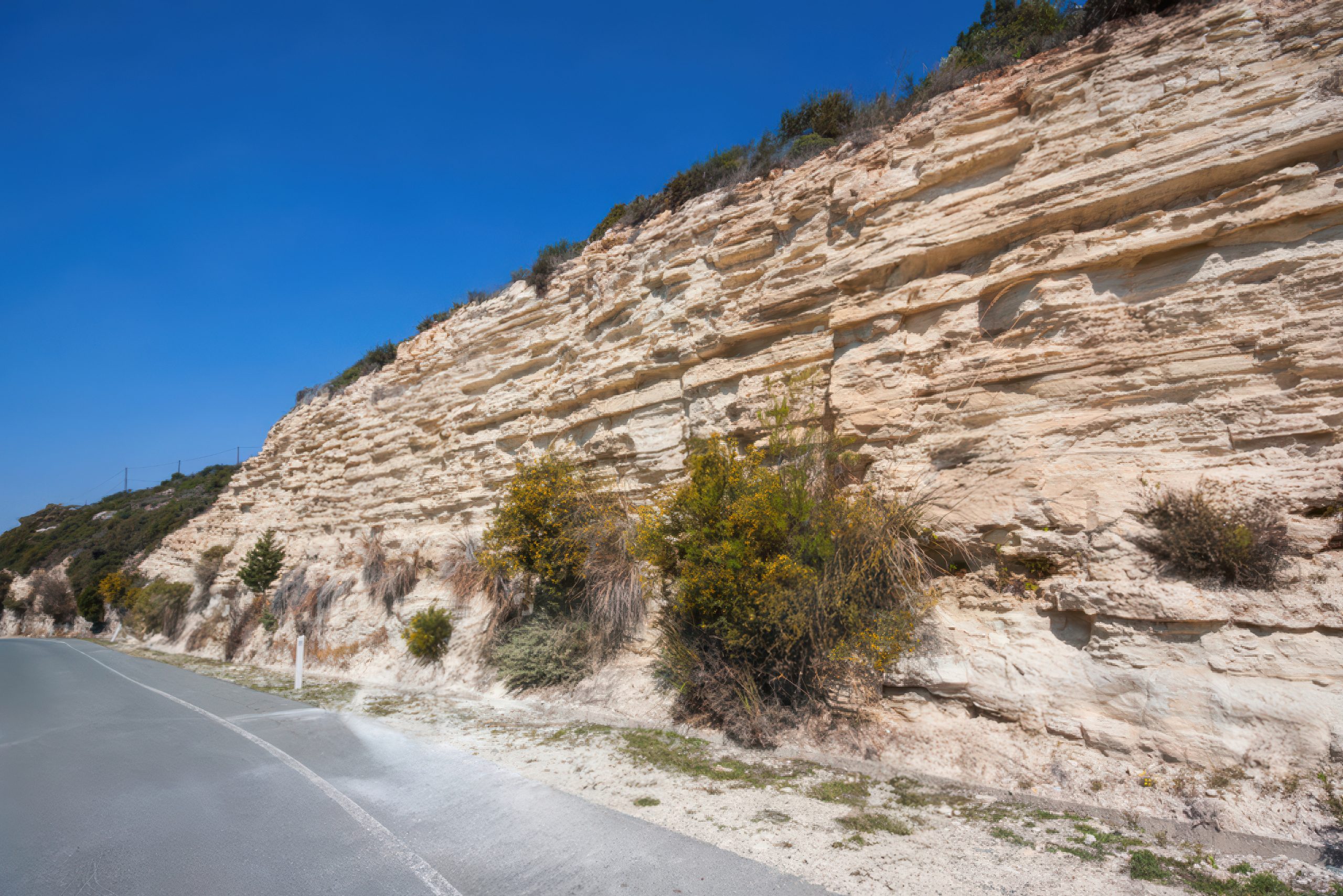
One of the oldest of these formations is known as the Kannaviou Group. These rocks appear mostly in western Cyprus, particularly in the transition zone between the Mamonia Complex and the outer volcanic slopes of Troodos. They consist mainly of layered limestones and sandstones, often appearing in thick beds stacked one above another.
The limestones are pale grey to creamy white, sometimes weathering into honey-coloured tones. The sandstones tend to be darker and grainier, formed from fragments eroded from nearby volcanic rocks.
These sediments were originally deposited on the floor of the ancient sea surrounding the rising Troodos massif. Currents transported material from both the ophiolite slopes and the continental margin. As a result, the formation records a mixture of sources, reflecting the complex geological environment of the time.
The landscapes formed by the Kannaviou Group tend to be rugged yet fertile. Rivers have carved deep valleys into the layered rock, exposing clear cross-sections where the sedimentary layers can be observed almost like pages in a geological archive.
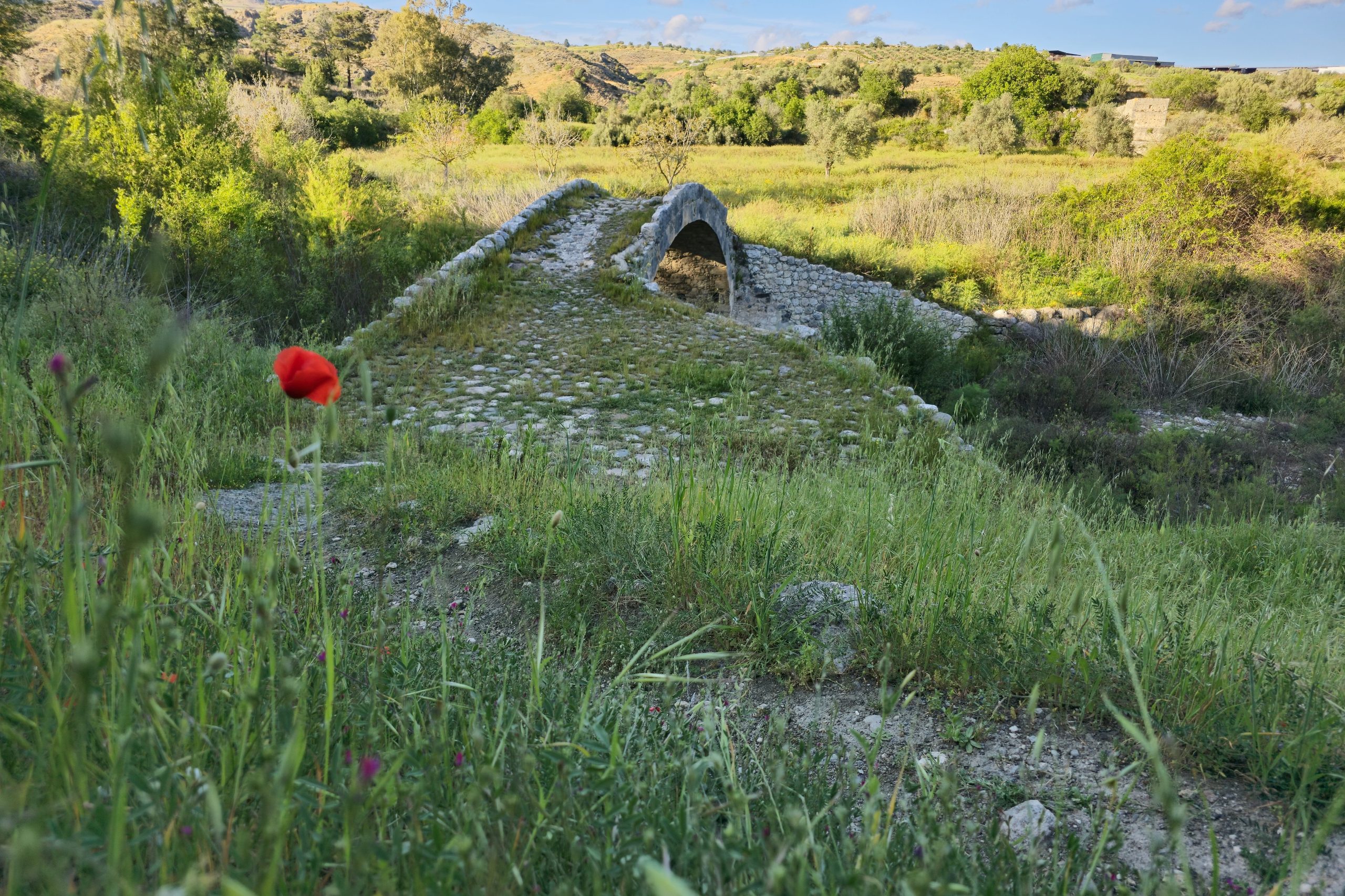
One of the best examples lies along the Stavros tis Psokkas River valley, between the villages of Lysos and Fyti. Here the river has cut deeply through the formation, revealing dramatic cliffs of layered limestone and sandstone. The picturesque Skarfos Bridge, built during the Venetian period from the very same local stone, arches gracefully across the river here. Its pale blocks blend almost seamlessly with the surrounding cliffs, as if the bridge had grown out of the landscape itself. Walking through this valley feels like stepping into one of the earliest chapters of Cyprus’s geological story, where ancient marine sediments quietly reveal the beginnings of the island.
Where to see it?
- Stavros tis Psokkas River valley between the villages of Lysos and Fyti.
2. The Para Pedi Formation: Dark Minerals from the Ancient Sea
Another formation dating from the late Cretaceous period occurs near the mountain village of Para Pedi, whose name it carries.
At first glance the Para Pedi Formation appears less spectacular and much smaller than the volcanic rocks of Troodos or the white cliffs of later formations. Yet it contains some of the most intriguing and rare minerals in the Circum-Troodos sequence.
Among them are umber and chert. Umber is a dark brown or reddish rock rich in iron and manganese oxides. Historically it was ground into pigment and used as a natural colourant in paints. In geological terms umber forms through slow chemical precipitation on the ocean floor, often associated with hydrothermal activity linked to volcanic environments.
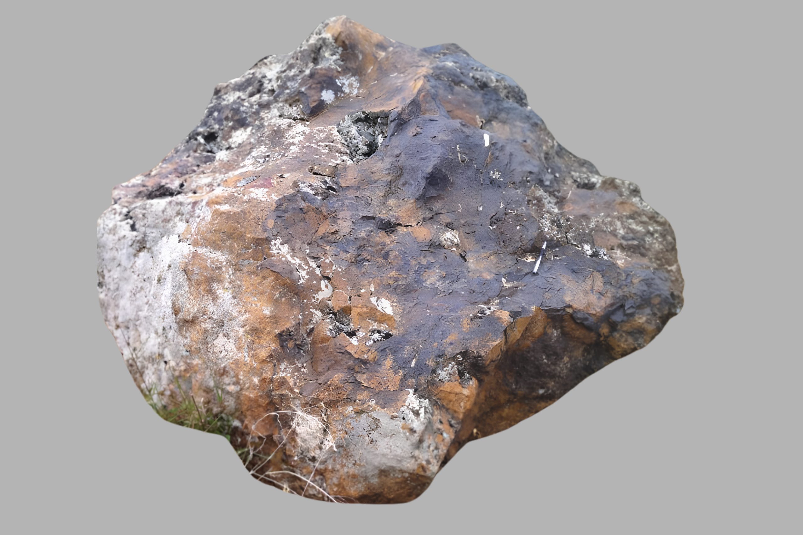
Chert, by contrast, is a hard silica-rich rock that often appears in shades of grey, brown or black. It forms from microscopic marine organisms whose silica skeletons accumulate on the seabed. Over time the material compacts and hardens into dense nodules or layers.
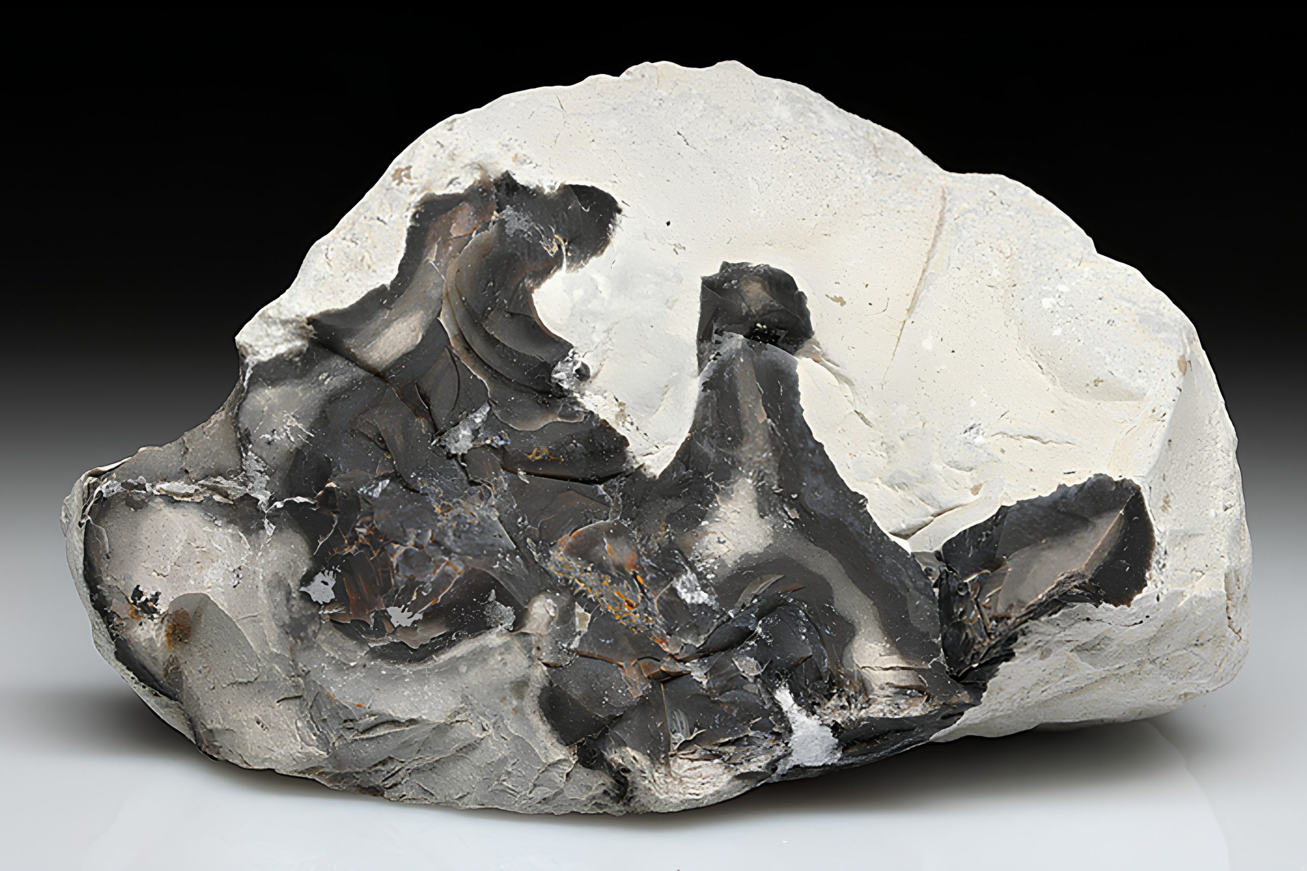
These two rocks give the Para Pedi formation a distinctive appearance. Dark, almost metallic bands of umber contrast with the smooth, glassy surfaces of chert. When sunlight strikes freshly exposed surfaces the rocks can appear almost polished.
Together they represent sediments deposited in deep marine conditions while Troodos was still emerging from the ocean.
Where to see it?
- Along the old road between Para Pedi and Platres, where exposures of umber and chert appear in road cuts.
3. Lefkara Formation: The Classic White Stone of Cyprus
If the older Cretaceous formations record deep marine environments, the Lefkara Formation marks a later stage in the island’s geological evolution.
Dating from the Paleogene period, this formation consists mainly of chalks and marls, soft white rocks rich in calcium carbonate. They were formed from the accumulation of microscopic marine organisms whose shells slowly settled on the seabed over millions of years.
The result is a landscape dominated by pale stone. The hills appear almost bleached and luminous under the Mediterranean sun, particularly during dry summer months when vegetation is sparse. The name Lefkara itself reflects this geology. In Greek the word “lefko” means “white”, referring to the bright colour of the stone. Thus, the famous traditional village of Lefkara takes its title from these chalk deposits.
Because the rock is relatively soft and easy to shape, it became a favourite building material throughout Cyprus. Many traditional villages were constructed using this pale limestone, giving them their characteristic light appearance.
The Lefkara Formation also plays an important role in the island’s modern economy. Its calcium-rich chalk is one of the primary sources of lime used in cement production. Geographically the formation appears widely across the eastern foothills of Troodos and at higher elevations in the west and south of the island.
Where to see it?
- Massive chalk cliffs near Agia Mavri
- Along the road between Skarinou and Lefkara
- The White Cliffs of Agios Georgios near Limassol, where the formation meets the sea
4. Pachna Formation: The Agricultural Heartland
One of the youngest and most economically important geological features in the Circum-Troodos sequence is the Pachna Formation, dating from the Neogene period.

These rocks consist mainly of yellowish chalks and marls, slightly richer in clay than the older Lefkara deposits. Their colour often ranges from pale cream to warm golden tones.
Geographically the formation spreads across much of southern and south-western Cyprus, forming a broad trapezium whose approximate corners lie at Kouklia, Agios Nikolaos, Lania and Moutagiaka.
The landscapes formed by the Pachna Formation are particularly distinctive. Broad fertile plateaus alternate with deep river gorges carved by seasonal streams. The soils derived from these rocks are rich in calcium and minerals, creating ideal conditions for agriculture. This region forms one of the most productive rural zones of Cyprus.
Ancient carob groves grow around Anogyra, where the trees have long been part of the island’s agricultural tradition. Olive orchards cover many of the hills. Near Limnatis extensive almond plantations bloom spectacularly in late winter and early spring.
Perhaps most famously, the Pachna Formation forms the geological foundation of two historic wine regions: Krasohoria Lemesou (cantered around Omodos) and Commandaria (slightly to the East).
Nearly half of Cyprus’s wineries lie within this geological zone. The mineral composition of the soils and the gently elevated terrain create a distinctive terroir that has supported viticulture for centuries.
Livestock farming also thrives here. The rolling hills between Avdimou and Pachna are widely used for goat and sheep grazing, producing milk that becomes one of Cyprus’s most iconic foods: halloumi.
Where to see it?
- Throughout the foothills between Limassol and Paphos
- Road cuts along the A6 Limassol-Paphos highway near Paramali and Sotira
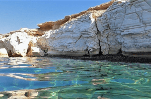
5. Dramatic Coastal Landscapes
Where the Circum-Troodos formations reach the sea, they create some of the most spectacular coastal landscapes in Cyprus.
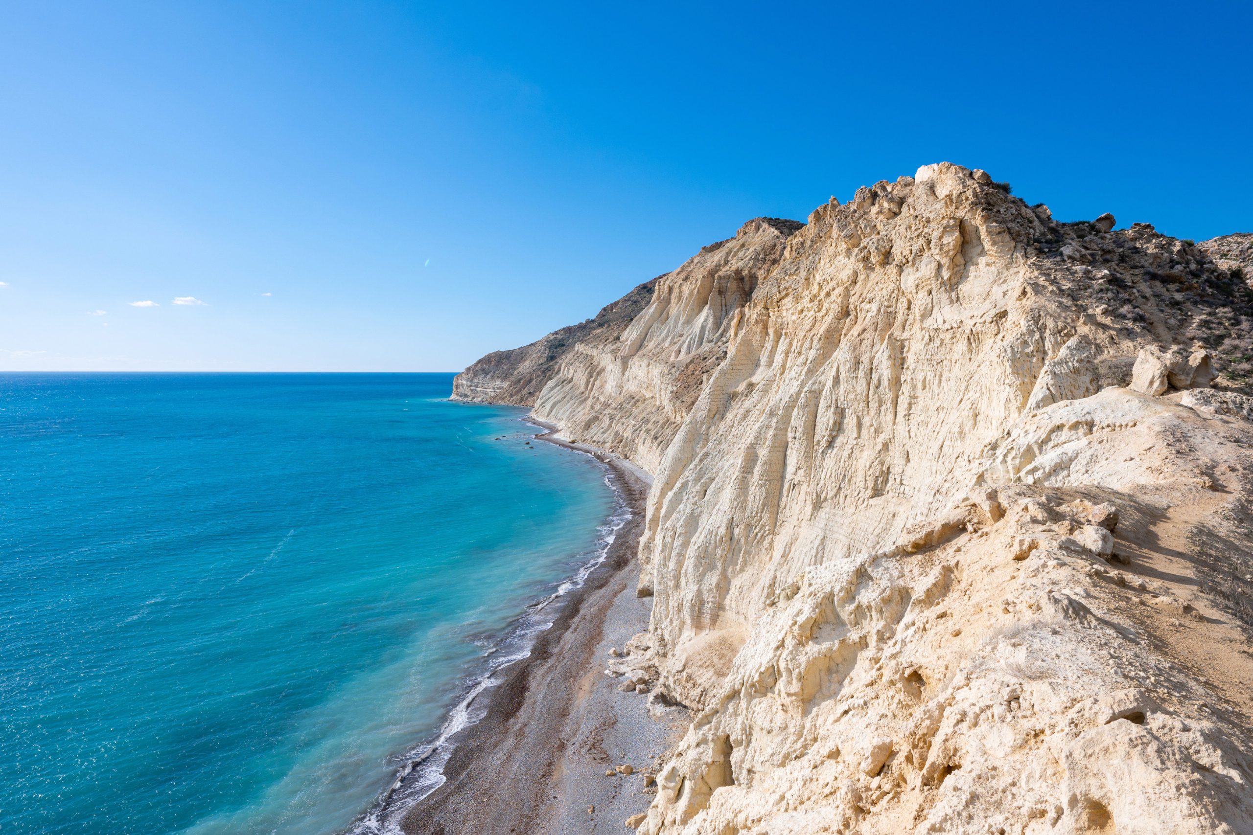
Perhaps the most impressive are the White Cliffs of Pissouri, stretching along the coastline near Cape Aspro. These towering chalk giants rise more than 300 metres above the Mediterranean, forming the highest coastal drops on the island. Their almost vertical slopes appear dazzlingly bright in sunlight, contrasting sharply with the deep blue sea below.
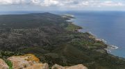
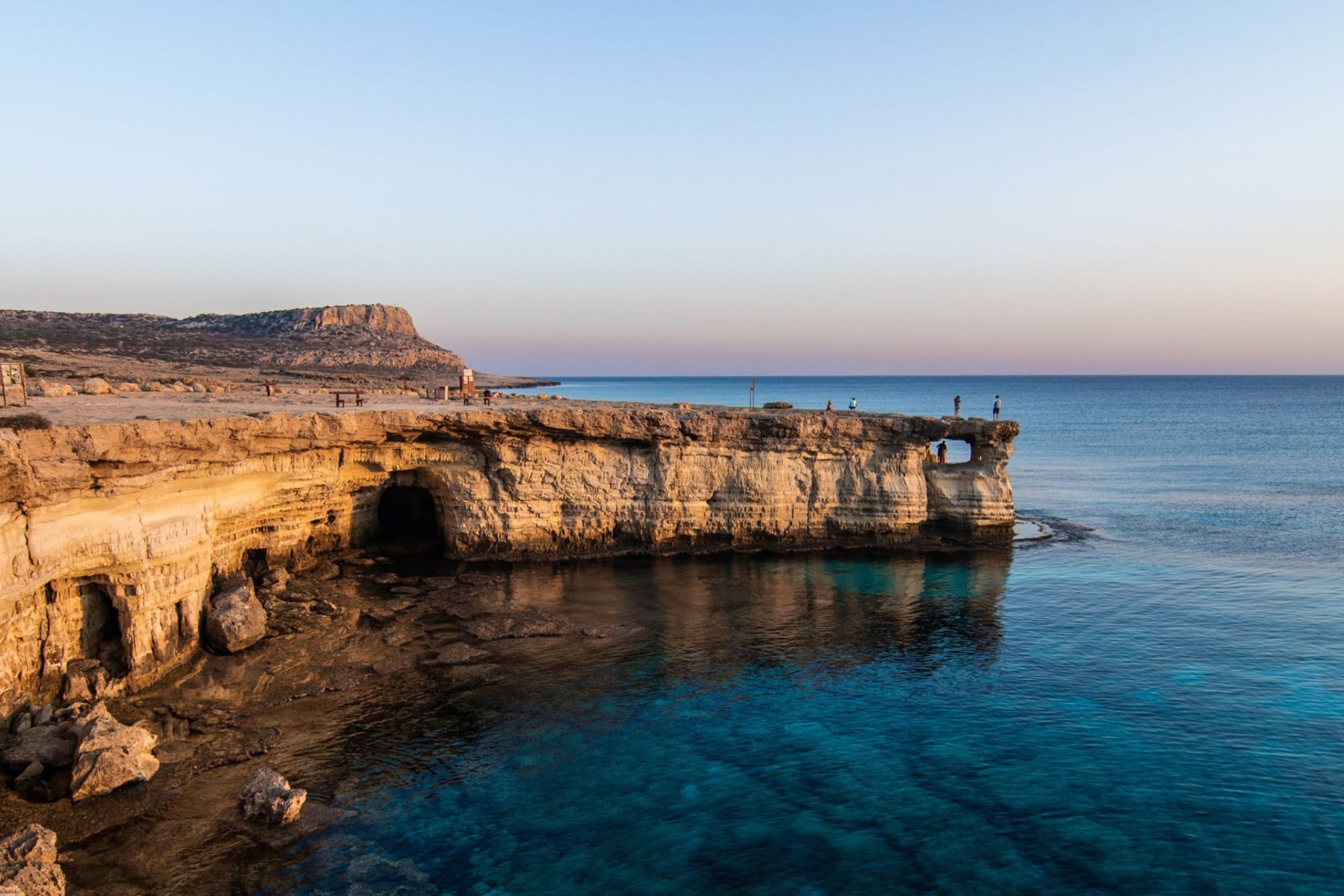
Another remarkable coastal landscape lies at Cape Greco National Park between Ayia Napa and Protaras. Here the sedimentary rocks form ancient reef structures had been shaped by intense marine erosion. Wind and waves have carved the limestone into arches, sea caves and jagged rock formations both above and below the waterline. The result is a coastline that looks almost sculpted by nature.
6. Conclusion
While Troodos reveals the fiery birth of Cyprus from the depths of the ocean, the Circum-Troodos sediments tell the slower story that followed.
Layer by layer these rocks record how the island rose from the sea, how ancient marine basins became shallow waters, and how eventually landscapes suitable for agriculture and settlements emerged.
Today these formations support vineyards, orchards, grazing lands and villages that depend on the fertile soils created from marine sediments millions of years old.
In this sense the Circum-Troodos belt is the quiet architect of much of Cyprus’s countryside.
The mountain tells us how the island was born. The surrounding sediments show how it learned to live.