Cyprus isn’t just sitting on the Mediterranean – it’s rising from deep inside the Earth itself. The island’s mountains, plains, and dramatic coastlines tell a story millions of years in the making, a story written by colliding continents, ancient oceans, and forces powerful enough to lift the ocean floor into the sky. Understanding Cyprus’s geography means understanding why civilizations flourished here, why copper made the island famous, and why the landscape itself feels almost mythical.
An Island Shaped by Deep Forces
Cyprus stands where Europe, Asia, and Africa nearly touch, and this position at the crossroads of three continents isn’t just cultural – it’s geological. The island’s dramatic landscape reflects its location along active tectonic boundaries where massive plates of Earth’s crust push, pull, and collide. This created an island unlike almost anywhere else on Earth, with features that have fascinated geologists, attracted ancient miners, and shaped human history for thousands of years.
The island is defined by contrasts: dark volcanic mountains in the south, pale limestone ridges in the north, and a flat plain stretched between them. Rocky headlands meet sandy beaches, mountain forests give way to sun-baked lowlands, and seasonal rivers carve valleys that run dry under the summer sun. This geographic diversity packed into one relatively small island created the conditions for civilization to take root and thrive.
When Ancient Oceans Became Mountains
Millions of years ago, Cyprus didn’t exist. The area was covered by the Tethys Sea, an ancient ocean that separated Africa from Eurasia. As tectonic plates shifted over geological time, something extraordinary happened: sections of the ocean floor were pushed upward and exposed above sea level, forming what would become the Troodos Mountains.
This rare process lifted rocks from deep within the Earth – including pieces of the planet’s mantle – into the open air. Later tectonic movements folded and raised marine limestone deposits into the Kyrenia Mountains (also called Pentadaktylos). Between these two mountain ranges, sediments carried by rivers accumulated over thousands of years to create the Mesaoria Plain.
By the time humans arrived over 11,000 years ago, Cyprus already had mountains rich in copper and other minerals, fertile lowlands perfect for farming, and a long coastline full of natural harbors. These features weren’t random – they were the direct result of the island’s violent geological birth. The geology of Cyprus didn’t merely form the island; it created the conditions for civilization to develop upon it.
A Landscape of Three Parts
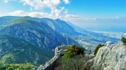
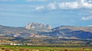
Cyprus has a distinctive “mountains – plain – mountains” structure that dominates the island’s geography and has shaped human settlement patterns for millennia. The Troodos Mountains rise in the southwest, dark and rugged, their volcanic origins still visible in the rock. The Kyrenia Mountains stretch along the northern coast as a narrow, dramatic limestone ridge with sharp peaks and steep cliffs. Between them lies the Mesaoria Plain, flat and dry, built from sediments washed down from both ranges by seasonal rivers.
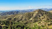
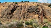
The Troodos range is the island’s geological heart, containing ancient lava flows, basalt, and mineral-rich zones including copper, chromite, and iron. Ancient Cypriots mined these metals extensively, and Cyprus became famous for copper throughout the ancient world – so famous that the island’s name may be the origin of the English word “copper” itself. These mountains also trap moisture from passing clouds, making them cooler and wetter than the lowlands. Forests, vineyards, and terraced villages cover their slopes.
The Kyrenia Mountains tell a different geological story. Formed from ancient marine sediments that were folded and uplifted by immense tectonic pressure, their pale limestone cliffs and jagged ridges reflect intense geological compression. The most famous peak, Pentadaktylos (“Five Fingers”), dominates the northern skyline and appears in local legends about saints and giants. These mountains form a natural barrier between the coast and the interior, influencing weather patterns, travel routes, and defensive settlement strategies throughout history.
The Mesaoria Plain is Cyprus’s agricultural heartland, growing wheat, barley, and olives since prehistoric times. But low rainfall and poor drainage make it prone to drought, erosion, and soil salinization – challenges that remain critical today. This flat corridor became the main route for travel and trade, connecting the island’s different regions and city-kingdoms.
Cyprus has no permanent rivers – only short seasonal streams that flow after winter rains and disappear completely in summer. This scarcity of water has shaped both ancient and modern settlement patterns, making springs and wells precious resources worth fighting over.
Remarkable Geological Features
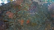
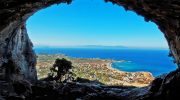
- Walkable Ocean Floor – What makes Cyprus truly unique geologically is that it exposes deep Earth layers at the surface. The Troodos Ophiolite Complex is one of the most studied geological formations on Earth, allowing scientists to examine ancient ocean crust and mantle rock without drilling beneath the sea. Few places on the planet let humans literally walk on what was once the ocean floor.
- Mountains Named After Fingers – The Kyrenia range’s highest peak, Pentadaktylos, got its name (“Five Fingers”) from its distinctive shape when viewed from certain angles. Local legends claim a giant or saint left handprints in the mountain, giving the stark limestone ridge a mythical quality.
- Copper That Named an Island – Cyprus’s copper deposits were so famous in antiquity that the island’s ancient name, Kypros, became the Latin “cuprum” – the direct source of the English word “copper.” The metal connected Cyprus to Egypt, Greece, and the Near East, making the island wealthy and strategically important.
- Earthquakes as Time Capsules – Active fault zones beneath Cyprus have triggered devastating earthquakes throughout history, destroying cities like Kourion and Salamis. But these disasters also preserved moments in time, with collapsed buildings freezing daily life beneath them like ancient snapshots.
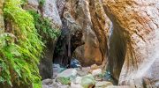
- Limestone Cliffs That Were Coral Reefs – The dramatic sea cliffs at Akrotiri Peninsula and elsewhere were once living coral reefs growing underwater. Tectonic uplift raised them above sea level, and waves have since carved them into caves, arches, and dramatic formations that reveal the island’s marine past.
- Springs Believed Divine – Mineral-rich springs emerge where groundwater meets volcanic rock in Troodos, producing waters containing iron, sulfur, and trace metals. In antiquity, these springs were believed to heal illness and were associated with divine favor. Villages formed around them, and some remain in use today.
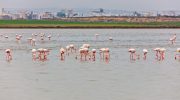
- Flamingos on Salt Lakes – Larnaca and Akrotiri contain salt lakes formed by flat basins and evaporation. Historically mined for salt, these lakes now serve as winter habitats for flamingos and other migratory birds, creating surreal pink flocks against the Mediterranean landscape.
How Rock Types Shaped Culture
Different rock types across Cyprus produce different soils, and these soils determined what people could grow and where they chose to settle. Volcanic soils in Troodos support the island’s famous vineyards, producing wines with distinctive mineral characteristics. Limestone soils support olive trees and hardy shrubs. Alluvial soils in the Mesaoria Plain support grain farming. These geological differences translated directly into cultural and economic specialization across the island.
Much of Cyprus’s limestone terrain contains karst landscapes – areas riddled with caves, sinkholes, and underground drainage systems. These features control groundwater storage and spring locations, and ancient Cypriots often used caves as shelters or sacred spaces. The Akamas Peninsula, one of Cyprus’s most geologically varied regions, contains volcanic rock, limestone, and karst formations shaped by erosion, creating a wild landscape that myth linked to Aphrodite and Adonis.
Geology even shaped religion and mythology. Mountains were considered sacred, caves became holy sites, and springs were seen as divine gifts. Aphrodite’s mythical birthplace at Petra tou Romiou is tied to dramatic sea cliffs and rock formations near Paphos, where geology and mythology became inseparable. The landscape itself became proof of the myths, with natural features serving as evidence that gods had walked there.
Human activity has continuously modified Cyprus’s geology through ancient copper mining, quarrying, dam construction, urban expansion, and coastal development. The scars of ancient mining operations are still visible in Troodos, and massive stone quarries supplied building material for temples and cities across the Mediterranean world.
A Living Landscape Today
Modern Cyprus still depends fundamentally on its geography. The Troodos Mountains provide a cooler climate that makes them popular for summer tourism and winter skiing. The Mesaoria Plain continues to feed the island, though now with the help of dams and irrigation systems. The varied coastline drives tourism, with different beaches and cliffs offering diverse experiences.
Active fault zones influence modern building codes, and geologists monitor seismic activity to protect cities. Water scarcity – a direct result of Cyprus’s seasonal rivers and limited rainfall – has led to desalination plants and extensive dam construction to capture and store winter rains.
The Troodos Mountains are now a UNESCO Global Geopark, recognized for their international geological importance. Schools teach Cyprus’s unique geology as part of national identity, and museums and geological parks celebrate the island’s role in understanding how Earth works. For Cypriots, their landscape isn’t just scenery – it’s a source of pride and a fundamental part of who they are.
Some plants grow only on Troodos’s metal-rich volcanic soils, having evolved to tolerate copper and chromite that would poison most vegetation. These endemic species make Cyprus important for botanical research and biodiversity conservation.
Experiencing Cyprus’s Geological Story
- Troodos Mountains – Hike trails that cross ancient ocean crust and volcanic rock. The landscape changes dramatically as the visitor climbs, from Mediterranean scrub to pine forests to bare rock near the peaks. Standing on these mountains means standing on what was once the ocean floor, pushed up by forces deep within the Earth.
- Kyrenia Range – Walk the ridgelines and enjoy dramatic views of limestone cliffs dropping toward the sea. The rock formations show clear evidence of folding and compression from tectonic forces. Medieval castles perched on these peaks demonstrate how geography influenced military strategy for centuries.
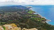
- Akamas Peninsula – Explore one of Cyprus’s wildest areas, where volcanic rock meets limestone and erosion has carved dramatic coastal features. Limited development has preserved rare plant species and wildlife, offering a glimpse of what much of Cyprus once looked like.
- Salt Lakes at Larnaca and Akrotiri – Visit during winter migration to see thousands of flamingos turning the shallow waters pink. These flat basins demonstrate how evaporation in Cyprus’s hot climate creates unique ecosystems.
- Akrotiri Sea Caves – Walk along cliffs where waves have carved caves and arches into uplifted limestone. Marine fossils visible in the rock prove these cliffs were once underwater coral reefs.
- Troodos Geopark – Follow marked geological trails that explain the island’s formation. Information panels describe how ocean crust, volcanic activity, and tectonic uplift created the landscape. The experience makes complex geology accessible and fascinating.
Why Cyprus’s Landscape Matters
Cyprus is a rare place where Earth’s deep past is visible at the surface – where people can touch rocks that formed at the bottom of a vanished ocean, walk on ancient lava flows, and see limestone that was once a living coral reef. These geological forces shaped where people lived, what they mined, how they built civilizations, and even what gods they worshipped.
The island’s position at the meeting point of three continents made it geologically dramatic and culturally important. The same tectonic forces that created its diverse landscape also made it a crossroads for trade, ideas, and empires. Geography and history are inseparable here.
Today, Cyprus’s geology remains alive and influential – guiding agriculture, tourism, water management, and national identity. The island isn’t just a Mediterranean destination but a living geological story, where the foundations of the planet can be walked, studied, and experienced by anyone curious enough to look beneath the surface.