Almyras mudstone is a clay-rich badlands landscape in central Cyprus where ancient marine sediments, lifted from the Tethys Ocean, are exposed in sharply eroded hills and gullies. Its colours, microfossils, and altered volcanic ash make the area one of the island’s clearest geological records, and the same clays later supported early copper-smelting activity at Agia Varvara–Almyras.
This article explains how Almyras formed, what the terrain reveals, and how people learned to use the land’s materials for industry.
Quick essentials (for skimmers)
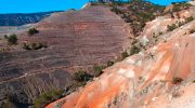
Image Credit: like.philenews.com
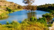
Where: Central Cyprus, mainly around Agia Varvara–Almyras, south of Nicosia
What it is: Marine mudstones and clay formations shaped into badlands
Why it matters: Records Cyprus’s emergence from the sea and supports early metallurgy
Best time to visit: Autumn to spring, after rain but not during storms
What to expect: Fragile terrain, strong visual contrasts, limited formal facilities
Why “Almyras” Means Brackish
The word Almyras comes from the Greek term for “salty” or “brackish.” Across Cyprus, it is used for places where mineral salts influence soil and water. In geology, the name became attached to clay-rich zones where marine sediments, salts, and evaporitic minerals shaped both the land and groundwater.
The most important site carrying this name is Agia Varvara–Almyras, a small hill within the Gialias River basin. While the term appears elsewhere in Cyprus, this inland location became central to archaeological and geological research because it preserves both the formations themselves and clear evidence of how people once exploited them.
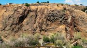
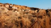
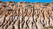
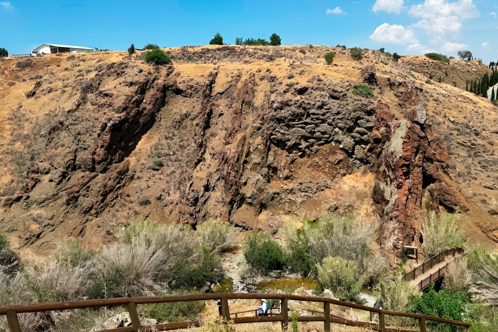
Badlands Carved by Seasonal Rain
Almyras is a classic badlands landscape. These forms are found in areas where soft, clay-rich rocks are exposed to seasonal rain and long dry periods. Water cannot soak easily into the clay, so rainfall rushes over the surface, carving narrow channels that grow deeper each year.
Walking through the area, several features stand out:
- Narrow gullies slicing through slopes like veins
- Fluted ridges etched by runoff
- Clay surfaces that crack into polygon patterns during summer
- Stepped terraces where harder mudstone layers resist erosion
 landscapes-revealed
The terrain changes quickly after rain. Slopes soften, colours deepen, and erosion patterns become sharply defined. In dry weather, the same surfaces harden and fracture, giving the land its distinctive “broken” texture.
Colour Bands That Explain the Past
The colours of Almyras are not random. They reflect chemistry locked into the sediments millions of years ago.
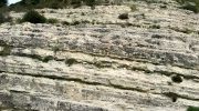
Grey and beige tones point to calcium-rich marine muds formed from microscopic sea life. Reds and ochres signal iron-rich sediments that settled in deeper or low-oxygen waters. Bluish or greenish clays often indicate altered volcanic ash, transformed underwater into swelling clays.
These colour bands are visible clues that Almyras was once part of the ocean floor, layered slowly as fine particles settled through calm water.
When Cyprus Was Still Underwater
The Almyras mudstones formed during a time when Cyprus lay entirely beneath the ancient Tethys Ocean. Fine clay particles, volcanic ash, and microscopic organisms drifted down through quiet waters, settling slowly on the seabed and accumulating in thin, even layers over millions of years.
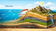
This long period of calm deposition was later disrupted by powerful tectonic forces. As the Troodos oceanic crust rose, these once-submerged sediments were lifted above sea level, exposed to air for the first time. From that moment onward, erosion took over. Rain, wind, and gravity began stripping away softer layers, carving the fragile surfaces that now define Almyras and exposing the island’s transition from deep ocean to dry land with unusual clarity.
Fossils, Ash, and Salt Signals
The marine origin of Almyras is not inferred. It is recorded directly in the rock itself.
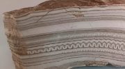
Microscopic fossils such as foraminifera and radiolarians confirm that these sediments formed in deep marine conditions. Thin, rhythmic layering shows slow, uninterrupted deposition, while bentonitic clays reveal volcanic ash altered only in underwater environments. Nearby gypsum and evaporite layers preserve evidence of periods when the Mediterranean partially dried, concentrating salts and minerals.
Taken together, these features turn Almyras into a readable geological archive, where ancient seas are recorded in material form rather than theory.
A Smelting Site Built into Clay
What sets Agia Varvara–Almyras apart is not only its geological clarity, but how early Cypriots learned to work with it. Archaeological excavations revealed a complete Iron Age copper-smelting complex built directly into the mudstone terrain.
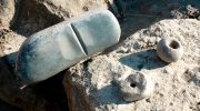
Metalworkers gathered copper ore from nearby oxidised zones, constructed furnaces from local Almyras clay mixed with crushed mudstone, and used iron-rich sediments as flux to regulate smelting temperatures. None of this was accidental. The clay’s mineral structure allowed it to withstand extreme heat without cracking, making it ideal for furnace linings.
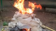
In this way, geology became technology. The properties of the land itself shaped industrial knowledge and helped Cyprus emerge as a major copper producer in the ancient Mediterranean.
Geology Turned into Technologyori
Despite its hardened appearance, Almyras is extremely delicate. The thin surface crust that slows erosion can be broken easily underfoot. After rainfall, slopes soften, hidden cavities form, and the ground becomes unstable.

Visitors are encouraged to stay on existing tracks, avoid slopes after heavy rain, and never remove rock, slag, or clay fragments. The landscape survives best when it is read and observed, not physically tested.
What Almyras Adds to Cyprus
Almyras is not dramatic in the postcard sense, but it is one of Cyprus’s most revealing landscapes. It shows how the island rose from the sea, how erosion reshaped it, and how early communities learned to recognise and use what the land offered.
Where beaches reflect Cyprus’s relationship with leisure, Almyras reflects its relationship with survival, industry, and knowledge. The same quiet clays that once lay on the ocean floor later lined furnaces that powered an ancient economy. That continuity is why Almyras deserves attention, not as an empty badland, but as a place where Cyprus’s deeper story remains clearly written into the ground.