British-built roads, bridges, and public works that transformed mobility, trade, and communication across the island. Colonial Road and Infrastructure Networks in Cyprus mark a pivotal era of transformation under British rule from 1878 to 1960, where engineered roads, bridges, and public works revolutionized the island’s connectivity, boosting trade, communication, and economic integration. These projects, spearheaded by the colonial administration, shifted Cyprus from Ottoman-era isolation to a modernized network, linking remote villages to urban centers like Nicosia, Limassol, and Famagusta.
Key features included macadamized roads, stone bridges (including the Trimiklini Double Bridge) over seasonal rivers, and irrigation dams that supported agriculture, reflecting imperial strategies to exploit resources while imposing control. As symbols of progress and domination, they facilitated troop movements and commerce but also sparked local resistance, highlighting tensions between development and exploitation. Today, many endure as vital arteries, preserved for heritage while adapting to contemporary needs, underscoring Cyprus’s journey from colony to independent nation amid ongoing debates on legacy and sustainability.
- A Transformative Colonial Network
- The Historical Formation and Evolution
- Features of Roads, Bridges, and Public Works
- Notable Aspects That Highlight Its Uniqueness
- Deeper Impacts for Society
- Colonial Road and Infrastructure Networks in Cyprus Today
- Exploring Colonial Routes Today
- A Network of Colonial Transformation
A Transformative Colonial Network
Colonial road and infrastructure networks reshaped Cyprus’s landscape, creating a web of paved routes, sturdy bridges, and essential public works that connected its rugged terrain, from the Troodos Mountains to coastal plains. Spanning thousands of kilometers by independence, the system included major arteries like the Nicosia-Limassol road and rural links to villages, built to withstand the island’s semi-arid climate with annual rainfall around 400mm and seismic activity. Bridges, such as those over the Pedieos River, featured arched stone designs for flood resistance, while dams like Germasogeia irrigated farmlands, enhancing trade in crops like citrus and olives. These projects employed local labor under British engineers, fostering skills but often under exploitative conditions. The networks boosted mobility for merchants, officials, and troops, reducing travel times from days to hours, and improved communication via telegraph lines along roads. In a divided society of Greek and Turkish Cypriots, they symbolized unity under empire but also enabled surveillance, with police stations at key junctions. This infrastructure covered about 2,000 kilometers by 1960, acting as corridors for economic growth while embedding colonial control in the island’s fabric.
The Historical Formation and Evolution
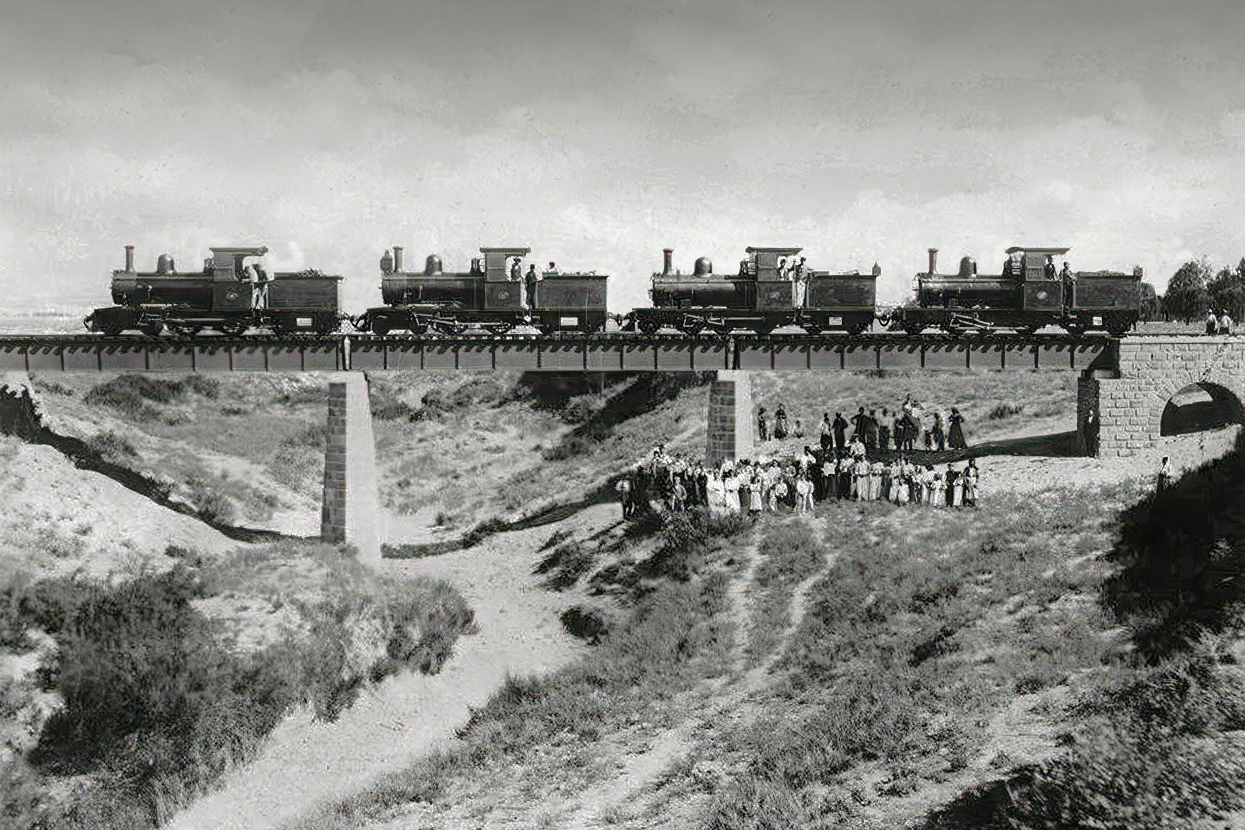
The networks originated with Britain’s 1878 occupation, inheriting Ottoman dirt tracks before launching surveys for modernization. Early efforts focused on military roads, like the 1880s Troodos route for troop access during summer heat. By the 1890s, under High Commissioner Walter Sendall, public works expanded with loans for harbors and railways, though the latter was short-lived from 1905 to 1951. The 1920s Crown Colony status accelerated projects, with the Public Works Department employing locals for macadam roads using crushed stone for durability. World War I and II repurposed them for military logistics, with bridges reinforced for tanks.
The interwar period saw irrigation dams like those at Lefka, drawing on Egyptian models via British expertise. During the 1950s Cyprus Emergency, roads facilitated counterinsurgency but were sabotaged by EOKA, prompting armored patrols. Post-independence in 1960, the Republic inherited and expanded the system, with EU funding since 2004 modernizing sections. The 1974 invasion divided networks, but southern upgrades continued. Climate data since 1960 shows warmer conditions eroding asphalt by 15%, urging resilient designs. Historical texts like colonial reports note transformations, from mule paths to motorways, evolving under governors like Sir Ronald Storrs.

Features of Roads, Bridges, and Public Works
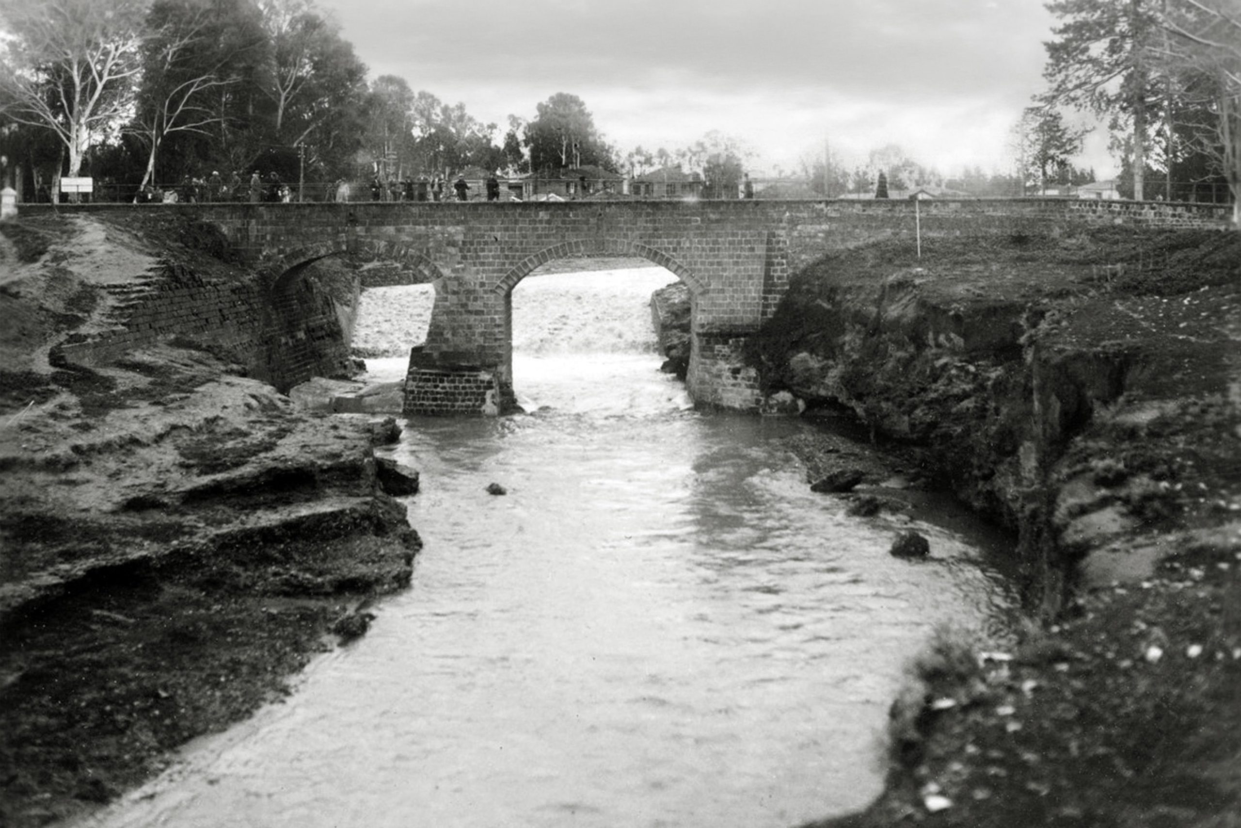
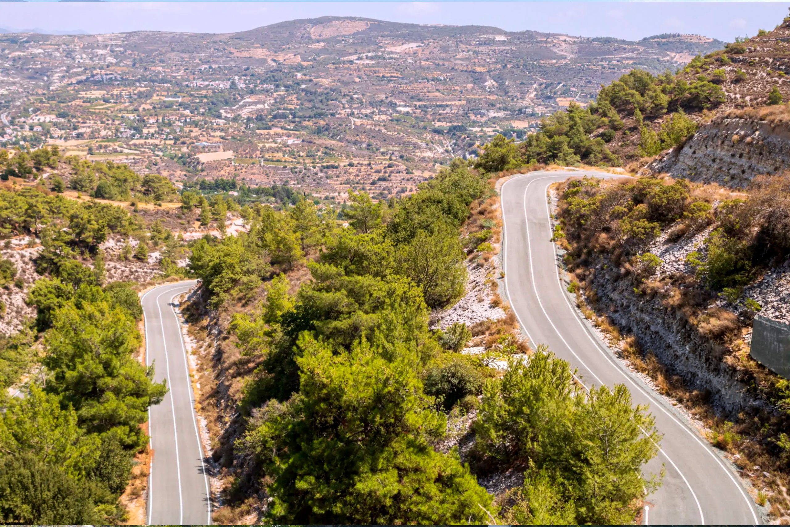
British roads featured gravel bases with tar sealing for dust control, winding through hills with gradients under 10% for vehicles, like the Platres road with hairpin turns. Bridges, such as the Venetian-inspired ones in Kyrenia, used local stone with multiple arches to span wadis, resisting flash floods.
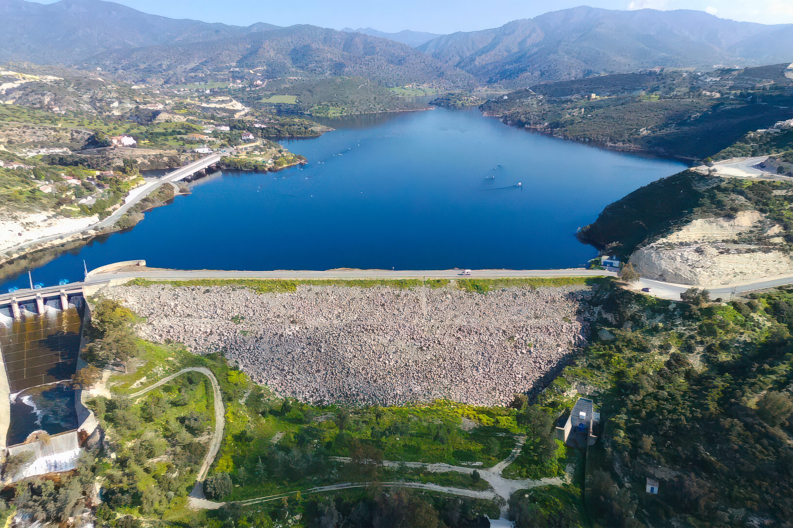
Public works included dams with earthen embankments and spillways, like the 1968 Germasogeia, though started colonially, irrigating 5,000 hectares. Telegraph and postal systems along roads used poles for wires, enabling rapid communication from Nicosia to outposts. Materials sourced locally reduced costs, with quarries supplying aggregate. In seismic zones, flexible designs prevented cracks, while rural bridges doubled as community hubs. Temperature extremes drove seasonal maintenance, with winter rains causing potholes repaired in summer. These features supported trade, with ports like Famagusta linked to hinterlands, boosting exports by 50% in the 1930s. Administrative oversight ensured standardization, with district engineers managing projects that integrated mobility with surveillance.
Notable Aspects That Highlight Its Uniqueness
One captivating feature is the Troodos Mountain Road, Cyprus’s first major colonial artery, winding 70 kilometers with scenic overlooks that symbolized access to highland retreats for British officials. The networks hold the record for transforming an island with no railways post-1951 into a road-dependent economy, with over 1,000 bridges by 1960. Rare elements like the Akaki Dam, an early concrete structure, blend engineering with aesthetics. Legends claim roads followed ancient paths haunted by Ottoman spirits, tying to folklore in colonial diaries. Adaptations include wartime camouflage on bridges, studied for military history, with replicas in museums. Surveys reveal hidden tunnels under some roads for drainage, inspiring engineering art. The systems’ panoramic routes create “scenic drives,” evoking imperial grandeur in spring blooms.
Deeper Impacts for Society
These networks profoundly impacted Cyprus’s society, enhancing trade by connecting farmers to markets, reducing isolation and boosting GDP through exports, but also enabling resource extraction that favored British interests. They supported social mobility, with improved access to education and healthcare, yet deepened inequalities by prioritizing urban areas. This fostered economic webs: roads facilitated tourism in the 1930s, bridges aided irrigation for agriculture, and works created jobs for 10,000 locals. Socially, they influenced migration patterns, with villagers relocating for opportunities. Politically, they symbolized control, aiding suppression during emergencies but sparking resistance like roadblocks. The balance sustained development amid exploitation, hosting diverse uses, but post-colonial divisions risked neglect, per EU reports predicting upgrades by 2100. Human impacts include local labor in construction, as in socio-economic studies. The networks nurtured biodiversity corridors, symbolizing connectivity in ecosystems.
Colonial Road and Infrastructure Networks in Cyprus Today
As of 2026, colonial road and infrastructure networks remain Cyprus’s backbone, with over 80% of original routes in use, upgraded with asphalt and EU-funded highways. Climate change alters patterns, with 2°C warmer temperatures since 1960 increasing erosion by 20%, leading to resilient materials. Preservation faces threats from urbanization, countered by Antiquities protections since 2010 for historic bridges. Modern adaptations include smart traffic systems, boosting efficiency by 25%. These networks shape mobility, with events like Heritage Road Tours celebrating history, blending past with eco-tourism generating €2 million annually.
Exploring Colonial Routes Today
Visitors can still trace many colonial-era roads across Cyprus, especially in the Troodos Mountains and between historic towns such as Nicosia, Limassol, and Paphos. Several stone bridges from the British period remain in use or preserved as heritage landmarks. Scenic drives along these older routes reveal how colonial engineers connected remote villages with commercial centers.
A Network of Colonial Transformation
Colonial Roads and Infrastructure Networks, British-built roads, bridges, and public works that transformed mobility, trade, and communication across the island, define Cyprus’s historical diversity. This pattern’s balance has fostered unique progress and human ingenuity, from colonial eras to modern challenges. Knowing it deepens appreciation for Cyprus as a resilient connected haven. Engagement with its paths evokes wonder at history’s routes. In a changing climate, it reminds of the need to safeguard this delicate balance.