The Lorovounos Hiking Trail (sometimes spelled Lourovounos) is a short but historically significant trail located in the dramatic coastal mountains of Cyprus. Nestled within the Tylliria region, near the secluded village of Alévga and the coastal community of Pachyammos, the trail primarily serves as a physical tribute to the island’s modern history.
Winding up toward the top of a prominent hill, it provides hikers with an immersive natural environment that transitions quickly from dry agricultural landscapes to a solemn high-elevation lookout. It is an excellent trek for those who appreciate military history, quiet countryside, and panoramic vistas of the Mediterranean coastline.
Lorovounos Hiking Trail Overview
- Location: Near Alévga and Pachyammos, Paphos District, Western Cyprus.
- Distance: 2 to 3.5 kilometers (approximately 1.2 to 2.2 miles) depending on the selected route.
- Route Type: Linear (with local loop alternatives over the summit).
- Difficulty: Category 1 to 2 (Easy to Moderate).
- Elevation Gain: Approximately 125 to 148 meters (410 to 486 feet).
- Duration: 40 minutes to 1 hour.
- Best Time to Visit: Winter and Spring (December to April) for the most comfortable temperatures and blooming flora.
- Terrain: Predominantly wide dirt forest roads transitioning into a steep, narrow, rocky footpath near the peak.
The Geography and Setting of Alévga and Tylliria
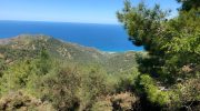
To fully understand the context of the Lorovounos trail, one must grasp the unique geography of the northwest coast of Cyprus. The trail sits within the Tylliria administrative region, perched above the road that connects the villages of Pachyammos and Kato Pyrgos. The terrain here is characterized by isolated volcanic hills that drop sharply down to meet the blue waters of the Chrysochou Bay.
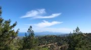
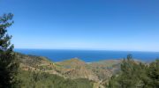
The trail reaches a peak elevation of approximately 659 meters above sea level. Because it stands directly over the coast, the climb offers hikers an elevated perspective over the surrounding landscape. To the west lies the coastal town of Pachyammos, while the east reveals Kato Pyrgos and the enclaved, protected military buffer area of Kokkina.
Geologically, the Lorovounos trail cuts through thin, stony soils over igneous and weathered sedimentary rock. This makes the trail predominantly exposed to the elements, with very little natural shade along the ascent. The exposed nature of the terrain means that it acts as a wind-swept balcony overlooking the sea.
Flora and Fauna Along the Trail
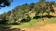
The dry, exposed mountain slopes around Alévga feature flora that has adapted specifically to harsh sun and minimal rainfall. While it does not feature dense forest canopies like the Troodos or Paphos forests, it offers a distinct Mediterranean scrubland ecosystem.

Plant Life
- Scrubland Species: Much of the trail passes through phrygana—low-lying bushes that release natural oils. These include wild thyme, spiny burnet, and thorny broom.
- Orchids: During late winter and early spring, this dry landscape becomes surprisingly vibrant. Attentive hikers can find various species of wild orchids blooming along the dirt edges of the path.
- Exposed Sections: Aside from a few scattered pine trees near the summit’s narrow footpath, there is almost no shade on the open forest road sections of this trail.
Wildlife and Birdwatching
The coastal mountain range around Kato Pyrgos and Alévga attracts both resident and migratory species of birds.
- Avian Species: The rising thermal currents from the coast draw in predatory birds such as the long-legged buzzard and the kestrel. Smaller local species, including the Cyprus warbler, are commonly seen flitting between the low bushes.
- Reptiles: During the warm months, lizards such as the starred lizard (Laudakia stellio) can be seen darting across the dry limestone surfaces.
Detailed Walkthrough and Points of Interest
The Lorovounos Nature Trail functions as a direct route that climbs to a dedicated viewpoint and memorial site. The trail transitions between distinct walking surfaces and offers a brief choice of paths near the summit.
Starting Point and Initial Ascent
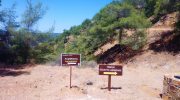
The trailhead begins at Akoni, the location of the Fallen Heroes Monument of Lorovounos, situated on the primary road between Pachyammos and Kato Pyrgos. The early section consists of a wide, unpaved forest track that climbs gently through the rural countryside. Walking here is straightforward, and hikers are guided by general wooden directional signage.
The Peak Selection: Forest Road vs. Footpath
Roughly halfway through the 2-kilometer path, hikers reach a key decision point near the upper ridge.
- The Old Forest Road: Taking this route offers a longer, more gradual climb. It winds smoothly up the side of the hill, making it suitable for casual walkers who want to avoid steep inclines.
- The Footpath: Choosing the direct footpath leads hikers up a steep, rocky, and less-frequently maintained trail. This narrower route climbs directly over the ridge of the mountain. While it is physically more demanding, it provides extra shade and distinct trail markers that guide hikers through the rocks.


