
The Paphos Forest hides a secret world where history meets the wild. You walk on trails that medieval merchants once used to transport copper and gold. These paths connect three spectacular stone structures known as the Venetian Bridges. Deep valleys and thick cedar trees create a quiet atmosphere for every visitor.
The air feels cool even when the sun shines bright above the canopy. You hear the sound of water as it flows under old arches. This journey offers a glimpse into the past of Cyprus. It remains a top choice for those who love quiet walks. Every step reveals a new view of the green landscape.
Trail Overview
- Location: Paphos Forest, Limassol/Paphos District, Cyprus
- Distance: 17 km (Full linear trail)
- Route Type: Point-to-Point (Linear)
- Difficulty: Moderate
- Elevation Gain: 600 meters
- Duration: 5 – 6 hours
- Best Time to Visit: March to June or September to November
- Terrain: Dirt tracks, forest paths, and rocky slopes
The Historical Significance of the Venetian Bridges
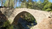
The Venetian era in Cyprus left a permanent mark on the island. Engineers built these bridges during the 16th century to facilitate trade between mountain mines and the coast. Mules carried heavy loads across these stone spans every day.
The architecture reflects a need for strength and durability against mountain floods. You see precise stonework that survives centuries of weather and use. Each bridge sits at a strategic point over the Diarizos river or its tributaries. They represent the peak of medieval transport technology in the Mediterranean region. Today they serve as monuments to a time of great commerce and toil.
Starting the Journey at Tzelefos Bridge
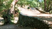
Tzelefos Bridge stands as the most famous landmark on this route. It is the largest stone bridge on the island and draws many photographers. The arch spans a wide section of the river where the water pools into clear ponds. Large plane trees surround the base of the structure.
Their leaves provide shade for hikers who start their trek here. You notice how the stones fit together without modern cement. The design allows the bridge to blend into the natural environment. It feels like a part of the earth itself rather than a man-made object. This spot marks the beginning of a deep immersion into the forest.
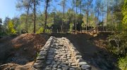
The Path Toward Elia Bridge
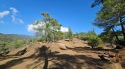
The trail leads you away from the water for a short time. You climb steady slopes that offer views of the Xyliatos dam in the distance. The ground consists of dry earth and pine needles. Small shrubs like rockrose and thyme scent the air. You move through dense thickets of golden oak which is the national tree of Cyprus.
This section requires focus because the path narrows at certain points. However the incline stays manageable for most fit walkers. Soon you hear the river once again as you approach the second bridge. Elia Bridge sits in a more secluded spot than Tzelefos. It possesses a sharp pointed arch that looks elegant against the green leaves.
Natural Biodiversity of the Paphos Forest
Nature thrives in this protected zone of the island. You might spot the Mouflon which is a rare wild sheep unique to Cyprus. They are shy creatures that move fast through the brush. Birds like the Short-toed Treecreeper or the Cyprus Wheatear fly between the branches. The forest acts as a sanctuary for species that disappear from urban areas.

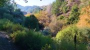
Water stays in the river beds throughout the year which supports life. Rare ferns grow in the damp crevices of the river banks. Moss covers the north side of the rocks and trees. This ecosystem depends on the high rainfall that the Troodos mountains receive. You witness a balance between flora and fauna that remains undisturbed.
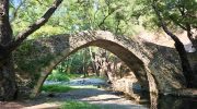
Reaching the Kelephos and Roudia Bridges
The final stretch of the long trail takes you toward Roudia Bridge. This bridge stays hidden deep within the forest core. Few people reach this point because it sits far from the main roads. The silence here feels absolute and heavy.
Huge boulders sit in the stream bed near the bridge. These rocks show the power of the water during the winter months. The bridge itself stands as a testament to the skill of the old masons. It remains sturdy despite the isolation and the lack of repairs. You feel a sense of achievement when you stand on its stone deck. It is the quietest part of the entire trek.
Seasonal Changes On The Trail
Each season brings a different mood to the Venetian paths. Spring offers a burst of color as wildflowers bloom on the slopes. The river flows with force as snow melts from the peaks. Summer provides a cool escape from the heat of the beach. Autumn turns the plane tree leaves into shades of orange and gold.
Winter makes the trail difficult due to mud and rain. However the sight of mist in the valleys looks magical. Most people prefer the mild temperatures of the spring months. The scents and sounds reach their peak during this time of year. Every visit feels unique because the landscape shifts its character.
The Venetian Bridges Nature Trail connects the soul to the history of Cyprus. You walk where ancestors walked while you enjoy the purest air. The stone arches remind us that humans can build things that last. Nature claims the space around the bridges but the structures stand tall.
This hike challenges the body and clears the mind. You leave the forest with a deep respect for the past and the wild. It is a journey that everyone should take at least once. The memory of the stone arches stays with you long after the walk ends.


