The Argaka Long Trail sits within the beautiful Paphos Forest on the island of Cyprus. This path offers a unique look at the natural landscape of the region. Hikers walk through pine trees and enjoy views of the Mediterranean Sea.
The trail provides a calm space for those who seek a quiet walk in nature. It remains a popular spot for locals and visitors who appreciate the outdoors. Every step reveals a different part of the local flora and fauna. This route serves as a perfect example of the wild beauty found in the Akamas area. Experience the peace of the forest today.
Trail Overview
- Location: Argaka Village, Paphos District, Cyprus
- Distance: 6.2 miles (10 km)
- Route Type: Loop
- Difficulty: Moderate
- Elevation Gain: 450 meters
- Duration: 3 – 4 hours
- Best Time to Visit: January–May or October–December
- Terrain: Rocky paths, dirt forest tracks, and steep inclines
Geographic Importance of the Argaka Region
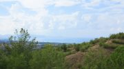
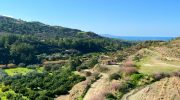
Argaka occupies a spot on the edge of the Paphos Forest. This forest contains a large variety of endemic plants. The trail starts near the village and moves upward into the hills. It overlooks the Chrysochou Bay.
This bay features blue water that contrasts with the green trees. The elevation allows for a wide view of the northern coast. Such a position makes the trail a vital part of the local ecosystem. It connects the coastal life with the mountain environment.
Flora and Fauna Along the Route
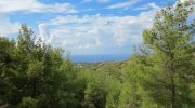
The vegetation consists mainly of Calabrian pine trees. These trees provide shade for much of the walk. Wild herbs like thyme and lavender grow near the path. They release a pleasant scent into the air. Birds like the Cyprus Wheatear often fly past the trees.

You might see a mouflon if you stay quiet. This wild sheep lives deep within the Paphos Forest. Reptiles also bask on the rocks during the day. Each species plays a role in the balance of this habitat.
Historical Context and Local Culture
Argaka has a long history of agriculture and forestry. People in the village once relied on the forest for wood. They also farmed the fertile land near the coast. The trail follows old paths used by foresters in the past. These paths now serve as a bridge to the history of the island. You can see old fire lookouts at certain points. These structures show how the community protects the forest. Respect for the land remains a core value for the local people.
Preparation ensures a safe trip through the hills. The sun stays strong even in the winter months. You must carry enough water to stay hydrated. Solid boots protect your feet from the sharp rocks. Cell phone signals can drop in the deep valleys. It helps to bring a map of the area. Tell someone your plans before you start the walk. Check the weather report for any signs of rain. Storms can make the dirt tracks slippery and dangerous.
Technical Details of the Terrain
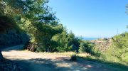
The ground varies from soft pine needles to hard rock. Some sections feature loose stones that require careful balance. The ascent starts early in the walk. This climb tests your stamina but rewards you with views. The loop structure means you return to the start point. This makes transport logistics simple for every hiker. No specialized gear besides good shoes is necessary. The path remains well-marked with signs and paint. Follow these markers to stay on the correct route.
Many spots offer perfect frames for a camera. The peak of the trail provides a full view of the bay. You can see the Pomos peninsula in the distance. The light at sunset creates deep shadows on the hills. Photographers often visit during the golden hour. The contrast between the red earth and green trees looks sharp. Capture the texture of the old bark on the pine trees. These images tell the story of the rugged Cypriot landscape.
Community Involvement and Maintenance
The Department of Forests maintains the Argaka Long Trail. They clear fallen branches and update the signs. Local volunteers also help keep the area clean. This effort keeps the trail open for everyone to use. Tourism provides support for the small shops in Argaka.
Hikers often stop for a meal after their walk. This cycle benefits both the people and the land. Conservation remains a top priority for the forest officials. They work to prevent fires and protect the wildlife.
Navigation and Trail Markers
Markers appear at regular intervals along the path. They consist of wooden signs or color codes on rocks. These guides prevent hikers from lost paths in the woods. The main loop stays clear of thick brush. Some side paths lead to private orchards or farms.

Stick to the main route to avoid a trespass. GPS devices work well on the higher ridges. The forest floor can block signals in the deep ravines. Trust the physical signs as your primary source of direction.


