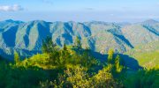
Stavros tis Psokas Forest sits at 900 meters elevation in the Paphos Forest, located roughly halfway between the coastal towns of Paphos and Polis Chrysochous. This remote forest station covers part of the 603 square kilometers that make up the largest and most extensive forest complex in Cyprus.
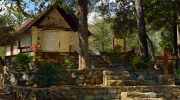
The area takes its name from the Stavros tis Psokas river, a tributary of the Chrysochou River that flows through this mountainous region. The forest station serves as the operational headquarters for the Paphos branch of the Department of Forests and has become a popular destination for nature enthusiasts who want to experience Cyprus beyond its beaches.
Historical Background
The Paphos Forest extends from near sea level up to the peak of Tripylos at 1,352 meters. The climate is typically Mediterranean with prolonged dry and hot summers and short, rainy, but mild winters. Winter temperatures average 10°C at the lowest elevations and 5°C at the highest altitude, while summer brings 35°C in the lowlands and 22°C at the peaks. Annual rainfall ranges from 450mm in lower areas to 900mm at the mountain tops.
The forest has provided resources for human populations for thousands of years. Historical records show Cyprus was once an important shipbuilding center and timber exporter, which led to extensive forest exploitation. By the 19th century, Cyprus had the largest goat population of any Mediterranean island, resulting in severe overgrazing and deliberate burning of forests to produce fresh grass. These practices destroyed much of the island’s original forest cover.
The establishment of the Stavros tis Psokas forest station in the 1940s marked a turning point in forest management. The main buildings, constructed in 1947 and 1948, still stand today as stone and red brick structures from that era. The station was created to protect and manage this crucial forest ecosystem and coordinate conservation efforts. In 2005, the Paphos Forest received designation as a Special Protection Area, recognizing its exceptional value for biodiversity. Two parts of the forest, Cedar Valley and Mavri Gkremmi (Black Cliffs), have been given protected status as Nature Reserves.
The Forest Landscape and Main Features
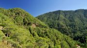
The site includes fourteen habitat types, among which the most extensive and continuous forest ecosystem in Cyprus with the largest and most representative pine forest ranging from the lowlands (200m) up to the peak of Tripylos 1352m. The dominant tree is the Calabrian pine (Pinus brutia), which covers most of the lower mountains and stretches down to the plains. At higher elevations, Black Pine takes over.

The forest contains priority habitat types including the unique endemic cedar forest and scrub vegetation of the endemic Golden Oak (Quercus alnifolia). Riparian vegetation appears at all elevations, featuring numerous broadleaf species such as Oriental Plane, Oriental Alder, Bay Laurel, and Common Myrtle. In the lowlands, trees become sparse and give way to small shrubs and grasslands that create dense vegetation of high ecological value.
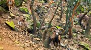
The mouflon enclosure sits near the forest station at the beginning of the Agios Theodoros valley. This fenced area allows visitors to observe the Cyprus mouflon, the island’s largest wild land mammal, in a setting that mimics their natural habitat. The enclosure provides one of the few reliable opportunities to see these elusive animals, which typically remain hidden in the forest and are most active during cool hours.
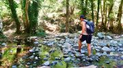
Two nature trails start from Stavros tis Psokas. The Chorteri nature trail and the Selladi tou Stavrou nature trail both offer spectacular views of the Paphos Forest while passing through diverse vegetation zones. A longer trail extends 6.3 miles (10 kilometers) through a gorge with lush vegetation, featuring an elevation gain of 1,082 feet.
Notable Facts About the Area
The number of flora species found in the Paphos Forest has been estimated to exceed 600. Fifty of these are endemic to Cyprus. Three plant species receive protection under conservation directives, including the Cyprus Cedar (Cedrus brevifolia), which grows only in this forest and nowhere else in the world. Other endemic species include Kykko Mustard (Eryssimum kykkoticum), Kykko Buttercup (Ranunculus kykkoensis), and cordate-leaved Oregano (Origanum cordifolium).
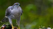
About 100 bird species have so far been recorded in the Paphos Forest, of which 40 are permanent residents, 6 are endemic to Cyprus. The forest is considered the main habitat for Bonelli’s Eagle and Goshawk, both protected species. The area serves as critical habitat for nesting raptors, supporting the highest number of breeding Bonelli’s eagles and Goshawks in Cyprus. Griffon vultures no longer breed here but regularly visit to drink from springs in the Tripylos area.
The forest contains 22 different reptile species, with the Cyprus Whip Snake being the most important. Numerous insect species inhabit the area, many of them endemic, including two protected by conservation directives. Amphibians include three frog species found on the island and the freshwater crab (Potamion potamios).
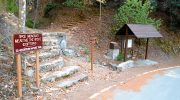
The forest station accommodates up to 600 people at its picnic site, which provides dedicated fire places for cooking, toilets, and potable water at no charge. A small convenience store near the station sells refreshments. The camping site can handle up to 60 tents and 6 to 7 caravans, totaling about 150 people, with facilities including potable water, toilets, and showers.
Planning a Visit to Stavros tis Psokas
Access to Stavros tis Psokas requires commitment, as the location sits approximately 30 kilometers from both Paphos and Polis Chrysochous. Two main routes serve the area, one from Panagia village and another from Lysos village in the Polis Chrysochous region. The roads become curvy after leaving the main Paphos to Polis highway, requiring reduced speed and careful driving. The journey takes roughly one hour from either coastal town.

The forest station welcomes visitors year-round, though spring (March to May) and autumn (September to November) provide the most comfortable temperatures for outdoor activities. Summer nights can be cool even when days are hot, while winter brings cold temperatures and occasional snow at higher elevations. The area remains humidity-free during summer, making it a pleasant escape from coastal heat.
The mouflon enclosure operates daily and provides the best opportunity to observe these rare animals. Cyprus mouflons are shy and difficult to approach in the wild, preferring to roam during cool hours. They are mainly seen in winter months during the afternoon or early morning during summer. The enclosure allows close observation while the animals graze and roam in an environment designed to mimic their natural habitat. Visitors must follow park rules by not feeding the animals and maintaining a safe distance from the fence.
Why This Forest Deserves Recognition
Stavros tis Psokas Forest offers something increasingly rare in the modern Mediterranean. This is a place where ancient pine trees still stand, where endemic species continue to survive, and where the largest wild mammal on Cyprus finds refuge. The forest demonstrates that conservation efforts can succeed, as evidenced by the mouflon population’s recovery from near extinction to 3,000 individuals.
The forest connects modern Cypriots to their island’s natural history. These mountains and valleys have supported life for millennia, from Neolithic settlers who brought the first mouflons to medieval monks who found refuge in these forests, to contemporary families who camp under the stars and introduce their children to wildlife. Understanding this continuity helps people recognize their role in protecting Cyprus’s natural heritage for future generations.