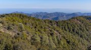
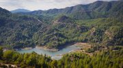
The Troodos Mountains occupy the central part of Cyprus, covering approximately 1,147 square kilometers or about 15 percent of the island. UNESCO designated Troodos as a Global Geopark in 2015 due to its exceptional geological significance. The mountain range represents an ophiolite, which is an uplifted fragment of oceanic crust and upper mantle that formed 92 million years ago during the Upper Cretaceous period.
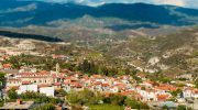
The highest peak, Mount Olympus, reaches 1,952 meters above sea level. What makes Troodos extraordinary is that the deepest rocks now sit at the highest elevations due to a dome structure created by tectonic forces. Visitors walking through Troodos can literally travel from the Earth’s upper mantle to the ancient seafloor within a single day.
The area contains 38 geosites that display this geological marvel, making it one of the most complete and best preserved ophiolite sequences in the world. Scientists consider Troodos the gold standard for understanding how oceanic crust forms and evolves.
How ocean crust ended up on land
The Troodos ophiolite formed in the Neotethys Ocean by seafloor spreading above a subduction zone approximately 92 to 82 million years ago. At that time, the African and Arabian tectonic plates were converging with the Eurasian plate. New oceanic crust formed as magma rose from the mantle and solidified at the spreading center. The process created distinct layers that geologists can identify today, starting with ultramafic mantle rocks at the base, followed by gabbro intrusions, sheeted dikes, pillow lavas, and finally seafloor sediments at the top.
Around 90 million years ago, this section of ocean floor sat 8,000 meters below sea level. Tectonic compression caused the entire sequence to be thrust upward and emplaced onto continental margins. The uplift was uneven and centered around Mount Olympus, creating a dome structure. Subsequent erosion removed younger sediments from the summit, exposing the oldest and deepest rocks at the highest elevations. This creates an inverted topography where hikers can walk from mantle rocks at the peaks down to volcanic seafloor rocks at lower elevations. The uplift continues today as tectonic forces remain active in the region.
The complete ophiolite sequence exposed
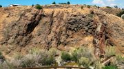
Troodos displays the most stratigraphically complete ophiolite sequence known to science. The deepest layer consists of peridotite and ultramafic rocks from the Earth’s upper mantle, predominantly composed of the greenish mineral olivine. Above this lies layered gabbro, formed from slow cooling of magma underground. The next layer contains unlayered gabbro that transitions into the famous sheeted dike complex.
This remarkable formation consists of countless vertical basalt dikes injected one inside another, with each new dike splitting the previous one. Ian Gass discovered this sheeted dike complex during his mapping work in Troodos, and the finding proved crucial to understanding seafloor spreading.
Above the dikes sits the volcanic section, dominated by pillow lavas that formed when molten basalt erupted underwater and cooled rapidly in contact with cold seawater. The distinctive pillow shapes are visible throughout the mountains. The uppermost layer consists of chemical sediments that formed on the ancient ocean floor. This complete vertical sequence allows scientists to study processes that normally occur kilometers below modern oceans.
Black smokers and copper riches
Ancient hydrothermal vents called black smokers created the copper deposits that made Cyprus famous. At the oceanic spreading center 92 million years ago, seawater seeped down through cracks in the newly formed crust. Magma heated this water to extreme temperatures, causing it to extract copper, zinc, iron, gold and silver from the surrounding rocks. The superheated mineral rich water then rose back to the seafloor and erupted through black smoker chimneys.
When the hot fluid met cold seawater, metals precipitated out and accumulated around the vents, forming massive sulfide deposits. These ancient black smoker mounds are now exposed throughout the Troodos Mountains as volcanogenic massive sulfide deposits. Cyprus has been mined for copper for over 6,000 years, with at least 30 major deposits identified in the pillow lava section. The very name Cyprus likely derives from the Greek word Kupros meaning copper.
The island supplied the Mediterranean world with copper through Bronze Age, Classical, and Roman periods. The Skouriotissa mine, possibly the world’s longest producing copper mine, began operations in 1914 and continues extraction today. Ancient slag heaps around mines date to 2000 BC, demonstrating millennia of continuous exploitation.
A natural laboratory for earth science
Geologists from around the world travel to Troodos to study processes that normally happen deep beneath oceans. The exposed ophiolite sequence provides a three dimensional view of oceanic crust formation that cannot be obtained anywhere else with such completeness. Foreign universities regularly conduct field schools in the mountains, training geology students on fundamental concepts of plate tectonics and seafloor spreading. The discovery of the sheeted dike complex at Troodos directly contributed to the development of plate tectonic theory in the 1960s.
Researchers realized that seafloor spreading was the only plausible mechanism to create such a formation. When combined with evidence from deep sea trenches, these insights helped scientists piece together the complete theory of plate tectonics. The Troodos ophiolite serves as a reference model for understanding oceanic crust worldwide. The dome structure created by uplift makes it exceptionally easy to observe the big picture of geological architecture. Visitors standing at belvedere viewpoints can see lithologies, fault lines, and large scale structures laid out concentrically around the central peak.
The Geopark Center and education programs
The Troodos Geopark Visitor Centre occupies a restored early 20th century elementary school at the rehabilitated Amiantos asbestos mine. This impressive listed building features historic fireplaces in every room and a beautiful internal courtyard. At the entrance, a geological garden displays all rock types found in the area arranged in stratigraphic order, representing the complete ophiolite sequence. Inside, exhibits explain the formation and uplift of the mountains through demonstration kits, geological specimens, mining artifacts, and documentary films.
A lecture room accommodates school visits and educational programs. The center receives thousands of children and visitors every year. The nearby Botanical Gardens showcase the endemic plants that thrive on the unique substrate created by ophiolite rocks. The Environmental Information Centre in Troodos square and the Environmental Education Centre in Pedoulas village complement the Geopark Centre.
The local community, represented by the Troodos District Development Agency, operates the center. Geological and nature trails throughout the mountains allow visitors to explore specific features with interpretive signage explaining the rocks and formations they encounter.
Visiting Troodos to see Earth’s interior
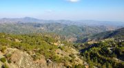
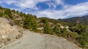
The Geopark is located in central Cyprus with its boundary roughly following the extent of the ophiolite complex. Access is easy from all major cities, with Nicosia lying 57 kilometers to the northeast. Multiple roads climb into the mountains from the coastal plains. The main E801 road connects Limassol with Troodos square, while the B8 approaches from Paphos. Well signed hiking trails including the Teichia Tis Madaris Geo-Trail allow close examination of sheeted dikes and other formations.
The Akaki River Gorge provides spectacular exposures of submarine pillow lavas intruded by sheeted dikes. Geological maps and trail guides are available from the Visitor Centre and tourism offices. Spring and autumn offer the best weather for geological exploration, with comfortable temperatures and clear visibility.
Summer brings crowds to the mountains seeking cooler temperatures, while winter can bring snow to higher elevations. Many geological features are visible directly from roads, but proper hiking boots and outdoor gear allow deeper exploration. Information panels at geosites explain what visitors are seeing and why it matters to understanding Earth processes.
Why this designation matters globally
Troodos UNESCO Global Geopark protects and promotes understanding of geological heritage that belongs to all humanity. The mountains provide irreplaceable evidence of how oceanic crust forms, how tectonic plates interact, and how mineral deposits accumulate at mid ocean ridges. The completeness and exposure quality of the ophiolite sequence makes Troodos a natural laboratory that has educated thousands of geoscientists.
The designation ensures that future generations can study these rocks and make new discoveries. UNESCO recognition brings international attention and tourism that supports local communities economically while encouraging conservation. The Geopark demonstrates how geological heritage can drive sustainable development in rural areas.
For Cyprus, Troodos represents national pride in a geological wonder that puts the small island at the center of earth science research. The mountains anchor Cypriot identity as the place where ocean became land, where copper built ancient civilizations, and where modern science unlocked secrets of plate tectonics that reshaped our understanding of how Earth works.