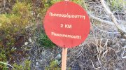
The Pissouromoutti Nature Trail sits within the Akamas Peninsula near the Smigies picnic site. This route follows a circular path around a prominent limestone hill. Every step reveals a wide view of the Chrysochou Bay and the north coast. The air carries the scent of wild thyme and carob trees throughout the year.
This trek serves as a physical challenge for those who seek high vantage points. It offers a direct look at the rugged beauty of the Paphos district. Each segment provides a unique perspective of the coastal cliffs and the forest. The trail remains a favorite for local nature lovers.
Trail Overview
- Location: Akamas Peninsula, Paphos District, Cyprus
- Distance: 1.9 miles (3 km)
- Route Type: Loop
- Difficulty: Moderate
- Elevation Gain: 525 feet (160 meters)
- Duration: 1.5 hours
- Best Time to Visit: January to May
- Terrain: Rocky paths, dirt tracks, and limestone outcrops
The Start at Smigies Picnic Ground
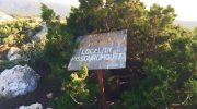
The trek begins at the Smigies picnic area where the forest feels dense and cool. A clear sign marks the trailhead near the entrance of the park. The path stays level for the first few hundred meters of the journey.
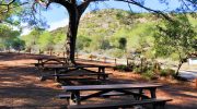
Tall juniper trees line the track and provide a bit of shade. The ground consists of hard earth and small stones that crunch under boots. Local birds call from the branches but stay out of sight. This section allows the body to prepare for the ascent ahead. The calm of the woods is a welcome break from the city.
Technical Ascent and Path Elevation
The incline starts almost at once as the trail turns toward the hill. Steady effort is necessary to maintain a good pace on the slope. Loose gravel covers parts of the track and requires focus for safety. This part of the ridge consists of limestone rock formations.

These stones create a pale look to the ground under the bright sun. The gradient stays consistent until the route reaches the middle ridge. This part tests the breath as the path climbs above the sea level. Every meter of gain improves the view of the valley below.
Botanical Diversity
Juniper shrubs dot the landscape and stand as tough guards of the peak. The mastic tree also grows in the rocky soil near the base. These plants have thick leaves that stay green in the dry months. This trait helps the flora survive the long summers on the island.
No natural water taps exist on the higher parts of the loop. The soil is thin and rocky which limits the plant life to hardy species. Rare cyclamens appear in the winter when the rain provides enough moisture. Wild sage and rockrose scent the air as the wind moves.
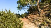
Navigation Along the Limestone Cliffs
The path follows the edge of the limestone peak once the main climb ends. This part of the trek offers a total view of the Mediterranean sea. A person sees the dark blue water that meets the sky on the horizon.
The track stays narrow with sharp drops toward the forest floor. It is vital to watch the ground to avoid a trip on a root. The wind picks up speed as the path leaves the shelter of the trees. This breeze provides a cool relief after the heat of the ascent. The lack of tall woods allows for a clear sight.
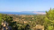
Observation Points and Panoramic Vistas
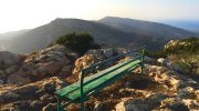
The trail reaches a high point where a wooden bench sits for a rest. This spot provides a 360 degree view of the entire Akamas Forest. A hiker can spot the Lara beach to the south on a bright day. The north coast toward Polis looks like a map spread out below. The sun feels intense here because the canopy is thin and sparse.
This exposure makes a hat and sun block a vital part of the pack. The geology here shows the history of the land as it rose from the sea. Fossils sometimes appear in the rocks on the side.
Wildlife and Avian Activity on the Peak
Birds of prey often circle the thermals above the hill in search of food. The kestrel or even a rare hawk might appear on a lucky day. Lizards dart across the path and hide in the cracks of the stone. These reptiles regulate their heat on the warm surface of the track.

Snakes exist in the thick brush but they usually avoid the main path. It is best to stay on the marked track to avoid a surprise encounter. The sound of cicadas fills the air during the peak of the day. Nature thrives in this protected zone.
The Descent Toward the Forest Floor
The return leg of the loop starts with a descent back toward the start. The path moves through a more wooded area with a lot of shade. The ground feels soft under the boots because of the fallen leaves.
This part of the trek is much easier on the joints than the climb. Small wildflowers dot the grass under the shade of the bushes. The air feels cool as the path enters the deeper parts of the valley. The sounds of the picnic area become clear as the end nears. Each step down brings a sense of calm and success.
Environmental Care and Trail Etiquette
The Akamas Peninsula is a sensitive ecological zone that needs care. Visitors must stay on the marked path to protect the rare plants. No person should take stones or flowers from the park grounds. Trash must go back to the bins at the picnic site.
This help keeps the forest clean and safe for the wildlife. The Department of Forests works hard to maintain the signs and tracks. Respect for the rules ensures that the trail stays open for others. Nature is a gift that requires the help of every visitor to survive.


