Explore Cyprus with Our Interactive Map

Explore our top stories and discover ideas worth your time.

Salamis to Paphos Historic Routes

Salamis to Paphos Historic Routes

The story of Cyprus roads spans over 3,000 years, from Bronze Age trade routes to Roman highways and modern infrastructure. This network transformed the island from scattered settlements into a connected civilization, linking major cities and remote villages while facilitating trade across the Mediterranean. The earliest roads in Cyprus date back to the Bronze Age, when the island served as a crucial trading hub between the Aegean, Egypt, and the Levant. Cyprus became the principal intermediary station for Mycenaean Greece in accessing Middle Eastern markets, largely due to its copper resources in the Troodos Mountains. By the end of the Hellenistic period, the road network encircled the entire island. During the Late Bronze Age between 1400 and 1150 BCE, trade with Minoan Crete and Mycenaean Greece increased dramatically. Archaeological evidence shows that Mycenaean pottery exports to Cyprus surged to over 3,500 vases across nearly two centuries. These goods traveled along established land routes that connected coastal ports to interior settlements. Historical Context The Romans transformed Cyprus's road infrastructure after annexing the island in 58 BCE. The first Roman roads were funded directly by the Emperor, though by the Severan dynasty the island had grown wealthy enough to finance its own construction. Roads converged on Salamis, the main economic center, with minor roads radiating outward to connect the surrounding agricultural areas…

Read more
Landscape Driven Villages of Cyprus

Landscape Driven Villages of Cyprus

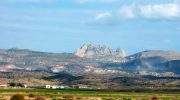
Cyprus villages evolved through intimate relationship between human settlement and natural terrain, creating communities shaped by mountains, valleys, water sources, and agricultural land. The island's dramatic geography, dominated by the Troodos Mountains rising to 1,952 meters and the northern Kyrenia Range reaching 1,024 meters, determined where people built homes and how they organized village life. Between these ranges lies the Mesaoria Plain, Cyprus's agricultural heartland where lowland villages spread across fertile flatlands. Mountain villages cling to steep slopes, terraced into hillsides at multiple elevations with buildings accessible from streets at different heights. This landscape adaptation created sustainable settlement patterns that persisted for millennia, balancing human needs with environmental constraints while maintaining agricultural productivity. The terracing, water management, and compact building forms demonstrate sophisticated understanding of terrain that allowed dense population while preserving productive farmland surrounding villages. Geography Determines Settlement Patterns Cyprus's two mountain ranges and central plain created distinct regional settlement types. Troodos foothill villages occupy elevations between 400 and 1,200 meters where mineral-rich volcanic soils support vineyards, fruit orchards, and olive groves. These villages developed around copper mining from the Bronze Age through the 20th century, combining agriculture with metallurgical industries that connected Cyprus to Mediterranean trade networks. Villages like Politiko-Troullia in the Troodos foothills prospered from copper resources less than one kilometer away while maintaining agricultural terraces on…

Read more
Kaledonia Waterfall Trail

Kaledonia Waterfall Trail

The Kaledonia Waterfall Trail offers one of Cyprus's most scenic forest hikes. This 3-kilometer nature trail follows the Kryos Potamos River through dense pine and oak forests in the Troodos Mountains, leading to a spectacular 12-meter waterfall at 1,330 meters elevation. The trail takes its name from the Kaledonia waterfall at its center point, though many maps also spell it Caledonia. The path maintains a mostly shaded route under tall pine trees along the riverbank, creating a cool microclimate even during Cyprus's hot summer months. The sound of rushing water accompanies hikers throughout the journey as they cross the Kryos Potamos River six to seven times before reaching the main cascade. The trail sits within Troodos National Forest Park, a protected area covering 9,147 hectares around Mount Olympus. Wooden bridges span the stream at key points, though hikers must also step across river stones polished smooth by centuries of water flow. Business Insider ranked this waterfall as the 14th best in Europe in 2015, bringing increased international attention to what was previously a lesser-known local hiking destination. Historical Background In 1878, a Scottish expedition visited the Platres region during the early period of British colonial administration in Cyprus. When the Scots encountered the waterfall and surrounding landscape, they found remarkable similarities to the waterfalls and forested gorges of their homeland.…

Read more