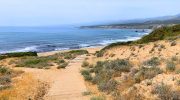
The Troodos Mountains cover one-third of Cyprus and rise to 1,952 meters at Mount Olympus. This massive range stretches across most of the western side of the island, offering cool pine-scented air, traditional villages, and winding roads that climb from sea level through multiple climate zones. These mountain routes provide a complete contrast to coastal Cyprus, both in landscape and atmosphere.

Three main routes connect Nicosia to the Troodos region, each offering distinct scenery and driving experiences. The most scenic path runs through Evrychou, Galata, Kakopetria, Platania, outside Kyperounta, Amiantos, and finally Platia Troodos. This route covers approximately 100 kilometers and takes between 90 minutes to two hours depending on traffic and stops.
The road features numerous curves and requires careful navigation, particularly for drivers unfamiliar with mountain conditions. Passing slower vehicles can be challenging on narrow sections, but the pure mountain driving experience rewards those who enjoy the combination of concentration and scenery. During winter months, heavy snow can make this route impassable without 4×4 vehicles or tire chains.
An alternative loops through Kalopanagiotis, Moutoullas, Pedoulas, and Prodromos before reaching Platia Troodos. This variation offers incredible scenery through the Marathasa Valley but comes with very narrow roads. The decorative walls along village streets create a distinctive character, though roadside parking by tourists can slow progress considerably.
The third option provides faster access when traffic becomes heavy. Each route delivers different perspectives on the mountain landscape, from dense pine forests to terraced hillsides with remaining vineyards.
The Limassol to Troodos Climb
The B8 road from Limassol to Troodos Square represents the shortest mountain access route at roughly 40 kilometers. The journey typically takes about 90 minutes due to elevation gain and winding curves. This route passes through wine villages and pine forests, offering cooler temperatures particularly welcome during summer months.

The road climbs steadily from sea level at Limassol to over 1,700 meters at Troodos Square, creating noticeable temperature drops. Summer temperatures at Troodos average 22 degrees Celsius compared to coastal highs exceeding 35 degrees. Winter brings snow from January to March, transforming Troodos into Cyprus’s only ski area.
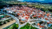
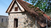
The route provides access to several important stops including the wine village of Omodos, known for its cobblestone streets, monastery, and family-run wineries. Traditional tavernas serve authentic Cypriot food, often concluding meals with small shots of homemade spirits. The village population of 300 permanent residents swells to 10,000 during peak summer periods.
Wine Village Routes Through Krasochoria
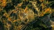
The Krasochoria Lemesou wine route winds through 20 villages on the southern slopes of Troodos, featuring the highest concentration of wineries in Cyprus. These wine villages, located at altitudes between 600 and 900 meters, have produced wine for centuries. The dry climate and unique geology contribute to high-quality grapes, primarily indigenous Xynisteri white and Mavro red varieties.

The route begins near Limassol and passes through villages including Koilani, Omodos, Vouni, Arsos, and Vasa. Each village maintains traditional Cypriot architecture with narrow cobblestoned passageways, stone houses, and atmospheric squares. Sixteen wineries dot this route, from small family operations to modern facilities producing award-winning wines.

Omodos serves as the jewel of this wine route, attracting the most visitors with its picturesque setting surrounded by mountains and vineyards. The village features numerous wine shops, traditional tavernas, and the Linos family-run winery full of historic character. The entire main street consists of cobblestones, making stroller navigation challenging but adding to the authentic village atmosphere.
The Ancient Commandaria Route
Fourteen villages produce Commandaria, recognized by Guinness World Records as the world’s oldest named wine still in production. This route dates back to 1192 AD when Knights of St. John perfected production of this sweet dessert wine made from sun-dried grapes. Richard the Lionheart called it “the wine of the kings and the king of the wines.”
The Commandaria region occupies the eastern portion of Troodos foothills behind Limassol. Villages including Laneia, Doros, Monagri, and Agios Georgios maintain protected designation of origin status, meaning only wine produced here can legally be called Commandaria. The route passes through spectacular high roads with views across valleys to snow-covered peaks during winter months.
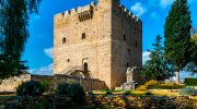
Medieval Kolossi Castle, once the base of Knights of St. John, sits near the route’s start. The Cyprus Wine Museum in Erimi village provides comprehensive information about 5,000 years of Cypriot winemaking history before visitors head into the mountain villages.
Marathasa Valley Northern Approach
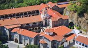
The Marathasa Valley offers an alternative northern route through Troodos. This path passes through Pedoulas, a small village staggered down the mountainside with views of the Mediterranean in the distance. Pine woods and cherry trees grow between houses with bright orange rooftops. The village features Archangelos Mihail Church, a UNESCO World Heritage Site, and serves as the starting point for trails leading to the impressive Kykkos Monastery.
Kalopanagiotis sits lower in the valley along the Clarios River. The village features four churches, most notably Agios Nikolaos tis Stegis, another UNESCO site. The old village retains traditional architecture and serves as a base for hiking and mountain biking on nearby trails including the Atalanti and Kampos Tou Livadiou nature paths.
Practical Mountain Driving Considerations
Mountain roads in Cyprus vary dramatically in quality. Main routes like the B8 feature excellent pavement and clear signage. Secondary roads through smaller villages can be narrow with limited passing opportunities. Fuel stations become scarce in mountain areas, making it essential to fill up before leaving coastal cities.
Speed limits drop to 50 or 65 kilometers per hour through villages. Police enforce these limits actively, particularly on popular routes. Summer driving requires functional air conditioning, as temperatures inside vehicles can become uncomfortable even at higher elevations during midday hours.

Winter brings specific challenges. Snow closes higher elevation roads regularly between January and March, sometimes for extended periods. Checking road conditions before departure is essential. The Cyprus Ski website provides real-time information about snow conditions and road status for travelers planning winter mountain trips.
Parking in popular villages like Omodos fills rapidly during weekends and summer months. Early morning arrivals secure spaces and avoid crowds. Most villages offer free parking, though finding available spots during peak periods requires patience and flexibility.
The Role of Mountain Roads in Preserving Cypriot Heritage
The Troodos Mountains offer escape from coastal heat and crowds while preserving traditional Cypriot village life. These routes connect visitors to Cyprus’s agricultural heritage, Byzantine religious art, and winemaking traditions spanning millennia. The temperature difference alone, sometimes 15 degrees cooler than coastal areas, makes mountain drives worthwhile during summer.
Environmental diversity increases with elevation. Coastal areas feature Mediterranean scrubland, while mountain zones support pine and cedar forests with endemic species. This ecological variation creates scenic interest throughout the climbing routes.
Mountain villages face population decline as young people move to cities, making tourism economically important for maintaining these communities. Well-preserved traditional architecture, local tavernas, and family wineries depend on visitor interest to remain viable. The improved road network and agrotourism initiatives help sustain village economies while sharing authentic Cypriot culture with travelers seeking experiences beyond beach resorts.