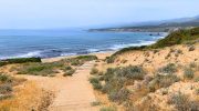
Most visitors meet Cyprus at sea level, through beaches and coastal towns. But the island’s character is shaped just as much by what rises behind it. From volcanic peaks and forested ridges to monastery balconies and fire lookout stations, Cyprus’s high ground offers a different kind of understanding. These elevated viewpoints are not simply scenic stops. They explain how the island was formed, how people survived, and how geography quietly directed history, belief, and daily life.
This is Cyprus seen vertically, where altitude changes perspective.
- An island lifted from the sea
- The calm authority of the Troodos peaks
- Where rock walls meet the sky: the Madari ridge
- Valleys shaped by people, not just altitude
- The wild west: Paphos Forest and the Cedar Heights
- Where city and mountain meet
- Monasteries built to see and to endure.
- A different skyline in the north
- Why Cyprus’s viewpoints matter
An island lifted from the sea
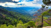
Cyprus’s mountainous backbone exists because the island itself was pushed upward from the ancient Tethys Ocean. The Troodos Mountains are one of the world’s most complete examples of exposed oceanic crust, known as an ophiolite. What was once seabed now reaches nearly 2,000 metres above sea level, creating an interior landscape that feels unexpectedly vast for an island.

This geological lift matters visually. Dark volcanic rock, steep valleys, and broad domed summits give the highlands a sense of scale that contrasts sharply with the coast. From many viewpoints, you can see both shores of Cyprus on a clear day, a reminder of how compact yet varied the island really is.
The calm authority of the Troodos peaks
At the centre of this vertical world stands Mount Olympus (Chionistra), the island’s highest point. While the summit itself is restricted, the surrounding trails provide Cyprus’s most expansive high-altitude views.

The Artemis and Atalante nature trails circle the mountain just below the peak, passing through ancient black pine and juniper forests. From certain stretches, the land seems to fall away in every direction. North toward Morphou Bay. South toward Limassol and the Akrotiri Peninsula. The experience is not dramatic in a cinematic sense. It is steady, spacious, and quietly commanding.
These trails reveal something important. Cyprus’s interior was never empty or forgotten. It was lived in, walked through, worked, and watched from above.
Where rock walls meet the sky: the Madari ridge
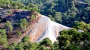
East of the central massif, the landscape sharpens. The Adelfoi Forest and the Madari ridge introduce a more rugged character, where erosion has carved volcanic rock into vertical formations known locally as the “Walls of Madari.”
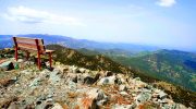
The Madari Fire Lookout Station sits at over 1,600 metres, offering one of the most complete panoramas on the island. From this single point, you can trace mountain villages, terraced slopes, forests, and coastline without moving your feet. It is a viewpoint that makes Cyprus feel legible, almost mapped.
These lookout points were never purely aesthetic. They existed for surveillance, fire detection, and orientation. Beauty came as a byproduct of usefulness.
Valleys shaped by people, not just altitude
As elevation gradually eases away from the highest peaks, the northern slopes of Troodos open into the Marathasa and Solea valleys, where the island’s relationship with height becomes more personal. Here, viewpoints do not dominate the landscape. They frame it.
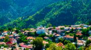
In villages such as Pedoulas, orchards spill down hillsides below tiled roofs and church towers, creating views that feel layered rather than distant. In Kalopanayiotis, footpaths rise gently to ridges overlooking monasteries, stone bridges, and river-fed valleys that have supported settlement for centuries. These viewpoints do more than display scenery. They reveal a landscape shaped by terraces, water channels, and deliberate adaptation to steep ground.
Unlike the exposed authority of the peaks, valley viewpoints feel lived-in. They show how Cypriots learned to inhabit height not by overcoming it, but by adjusting their lives around it.
The wild west: Paphos Forest and the Cedar Heights
Further west, the mountains relax their grip, spreading into the broad, wooded highlands of Paphos Forest. Here, elevation feels less engineered and more instinctive, with viewpoints emerging from clearings rather than platforms.
At Tripylos Peak, the highest point in the forest, the sensation is one of continuity rather than spectacle. Cedar trees stretch outward in every direction, interrupted only by distant glimpses of the Akamas Peninsula and the faint outline of Morphou Bay. The absence of towns, roads, and visible infrastructure is striking. Silence becomes part of the view.
These western highlands remind visitors that not all of Cyprus’s elevated ground was settled or reshaped. Some areas remained intentionally difficult to access, preserved as ecological strongholds and natural boundaries long before conservation became a concept.
Where city and mountain meet
Closer to Limassol, elevation begins to interact directly with urban life. Trails around Kyparissia Peak and nearby ridges overlook reservoirs, forests, and expanding suburbs, creating views that quietly explain the city’s dependence on the mountains behind it.
From these transitional viewpoints, Cyprus’s water story becomes visible. Dams sit deep within valleys. Forested slopes protect catchment areas. Pipelines and access roads trace careful paths through difficult terrain. Height here is not symbolic. It is functional, supporting coastal life without ever fully separating from it.
These are not wild viewpoints, nor are they remote. They occupy the space between nature and settlement, revealing how closely the two remain linked.
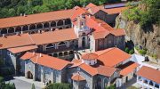
Monasteries built to see and to endure.
Some of Cyprus’s most enduring viewpoints were chosen with spiritual intention as much as strategic awareness. Kykkos Monastery, set high on the western slopes of Troodos, overlooks forests and valleys with a sense of deliberate distance from the world below.
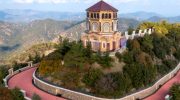
Nearby, the Throni shrine offers broad northern views that reinforce why such locations were selected. Elevation provided protection, solitude, and clarity, allowing monastic life to endure through political shifts and external pressure. Long before viewpoints were valued for beauty, they were valued for survival.
These religious sites reflect a recurring Cypriot understanding of height. To rise above the land was to gain safety, perspective, and permanence.
A different skyline in the north
Along the northern coast, the Kyrenia Range presents a sharper, more abrupt form of elevation. Composed primarily of limestone, its narrow ridges rise suddenly from the sea, creating a skyline that feels defensive rather than expansive.

From castles such as St. Hilarion, the drop toward the coast is immediate. The view is commanding, but its purpose was never contemplative. These heights were built to watch ships, control movement, and respond quickly to threats. Geography here served strategy first, story later.
Over time, myth and legend softened the range into tales of giants and heroic hands, yet the original function of these viewpoints remains visible in their placement and form.
Why Cyprus’s viewpoints matter
Cyprus’s high-altitude viewpoints are not pauses between destinations. They are explanations. Each one reveals how geology created opportunity, how communities responded to limitation, and how elevation became a tool rather than an obstacle.
From volcanic summits and orchard ridges to fire lookout stations and monastery balconies, these elevated places show an island shaped as much by ascent as by shoreline. To understand Cyprus fully, one must look down from its heights and see how land, water, belief, and survival align.
Seen from above, the island finally makes sense.