The Ezousa Natural Trail offers a unique window into the diverse landscapes of Cyprus. This path winds through the verdant Ezousa Valley, which remains one of the most important ecological sites on the island. Visitors find themselves surrounded by rugged cliffs and gentle water flows that define the local geography.
The journey begins near the village of Kannaviou where the air feels cool and fresh. Travelers witness a transition from agricultural plots to wild riverine thickets. This area serves as a sanctuary for numerous bird species and endemic plants. The trail provides an immersive experience for those who seek peace and natural beauty.
Conservation efforts ensure that the trail maintains its pristine condition for future generations. It acts as a bridge between the historical land use of the Paphos district and modern environmental protection. Every step reveals a new detail about the geological past of this Mediterranean gem.
- Trail Overview
- Geological Significance and Landscape Evolution
- Floral Diversity and Riparian Vegetation
- Avian Habitats and Local Wildlife
- Historical Context and Cultural Heritage
- Hydrology and the Ezousa River System
- Practical Considerations for Hikers
- Seasonal Transformations and Visual Appeal
- Conservation and Environmental Protection
Trail Overview
- Location: Ezousa Valley, Paphos District, Cyprus
- Distance: 5 miles (8 km)
- Route Type: Loop
- Difficulty: Moderate
- Elevation Gain: 525 feet (160 meters)
- Duration: 3 hours
- Best Time to Visit: February – May
- Terrain: Dirt paths and river stones
Geological Significance and Landscape Evolution
The Ezousa Valley stands as a testament to the complex tectonic history of Cyprus. The trail sits atop the Mamonia Complex which consists of diverse rock types that date back millions of years. As visitors walk, they observe dramatic limestone outcrops that contrast with the darker volcanic rocks. The river itself has carved deep into the earth over centuries to create a fertile floor.
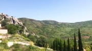
This process creates a microclimate that stays significantly cooler than the coastal plains. The soil depth varies across the route and supports different types of vegetation based on mineral content. Large boulders often line the path and show signs of ancient water erosion. These stone formations tell a story of a time when water levels were much higher. The structural integrity of the valley walls provides stability for the trail.
Floral Diversity and Riparian Vegetation
Plant life along the Ezousa Natural Trail thrives due to the constant presence of water. The riverbanks host dense stands of oriental plane trees and alder trees. These species provide a thick canopy that shields hikers from the intense sun. Rare orchids bloom in the shaded areas during the early spring months. Traditional Mediterranean scrub known as maquis covers the higher slopes.
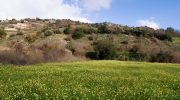
Here, lentisk and terebinth bushes dominate the landscape with their deep green hues. Wild herbs like thyme and sage scent the air and offer a glimpse into the local flora. The transition from the wet river zone to the dry hillside happens abruptly. This creates distinct zones of life that fascinate botanists and casual observers alike. No two sections of the trail look the same because the plant composition shifts with the sun exposure.
Avian Habitats and Local Wildlife
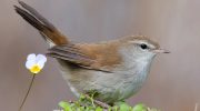
The valley serves as a crucial corridor for migratory birds that travel between Europe and Africa. Birdwatchers often spot the Cyprus Wheatear which is a bird found nowhere else in the world. The steep cliffs provide ideal nesting sites for the Bonelli’s Eagle and the Long-legged Buzzard. In the quieter sections, the sound of the Cetti’s Warbler echoes through the reeds.
Reptiles also find a home among the sun-drenched rocks of the trail. The Cyprus Whip Snake moves quickly through the underbrush but poses no threat to humans. Amphibians gather near the water pools where the flow slows down. These creatures rely on the clean water of the Ezousa River to survive. The ecological balance of the valley depends on the health of these various species. Each animal plays a role in the pollination and pest control of the region.
Historical Context and Cultural Heritage
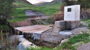
Human history intertwines with the natural landscape of the Ezousa Valley. Ancient watermills sit in ruins along the river and remind visitors of old grain production methods. These structures utilized the power of the river to serve nearby mountain villages. Stone bridges still span some sections of the water and showcase traditional craftsmanship. The trail passes near abandoned settlements that people once inhabited for safety and resources.
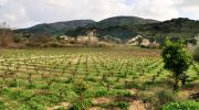
Modern agriculture still exists on the outskirts where olive groves and vineyards stretch across the hills. Local folklore often mentions the valley as a place of refuge and mystery. The connection between the land and the people remains strong through these physical markers of the past. Hikers gain an appreciation for the toil of previous generations who worked this rugged terrain.
Hydrology and the Ezousa River System
The Ezousa River is one of the few watercourses in Cyprus that maintains some flow throughout the year. Its headwaters start high in the Troodos Mountains and descend toward the sea. The trail follows the middle section where the water creates deep pools and small rapids. This water system recharges the local aquifer which provides essential resources for the Paphos region.
During the winter rains, the river can transform into a powerful force that reshapes the banks. In the summer, the flow reduces to a trickle but still supports the surrounding life. The sound of moving water serves as a constant companion for those on the trail. Conservationists monitor the water quality to protect the delicate aquatic ecosystem. The river is the lifeblood of the valley and dictates the rhythm of the seasons.
Practical Considerations for Hikers
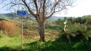
Preparation ensures a safe and enjoyable trek through the Ezousa Valley. The path consists of uneven ground so sturdy footwear is a requirement. Water remains scarce once a person leaves the village start point. One must carry a sufficient supply of fluids to stay hydrated. Sun protection is vital even in the cooler months because the UV rays remain strong.
Mobile signal can be intermittent in the deeper parts of the gorge. It is wise to inform someone of the intended return time before the start. The trail markings are generally clear but focus is necessary at river crossings. Flash floods can occur after heavy rain in the mountains so weather checks are essential. Respect for the environment means that all trash must leave with the visitor.
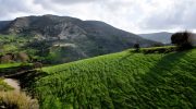
Seasonal Transformations and Visual Appeal
The appearance of the trail changes dramatically as the months pass. Autumn brings a subtle shift in color as the deciduous trees shed their leaves. Winter rains turn the entire valley into a lush green paradise with rushing water. Spring offers the most spectacular display of wildflowers and active wildlife. The heat of summer provides a different challenge but the shade of the trees offers some relief.
Each season provides a new perspective on the resilience of the Cyprus landscape. Photographers find endless subjects in the play of light against the canyon walls. The morning light specifically highlights the textures of the rock and the dew on the leaves. Sunset casts long shadows that give the valley a dramatic and quiet atmosphere.
Conservation and Environmental Protection
The Ezousa Valley falls under the Natura 2000 network which protects European biodiversity. This designation limits development and ensures that the habitat remains intact. Human impact on the trail is carefully managed to prevent erosion and disturbance to nests. Educational signs along the route explain the importance of the various species. Local authorities work to remove invasive plants that threaten the native balance.
The success of these efforts shows in the return of rare species to the area. Visitors contribute to conservation by staying on the marked paths and avoiding the removal of plants. This collective responsibility keeps the Ezousa Natural Trail a premier destination for eco-tourism. The beauty of the site relies on the continued respect of those who walk its length.


