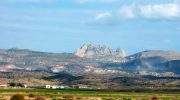
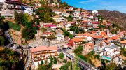
Kalopanayiotis is a mountain village located in the Nicosia District, approximately 70 kilometers from both Nicosia and Limassol. The settlement lies on the eastern bank of the Setrachos River in the Marathasa Valley at an altitude of around 700 meters within the Troodos Mountains region.
The village is one of the first settlements encountered when entering the Marathasa Valley from the direction of Nicosia. Its name is generally linked to “kalo” (meaning good or beautiful in Greek) combined with a personal or religious name, although its exact linguistic origin remains subject to interpretation.
Historical Background
Archaeological and historical references suggest that the Kalopanayiotis area was known in antiquity for its natural mineral springs, particularly sulfur-rich waters emerging along the Setrachos River. These natural resources contributed to early settlement activity and seasonal use of the area.
During antiquity, the region formed part of the territory associated with the ancient kingdom of Soli. Historical sources indicate that natural springs in mountainous areas of Cyprus were often used for therapeutic bathing practices, a tradition that continued into the Roman and Byzantine periods.

The site is also linked to the remains of an ancient healing center, commonly referred to in historical studies as an Asclepieion, a type of sanctuary where water-based treatments were combined with ritual practices in the Greco-Roman world. Such centers were typically associated with wellness, rest, and recuperation rather than purely residential settlement.
Over time, use of the springs continued in different forms through Byzantine, Frankish, and Ottoman periods, adapting to changing social and administrative conditions. In the 20th century, local accounts describe renewed use of the waters for bathing and wellness-related practices, particularly between the early and mid-1900s.
Monastery of Agios Ioannis Lampadistis Complex
A major historical landmark in the village is the monastic complex of Agios Ioannis Lampadistis Monastery. This complex is widely recognized for its architectural layering and preservation of Cypriot wall painting traditions spanning several centuries.
The oldest part of the complex dates to the 11th century and includes multiple church structures built at different times and later joined under a single roof. The site reflects a long architectural evolution, with additions and reconstructions carried out between the Byzantine, Lusignan, and Ottoman periods.
The southern church, associated with Agios Herakleidios, contains fragmentary frescoes dating from the 11th and 12th centuries, with additional decorative layers added in later centuries. These wall paintings illustrate the development of religious art in Cyprus across multiple historical phases.
The central structure, associated with Agios Ioannis Lampadistis, was originally constructed above a burial site tradition linked to the local monastic community. The present form largely reflects reconstruction work carried out in the 18th century after earlier structural changes and collapses.
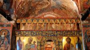
The northern chapel, often referred to in historical descriptions as the Latin Chapel, was added during the Lusignan period in the 15th century. It reflects the coexistence of different architectural and cultural influences in Cyprus during periods of Western European rule.
Architecture and Village Structure
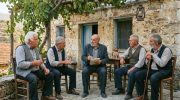
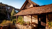
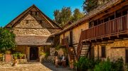
Kalopanayiotis is characterized by traditional mountain village architecture adapted to steep terrain. Houses are built using local stone and arranged in terraced formations along the hillside. Many structures include wooden balconies, tiled roofs, and enclosed courtyards designed for seasonal climate conditions.

The village layout follows natural contours of the valley, with narrow streets and stepped pathways connecting residential areas. Several buildings have been designated as preserved structures under heritage protection frameworks, ensuring the continuation of traditional architectural styles.
From the late 20th century onward, restoration initiatives supported by public and regional development programs led to the rehabilitation of abandoned houses. Many of these structures were converted into guest accommodations while retaining their original external architectural character.
Natural Springs and Wellness Heritage
Kalopanayiotis is historically associated with sulfur-rich mineral springs located along the Setrachos River. These natural waters emerge near the riverbed and have been used locally for bathing and wellness practices for generations.

Historical accounts describe the area as a seasonal destination for visitors seeking rest in natural surroundings. The springs became part of local wellness traditions that evolved over time, shifting between informal bathing areas and later organized facilities.
Modern spa facilities in the village incorporate these natural water sources into contemporary wellness services. These developments represent a continuation of long-standing local use of mineral-rich waters, adapted to current tourism and health practices.
Cultural and Tourism Development
In recent decades, Kalopanayiotis has undergone structured restoration and tourism development aimed at preserving its architectural identity while supporting local economic activity. Many restored houses now serve as accommodation, dining, or cultural spaces.
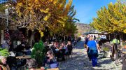
The village is part of broader heritage and mountain tourism routes in the Troodos region, attracting visitors interested in traditional architecture, natural landscapes, and historical sites. Walking paths and river routes connect different parts of the settlement and surrounding valley.
Visiting Kalopanayiotis
Kalopanayiotis is accessible by road from both Nicosia and Limassol, with travel times of approximately 90 minutes depending on route and traffic conditions. The journey passes through mountainous terrain and forested areas of the Troodos range.
The village includes a managed traffic system with designated parking areas at key access points. Narrow streets limit vehicle movement within central areas, encouraging pedestrian exploration.
The monastic complex of Agios Ioannis Lampadistis operates as a preserved cultural site with set visiting hours that may vary seasonally. Entry policies and photography restrictions apply in certain interior areas to protect wall paintings and historical surfaces.
Nearby natural features, including riverbanks and forest walking routes, remain accessible for visitors interested in exploring the landscape surrounding the village.
Historical and Cultural Significance
Kalopanayiotis represents a layered historical settlement where natural geography, water resources, and architectural development have shaped continuous human activity over centuries. Its combination of ancient springs, medieval religious architecture, and traditional village structures reflects broader patterns of mountain life in Cyprus.
Today, the village is recognized as a cultural heritage destination within the Troodos region. It demonstrates how historical settlements can adapt to modern tourism while maintaining architectural continuity and environmental character.