Cyprus offers diverse terrain for walkers and cyclists, from coastal paths to mountain trails. The island covers 9,251 square kilometers and features everything from sea-level beaches to Mount Olympus at 1,952 meters.
With approximately 90 walking trails and 45 designated cycling routes, Cyprus attracts outdoor enthusiasts year-round. The compact size means you can experience dramatic changes in scenery within short distances.
Most trails are managed by the Department of Forests, while villages maintain additional local routes. The infrastructure includes marked paths, information boards, and benches at viewpoints, making exploration accessible to various fitness levels.
The Historical Development of Active Routes
Cyprus developed its trail network gradually over decades. The E4 European Long Distance Path section opened in 2005, connecting Larnaca and Paphos airports across 540 to 660 kilometers. This addition made Cyprus part of a 10,450-kilometer route stretching from Gibraltar to Cyprus through nine countries. Nature trails in areas like Troodos and Akamas existed before the E4, but the long-distance path created a unified system.
The European Ramblers Association coordinates the E4 internationally, while the Cyprus Tourism Organisation manages the national cycling network. Many trails follow ancient routes, including old camel trails once used to transport copper from mines to ports. Medieval Venetian bridges from the 15th century mark some historic pathways. The network expansion continues, with new routes added regularly to accommodate different skill levels.
Main Walking Trail Networks and Characteristics
The Troodos Mountains contain the highest concentration of walking trails. The Artemis Trail circles Mount Olympus at 1,850 meters elevation over seven kilometers, taking two to three hours to complete. This trail passes through black pine forests and includes 500-year-old trees. The Atalante Trail connects Troodos Square to various points through dense woodland. The Caledonia Trail, covering three kilometers, leads to Cyprus’s tallest waterfall and ranks as one of the most popular walks. Trail difficulty ranges from grade one (easy) to grade three (challenging terrain).
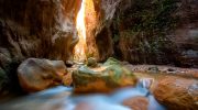
The Akamas Peninsula in western Cyprus offers coastal and inland routes. The Aphrodite Trail provides views of the Mediterranean, Blue Lagoon, Cape Arnaoutis, and Paphos Forest. The Adonis Trail follows the north coast with 350 meters of ascent over seven kilometers. Avakas Gorge presents a challenging three-kilometer route through a limestone canyon carved by a river over thousands of years. The gorge can be impassable during rainy seasons due to high water levels.
The E4 path crosses varied landscapes from coast to mountains. Popular sections include Pegeia to the Baths of Aphrodite, passing Lara Bay and through the Akamas Peninsula. The Stavros tis Psokas to Lysos section covers 28 kilometers along the river where wild mouflon inhabit pine forests. The trail reaches nearly 2,000 meters in the Troodos interior, requiring preparation for different weather conditions between mountains and coast. Completing the entire Cyprus E4 takes at least two weeks at 45 to 50 kilometers daily.
Cycling Routes and Infrastructure
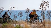
Cyprus maintains 45 designated cycling routes across varied terrain. The island’s compactness allows rapid changes from rocky to clay surfaces and steep to flat gradients within 10 kilometers. This variety creates natural challenges for both road cyclists and mountain bikers. Coastal towns like Paphos, Limassol, Larnaca, and Nicosia serve as starting points for routes heading inland toward mountains or along the coast.

The Troodos Mountains offer extensive gravel trails through forested river valleys on the western slopes. Hundreds of kilometers of wide gravel paths suit mountain bikes, with well-maintained trails throughout Troodos and Paphos forests. Mount Olympus climbs attract experienced cyclists despite steep grades. Forest roads feature single-digit gradients initially, then increase to 7 to 12 percent on higher sections.
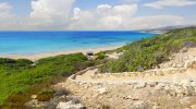
Coastal routes include the 15-kilometer flat path from Latchi harbor to the Baths of Aphrodite along the Akamas Peninsula. Cyclists can continue west on the Akamas Trail for another 15 kilometers to Cape Arnauti, facing sharp descents along creeks and sand bars. The Akamas Ridge route from Latchi involves a 600-meter climb over 30 kilometers but rewards riders with views over the Baths of Aphrodite and Lara Beach.
Cyprus hosts the Gran Fondo Cyprus, a UCI Gran Fondo World Championships qualifier, demonstrating the island’s commitment to cycling. The Cyprus Cycling Federation has organized road races since 1978. However, infrastructure favors mountain biking over road cycling. Dedicated cycle lanes in towns often lack proper on and off ramps for road bikes. Coastal roads require riding with traffic, and cyclists typically use shoulders with gravel.
Specific Trail Details and Difficulties
The Madari Circular Trail covers 14 kilometers through the Madari mountain range at approximately 1,700 meters altitude. This moderately challenging route starts in Spilia village and leads to the Madari Fire Lookout Station with panoramic views. The trail features steep ascents and descents with dramatic rock formations, golden oak, cedar, wild roses, and strawberries.
The Kannoures Trail to Kakopetria crosses the Solea valley, starting at Karkotis River and ending in Kakopetria village. This difficult downhill trail passes Agios Nikolaos tis Stegis church, a UNESCO World Heritage site with 12th-century frescoes. The route allows dogs on leashes.
The Germasogeia Dam Trail (Phoinikaria) in Limassol District provides moderate difficulty with water views. The Marathasa Trail offers various lengths from 10 to 20 kilometers. The Prodromos Dam to Stavroulia Trail begins at 1,499 meters and features black pine rows with views of Marathasa valley, Morfou Bay, Kykkos Monastery, and Mount Troodos. The three-kilometer route takes one to one and a half hours.
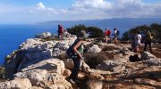
Cape Greco National Park on the east coast offers accessible trails for families and beginners. The area features sea caves, coastal formations, and relatively flat terrain. Mountain bikers find technical challenges on steeper Troodos sections with narrow, winding paths requiring advanced skills.
Best Times and Practical Considerations
Spring (March to June) and autumn (October to December) provide optimal conditions for active travel. Temperatures remain moderate, avoiding summer heat that can exceed 40 degrees Celsius. Mountain areas stay cooler, offering refuge during July and August. Winter brings rain to coastal areas and snow to Troodos, creating different challenges. Cyprus receives approximately 300 days of sunshine annually, ensuring reliable weather most of the year.

Summer walking requires early morning or late evening timing to avoid peak heat. Sunscreen, hats, adequate water, and light clothing are essential. Troodos trails remain viable during summer due to altitude cooling. Winter demands warm layers, waterproof jackets, and sturdy closed-toe shoes, especially for mountain areas. The mild coastal temperatures still allow outdoor activities with extra layers for evenings.
Trail marking quality varies. Main routes like the E4 and popular nature trails display clear signage with information boards at starting points. Remote forest areas may have inconsistent marking, requiring GPS navigation or detailed maps. Plants and trees are labeled along many trails for educational purposes. Benches appear at viewpoints for rest stops.

Water sources in remote areas require advance research. Fountains exist on some trails, but not all. Carrying sufficient supplies is critical, particularly on long Troodos or E4 sections crossing uninhabited forest. Food availability also varies, with villages offering supplies at route start and end points but nothing in between.
How Active Travel Enriches the Cyprus Experience
Cyprus transforms from a beach destination to an outdoor adventure paradise through its trail networks. The combination of historical routes, natural diversity, and modern infrastructure creates opportunities for multi-day expeditions or single-day excursions. Walkers experience UNESCO heritage sites, endemic flora, and dramatic landscapes while following ancient paths. Cyclists challenge themselves on mountain ascents or enjoy leisurely coastal rides with Mediterranean views. The year-round accessibility, safety standards, and range of difficulty levels make Cyprus suitable for families, experienced athletes, and everyone between. These routes preserve Cyprus’s natural heritage while allowing visitors to explore beyond tourist centers and connect with the island’s authentic character.


